- East Northamptonshire
-
For the former parliamentary constituency, see East Northamptonshire (UK Parliament constituency).
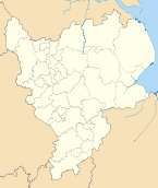
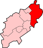
East Northamptonshire District — Non-metropolitan district — East Northamptonshire shown within Northamptonshire Sovereign state United Kingdom Constituent country England Region East Midlands Non-metropolitan county Northamptonshire Status Non-metropolitan district Admin HQ Thrapston Incorporated 1 April 1974 Government – Type Non-metropolitan district council – Body East Northamptonshire Council – Leadership Alternative - Sec.31 (Conservative) – MPs Peter Bone
Louise MenschArea – Total 196.8 sq mi (509.8 km2) Area rank 90th (of 326) Population (2010 est.) – Total 85,300 – Rank 270th (of 326) – Density 433.4/sq mi (167.3/km2) – Ethnicity 98.3% White Time zone GMT (UTC0) – Summer (DST) BST (UTC+1) ONS code 34UD OS grid reference TL0192784659 Website www.east-northamptonshire.gov.uk East Northamptonshire (officially "The District of East Northamptonshire") is a local government district in Northamptonshire, England. Its council is based in Thrapston and Rushden, which is the largest town in the area. Other towns include Oundle, Raunds, Irthlingborough and Higham Ferrers.
The district borders onto the Borough of Corby, the Borough of Kettering, the Borough of Wellingborough, the Borough of Bedford, the Soke of Peterborough, the county of Cambrideshire and the county of Rutland.
The district was formed on 1 April 1974, under the Local Government Act 1972, by a merger of the municipal borough of Higham Ferrers, with the urban districts of Irthlingborough, Oundle, Raunds and Rushden, along with Oundle and Thrapston Rural District, and Newton Bromswold from Wellingborough Rural District.
The district is home to the beautiful wooded areas of Fineshade Wood, Wakerley Great Wood and Fermyn Wood in the remaining existing parts of Rockingham Forest, at one time a royal hunting forest.
The district is also home to several of Northamptonshire's airfields including Spanhoe airfield, King's Cliffe airfield, Deenethorpe airfield, Polebrook airfield, Chelveston airfield and Lyveden airfield.
The vast majority of East Northamptonshire is included in the Corby parliamentary constituency and is currently served by Louise Mensch MP. The only settlements in East Northants which are excluded from the Corby parliamentary constituency are Higham Ferrers and Rushden, which instead are included in the "Wellingborough and Rushden" parliamentary constituency currently served by Peter Bone MP.
Election results 2007 (total 40 seats)
Conservative - 39 seats (+ 6) Labour - 0 seats ( - 3) Independent - 1 seat
Election results 2003 (total 36 seats)
Conservative - 33 seats (+ 12) Labour - 3 seats (- 12)
Geography
There are six towns in the district. Rushden is by far the largest with a population of 25,849. It is situated in the very south of the district. The second largest town is Raunds with a population of around 8,000. The smallest town in the district is Thrapston where the HQ of the East Northamptonshire council is located. Oundle is a historical market town with many ancient buildings and a large Public School. Higham Ferrers, which is part of Rushden's urban area, was the birthplace for Henry Chichele and chichele college. Irthlingborough is home to Rushden & Diamonds Football Club.
There are no railway stations in East Northamptonshire. There is one College in East Northamptonshire.
Settlements and parishes
- Achurch, Aldwincle, Apethorpe, Ashton
- Barnwell, Benefield, Blatherwycke, Brigstock, Bulwick
- Chelveston cum Caldecott, Clopton, Collyweston, Cotterstock
- Deene, Deenethorpe, Denford, Duddington-with-Fineshade
- Easton-on-the-Hill
- Fotheringhay
- Glapthorn, Great Addington
- Hargrave, Harringworth, Hemington, Higham Ferrers
- Irthlingborough, Islip
- King`s Cliffe
- Laxton, Lilford-cum-Wigsthorpe
- Little Addington, Lowick, Luddington, Lutton
- Nassington, Newton Bromswold
- Oundle
- Pilton, Polebrook
- Raunds, Ringstead, Rushden
- Shotley, Southwick, Stanwick, Stoke Doyle, Sudborough
- Tansor, Thrapston, Thurning, Thorpe Waterville, Titchmarsh, Twywell
- Wadenhoe, Wakerley, Warmington, Woodford, Woodnewton
- Yarwell
Ceremonial county of Northamptonshire Boroughs or districts - Corby
- Daventry
- East Northamptonshire
- Kettering
- Northampton
- South Northamptonshire
- Wellingborough
Major settlements Rivers Canals Topics Derbyshire Amber Valley • Bolsover • Chesterfield • Derby • Derbyshire Dales • Erewash • High Peak • North East Derbyshire • South Derbyshire

Leicestershire Lincolnshire Nottinghamshire Ashfield • Bassetlaw • Broxtowe • Gedling • Mansfield • Newark and Sherwood • Nottingham • Rushcliffe
Northamptonshire Corby • Daventry • East Northamptonshire • Kettering • Northampton • South Northamptonshire • Wellingborough
Rutland
Wikimedia Foundation. 2010.

