- North East Derbyshire
-
North East Derbyshire District — District — Shown within Derbyshire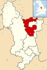
Sovereign state United Kingdom Constituent country England Region East Midlands Ceremonial county Derbyshire Founded Admin. HQ Chesterfield Government - Type North East Derbyshire District Council - Leadership: Leader & Cabinet - Executive: Labour - MPs: Natascha Engel, Dennis Skinner Area - Total 106.4 sq mi (275.6 km2) Area rank 148th Population (2010 est.) - Total 98,300 - Rank Ranked 229th - Density 923.8/sq mi (356.7/km2) Time zone Greenwich Mean Time (UTC+0) - Summer (DST) British Summer Time (UTC+1) Postcode ISO 3166-2 ONS code 17UJ OS grid reference NUTS 3 Ethnicity 98.9% White Website ne-derbyshire.gov.uk North East Derbyshire is a local government district in Derbyshire, England. It borders the districts of Chesterfield, Bolsover, Amber Valley and Derbyshire Dales in Derbyshire, and Sheffield and Rotherham in South Yorkshire.
The district offices are based outside the district, in the town of Chesterfield, which the district surrounds on three sides, and thus acts as the shopping and work centre for much of the district.
Settlements in the district include:
- Arkwright Town,
- Ashover
- Barlow
- Calow
- Clay Cross
- Dronfield
- Eckington
- Grassmoor
- Holmesfield
- Holymoorside
- Holmewood
- Killamarsh
- North Wingfield
- Pilsley
- Renishaw
- Ridgeway
- Shirland
- Spinkhill
- Stonebroom
- Tupton
- Wingerworth
The district was formed on April 1, 1974, under the Local Government Act 1972. It was a merger of the Clay Cross and Dronfield urban districts along with all but one parish of Chesterfield Rural District.
Coal mining
The district, along with the district of Bolsover and much of the surrounding area of South Yorkshire, was a major producer of coal when a large seam was discovered during the building of the Clay Cross railway tunnel. Coal mining became the main industry of the region. During the 1980s the Conservative government closed down many of the mines after a dispute between the government and the National Union of Mineworkers, which is known as the miners' strike.
The strike began when the government reneged on previous declarations and announced the closure of the majority of pits due to unprofitability and inefficiency. The strike lasted for a year between 1984 and 1985. The strike was observed by approximately 70% of miners in North East Derbyshire. It caused massive social upheaval as traditionally close-knit communities became divided between those who worked and those who didn't. Striking miners went unpaid and were not entitled to state welfare benefits, meaning that thousands of families relied on handouts and poverty became rife.
The strike was resolved by the spring of 1985, when the government effectively defeated the NUM and continued its policy of mine closures. The closure of the pits resulted in the closure of many associated industries, which decimated the local communities. Many former pit villages have struggled to recover. There are now no deep pit mines left in North East Derbyshire.
Regeneration
Following the closure of the pits there were large areas of the district left derelict, with old mine workings and spoil tips from the last 150 years of industrialisation. Over the last few years these sites have been re mediated and regenerated by open cast mining the remaining surface deposits and reclamation of coal from the old spoil heaps. The sites have then being restored as a mix of parkland, business parks and housing sites. A lot of the work being part funded by EEC Coalfield community regeneration grants, to provide money to help clean up the environmental legacy and fund the creation of job opportunities by providing the infrastructure for developments. This has resulted in several large and some smaller business parks, now providing jobs for thousands of people. But not of the same skill level of the old engineering jobs lost. A lot being warehousing and distribution, as opposed to the old engineering trades.
Ceremonial county of Derbyshire Unitary authorities Boroughs or districts Amber Valley • Bolsover • Chesterfield • Derbyshire Dales • Erewash • High Peak • North East Derbyshire • South DerbyshireMajor settlements Alfreton • Ashbourne • Bakewell • Belper • Bolsover • Buxton • Chapel-en-le-Frith • Chesterfield • Clay Cross • Darley Dale • Derby • Dronfield • Eckington • Glossop • Hadfield • Heanor • Ilkeston • Killamarsh • Langley Mill • Long Eaton • Matlock • Melbourne • New Mills • Ripley • Sandiacre • Shirebrook • Staveley • Swadlincote • Whaley Bridge • Wirksworth
See also: List of civil parishes in DerbyshireRivers Topics Derbyshire Amber Valley • Bolsover • Chesterfield • Derby • Derbyshire Dales • Erewash • High Peak • North East Derbyshire • South Derbyshire
Leicestershire Lincolnshire Nottinghamshire Ashfield • Bassetlaw • Broxtowe • Gedling • Mansfield • Newark and Sherwood • Nottingham • Rushcliffe
Northamptonshire Rutland Categories:- Local government in Derbyshire
- Non-metropolitan districts of Derbyshire
- Local government districts of the East Midlands


Wikimedia Foundation. 2010.