- Crowle, Lincolnshire
-
Coordinates: 53°36′26″N 0°49′56″W / 53.607350°N 0.832108°W
Crowle 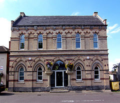
Market Hall in Crowle
 Crowle
Crowle shown within LincolnshirePopulation 4,090 (2001 census) OS grid reference SE7712 Parish Crowle Unitary authority North Lincolnshire Ceremonial county Lincolnshire Region Yorkshire and the Humber Country England Sovereign state United Kingdom Post town Scunthorpe Postcode district DN17 Police Humberside Fire Humberside Ambulance East Midlands EU Parliament Yorkshire and the Humber List of places: UK • England • Lincolnshire Crowle (rhymes with coal) is a small town and civil parish on the Isle of Axholme in North Lincolnshire, England. It lies on the Stainforth and Keadby Canal and has a railway station. Notable buildings in the town include the parish church, in which can be seen the Crowle Stone runic cross shaft, and the Gothic revival market hall.
History
Crowle was one of the last largest pieces of dry land on the north of the Isle of Axholme when the area emerged from Lake Humber after the last Ice Age. The present settlement developed between Mill Hill [a mighty 18 m above sea level] and the River Don. The Don flowed into the River Trent just north of Crowle and was a busy route for shipping, including international trade.
The Archaeological evidence is sparse but increasing. Late Neolithic / Early Bronze Age flints have been found, as has Roman and Romano-British pottery. Pieces of amphora suggest either a higher status building or that Crowle was a trading centre.
The top of Mill Hill was used for arable farming from at least Roman times onwards. Field walking conducted between 2002 and 2004 on the east side of Mill Hill suggests that the arable farming was conducted down towards the 5 m contour. Below this point, the land was too damp and used for pasture. Below about 4 m, very little pottery was found. The land was too difficult to work until the invention of the tractor. The town had extensive fisheries.
Crowle's St. Oswald church has elements of Saxo-Norman design. The town seems to have been developing in the 11th century. Over the next 300 years, it grew and had a three-day fair and later acquired another taken from nearby Garthorpe. It seems to have benefited from the growth in trade, and did not suffer too much from having a Viking army parked up-river at Adlingfleet during the winter of 1070. Adlingfleet was left as wasteland. The surrounding marshland seems to have dried a little during the warm period around 1000AD.
The town appears to have gone into decline in the late Middle Ages. This could be for a number of reasons. The end of the warm climatic period saw a growth in the marshland with die-back of many trees on the wetter land. Two villages to the north, Haldenby and Waterton, were deserted in this period. Possibly the Black Death affected the town but what was probably more important was the switch of trade patterns; the fair declined and the growth of Hull may have done for Crowle what it was doing for Beverley, taking its trade. Silting of the river Don was not addressed.
In the 1620s, Vermuyden drained the land, turning a productive marsh-based peasant economy into a less productive arable system. It was not until the late 18th century that the land was drained properly.
Crowle, along with the whole of the north Isle of Axholme, thrived in the 19th century. Effective drainage, the steam pump, and warping the land (controlled flooding to deposit silt and nutrients) to increase fertility, saw a massive growth in population. Census records suggest some migration from outside the region, including an Irish population.
After 1870, the town went into a sharp decline, as foreign competition in the meat and corn markets was coupled with bad harvests and animal diseases. The population fell from about 3500 to 2500 in 1890.
In recent years, the town has undergone major expansion with residential developments on Mill Hill, Wharf Road, Field Side and Godnow Road. There have also been several infill redevelopments of old farm buildings in the older part of the town.
One of its public houses, The White Hart, is the oldest in the Isle of Axholme.
External links
Categories:- Towns in Lincolnshire
- Civil parishes in Lincolnshire


Wikimedia Foundation. 2010.