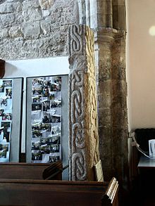
- Crowle Stone
-
The Anglo-Saxon sculpted Crowle Stone is at the back of the Church of England parish church of St Oswald at Crowle, Lincolnshire.[1][2]
This was originally carved as a cross shaft and until 1919 it was used as a lintel over the west door.[2][1] The preservation of the stone is almost certainly as a result of the Norman masons reusing it when the church was built in 1150.[3]
The stone measures 6'11" (2.11m) in height 16" (400mm) thick and 8.5" (215mm) wide.
The stone is ornately carved on all three sides. At the bottom of one face there is a runic inscription which would date the cross shaft as being before 950 as the use of runes had almost completely died out by then.
References
- ^ a b "National monument record:Stone". http://www.pastscape.org.uk/hob.aspx?hob_id=59280.
- ^ a b Fowler, J.T. (1868). Proceedings of the Society of Antiquaries of London (4): 187,378–9.
- ^ "National monument record:Church". http://www.pastscape.org.uk/hob.aspx?hob_id=59287.
- Further information can be found at: [1]
- A photo can be found here: [2][dead link]
- Images of the stone can also be found in Durham University's Corpus of Anglo-Saxon Stone Sculpture:[3]
- Pevsner, Nikolaus; Harris, John (23 Nov 1989). Antram, Nicholas. ed. Lincolnshire. The Buildings of England (2 ed.). Pevsner Architectural Guides. ISBN 978-0140710274.
Coordinates: 53°36′28″N 0°50′07″W / 53.6077°N 0.8352°W
Anglo-Saxon Bewcastle Cross · Crowle Stone · Dartmoor crosses · Easby Cross · Gosforth Cross · Legg's cross · Ruthwell Cross · Sandbach Crosses · Sheffield CrossIrish Ardboe High Cross · several at Clonmacnoise · Iona Abbey · Kildalton Cross · Muiredach's High Cross · St. Tola's Cross · several at TuamPictish Cornish Categories:- Anglo-Saxon archaeology
- Archaeological sites in Lincolnshire
- High crosses
- History of Lincolnshire
- Monuments and memorials in England
- Monumental crosses in the United Kingdom
Wikimedia Foundation. 2010.

