- Coleby, North Kesteven
-
Coordinates: 53°08′01″N 0°32′15″W / 53.133715°N 0.53758979°W
Coleby 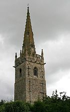
All Saints' church, Coleby
 Coleby
Coleby shown within LincolnshireOS grid reference SK 97937 60616 District North Kesteven Shire county Lincolnshire Region East Midlands Country England Sovereign state United Kingdom Post town Lincoln Postcode district LN5 Police Lincolnshire Fire Lincolnshire Ambulance East Midlands EU Parliament East Midlands UK Parliament Sleaford and North Hykeham List of places: UK • England • Lincolnshire Coleby is a village and civil parish in the North Kesteven district of Lincolnshire, England. It lies on the A607 approximately 6 miles (9.7 km) south of Lincoln.
The village, a documented settlement in Domesday, is set on the Lincoln Cliff escarpment with views over the River Witham valley from its western side. The Viking Way, the 146 miles (235 km) long-distance footpath from the Humber Bridge to Oakham, passes through the village. Coleby's population is approximately 600.[citation needed]
Coleby Grade I listed Anglican parish church is dedicated to All Saints.[1] The original church was built by the Anglo-Saxons, extended by the Normans and had a new spire built on top of the Saxon tower in the Middle Ages.[citation needed] There is a lack of symmetry to the chancel, the arches on the north and south walls do not match and half of an arch has been stopped off. The pews inside the church are not original, they come from a former church at Hackthorn, a village about 14 miles (23 km) to the north, as do two of the windows in the north aisle.[citation needed] The church was also extensively restored in 1900. On the church steeple are landing lights for the nearby RAF Waddington airbase.[citation needed]
Near the Church in a park of around 50 acres (20 ha) stands Coleby Hall, a gabled house dating back to 1628, built for Sir William Lister, the father of Thomas Lister. The gateway to the Hall is an imitation ruined Roman arch based upon Newport Arch in Lincoln. Standing in the grounds is folly of a Temple to Romulus and Remus which was built in 1762.[citation needed]
Coleby has two village pubs, The Bell situated close to the church, and the Tempest Arms which stands at the top of the road that leads up the hill from the valley.
The village has small school usually consisting of below 100 pupils.
Contents
RAF Coleby Grange
Main article: RAF Coleby Grange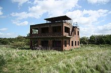 The derelict control tower at RAF Coleby Grange
During the Second World War, the Ministry of Defence constructed an airfield at RAF Coleby Grange to the east of the village on open heathland, immediately west of the A15 road. It opened in 1939 with grass runways as a relief landing ground for RAF Cranwell. In May 1941 it was transferred to 12 Group, RAF Fighter Command and became a satellite station for RAF Digby.
The station re-opened in 1959 as a Thor IRBM launching base, it closed again in 1963. Today the airfield is in private hands and used for agriculture with only the Control Tower, which still stands although in a ruined state, as a visible sign of the station's existence.[2]
References
- ^ "All Saints church", National Heritage List for England, English Heritage; retrieved 18 July 2011
- ^ "Coleby Grange airfield", controltowers.co.uk: RAF Coleby Grange
Further reading
- Halpenny, Bruce Barrymore, Action Stations: Wartime Military Airfields of Lincolnshire and the East Midlands v. 2. ISBN 978-0850594843
External links
 Media related to Coleby, North Kesteven at Wikimedia CommonsCategories:
- Villages in Lincolnshire
- Civil parishes in Lincolnshire


Wikimedia Foundation. 2010.