- Uttara Kannada
-
North Kanara — district — Coordinates 14°36′N 74°42′E / 14.6°N 74.7°ECoordinates: 14°36′N 74°42′E / 14.6°N 74.7°E Country India State Karnataka Subdistrict(s) Karwar, Ankola, Kumta, Honnavar, Bhatkal, Sirsi, Haliyal, Mundgod, Yellapur, Siddapur, Joida Headquarters Karwar Deputy Commissioner B N Krishnaiah Population
• Density
1,353,644[1][2] (2001[update])
• 132 /km2 (342 /sq mi)
Sex ratio 971 ♂/♀ Literacy
• Male
• Female76.6[3]%
• 84.5%
• 68.5%Time zone IST (UTC+05:30) Area
• Coastline
10,250 square kilometres (3,960 sq mi)
• 140 kilometres (87 mi)
Climate
• Precipitation
Temperature
• Summer
• Winter
• 2,835 mm (111.6 in)
• 33 °C (91 °F)
• 20 °C (68 °F)Uttara Kannada also known as North Canara or North Kanara, is a district in the southern Indian state of Karnataka. It is bordered by the state of Goa and Belgaum District to the north, Dharwad District and Haveri District to the east, Shimoga District and Udupi District to the south and the Arabian Sea to the west.[2] The city of Karwar is the administrative headquarters of the district.
Contents
History
Uttara Kannada was the home of the Kadamba kingdom from the 350 - 525CE. They ruled from Banavasi. After the subjugation of the Kadambas by the Chalukyas, Uttara Kannada district came under successive rule of empires like Chalukyas, Rashtrakutas, Hoysalas and Vijayanagar empire.
Famous Arab traveler Ibn Battuta is said to have stayed for a time in the district under the protection of Nawayath Sultan Jamal al-Din at Hunnur. This place is presently known as Hosapattana and is located in the Honnavar taluka. Ruins of an old mosque and its minaret can still be seen in the village.
The district came under the rule of Maratha empire from around 1700 CE. to 1800 CE. It was ceded to the British at the conclusion of the Third Anglo-Maratha War in 1818. The British established North Kanara district as a part of the Bombay Presidency. After India's independence in 1947, Bombay Presidency was reconstituted as Bombay State. In 1956 the southern portion of Bombay state was added to Mysore State, which was renamed Karnataka in 1972.
Geography and climate
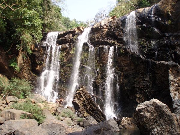
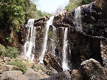 Satoddi Falls Yellapur
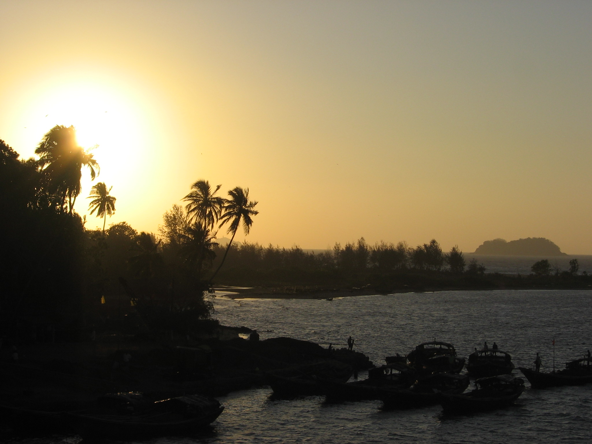
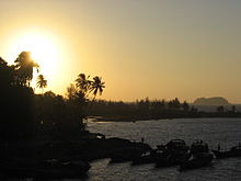 Karwar Evening
The main geographic feature of the district is the Western Ghats or Sahyadri range, which runs from north to south through the district. Between the Sahyadris and the sea is a narrow coastal strip, known as the Payanghat, which varies from 8 to 24 km in width. Behind the coastal plain are flat-topped hills from 60 to 100 meters in height, and behind the hills are the ridges and peaks of the Sahyadris. East of the Sahyadris is the Balaghat upland, part of the vast Deccan plateau.
Moisture-bearing winds come from the west, and yearly rainfall averages 3000 mm on the coast, and as high as 5000 mm on the west-facing slopes of the Sahyadris. East of the crest is the rain shadow of the Sahyadris, which receive as little as 1000 mm annually. Much of the rain falls in the June–September monsoon.
Four principal rivers drain westwards from the crest of the Sahyadris to the sea; from north to south they are the Kali, Gungawali, Aghanashini and Sharavati. These rivers form numerous waterfalls, the most famous of which is Jog falls, on upper reaches of the Sharavati in neighboring Shimoga district. Other famous waterfalls include Unchalli Falls, where the river Aghanashini drops 116 meters, Magod Falls, where the Bedti river plunges 180 meters in two leaps, Shivganga falls, where the river Sonda (Shalmali) drops 74 meters, and Lalguli falls and Mailmane falls on the river Kali. In the lowlands, these rivers form wide estuaries, extending several kilometers inland from the coast.
Ecology
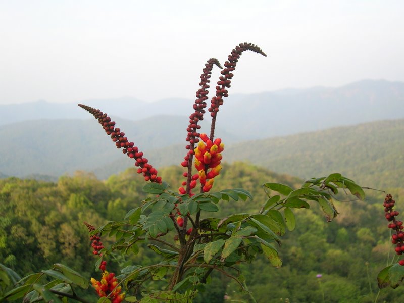
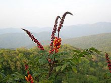 Candy Corn Plant (Wagatea spicata) in the Anshi National Park
The district's high rainfall supports lush forests, which cover approximately 70% of the district. The North Western Ghats moist deciduous forests cover the Sahyadris below 1000 meters elevation. Many trees shed leaves in the drier months. In pockets above 1000 meters elevation lie the evergreen North Western Ghats montane rain forests. Anshi National Park near Dandeli, preserves approximately 250 km² of semi-evergreen forest, which is home to the tiger, black panther, leopard cat, gaur, Asian Elephant, sambar and a range of birds and reptiles. Dandeli Wildlife Sanctuary protects 834 km² of semi-evergreen and bamboo forest in the watershed of the Kali river and its tributaries, the Kaneri and Nagajhari. The Wroughton free tailed bat is endemic to the forests of Bhimgad, a proposed wild life sanctuary.
The district is also home to patches of savanna and degraded scrub jungles, which are often the result of overuse for logging or grazing. Much of the lowland has been cleared for agriculture. Mangrove forests can be found in the river estuaries, and the sandy beaches are home to groves of Calophyllum inophyllum, coconut and screw pine (Pandanus spp.). The rocky beaches at Binaga, Arga, Belekeri, Tadadi, Ankola Keni, Kadle, Kumta, Dhareshwar, Kasarkod, Murdeshwar, Bhatkal and Belke of the district are rich with marine fauna diversity. The rocky beaches of Uttara Kannada District harbours the invertebrates belonging to the Phylum Porifera, Coelenterata, Annelida, Arthropoda, Mollusca and Echinodermata.
Attiveri bird sanctuary is home to 79 species of birds including migratory birds from 22 countries. Dandeli Wildlife Sanctuary is famous for the elusive black panther among other animals like Gaur, Tiger and Leopards. The Kavala caves with their 5 ft. high natural Shiva linga, Synthery rocks is a 500 ft high rock flanked by natural caves and waterfalls, Vincholi rapids, Sykes point which offers a view of Kali river, and a suspension bridge are places worth visiting in this sanctuary. Yana is an enchanting place that can be reached by trekking about 10 km through lush forest. Yana is famous for its tall jagged rock formations and waterfalls. There is also a shrine of Bhairaveshvara here. Anshi National Park located some distance from Dandeli is undisturbed. Burude Falls is about 20 km from Siddapur , Unchalli Falls, Shivagangae, BeeneHolae Falls is about 25 km from Sirsi, Magod Falls and Sathodi Falls near Yellapura are some of the best natural falls in Uttara Kannada District. There are many dams in this district namely Supa Dam, Kodasalli Dam and Kadra Dam. The famous Atomic energy station at Kaiga is on the beautiful banks of river Kali.
Economy
Agriculture
The chief crops of the district are rice and sugarcane, along with a great diversity of other crops. Tree crops include coconut, arecanut, cocoa, cashew, mango, banana, pineapple, Garcinia, and sapota; vegetables include onion, radish, cucumber, cauliflower, sweet potato, brinjal, and amaranth; spices include pepper, cardamom, ginger and nutmeg. Millet and cotton are grown in the drier portion of the district east of the Western Ghats.
Industries
The major products of small scale industries in Uttara Kannada are roofing tiles, coir products, jewelry, food products, wood and steel furniture, glass and ceramics and seafood. Some of these SSI and tiny industries provide job works, components and spares required for large and medium scale industries, both within and outside the district. Eight large and medium scale industries in the district produce a variety of products like paper, duplex board, caustic soda, ferro alloys, transmission gears, food concentrate, herbal medicines and pharmaceuticals.
Towns
Demographics
According to the 2011 census Uttara Kannada has a population of 1,436,847 ,[4] roughly equal to the nation of Swaziland[5] or the US state of Hawaii.[6] This gives it a ranking of 346th in India (out of a total of 640).[4] The district has a population density of 140 inhabitants per square kilometre (360 /sq mi) .[4] Its population growth rate over the decade 2001-2011 was 6.15 %.[4] Uttara Kannada has a sex ratio of 975 females for every 1000 males,[4] and a literacy rate of 84.03 %.[4]
Culture
The languages of the Uttara Kannada district are Konkani, Marathi and Kannada. Kannada is the predominant language spoken in the district followed by Konkani which are also widely spoken.Marathi is also spoken here. The population is predominantly Hindu composed of majority communities Namadhari, Havyaka, Grama Vokkaligas, Halakki Vokkaligas, Goud Saraswat and minority communities Bhandari, Mogaveera, Komarapant, Ager, Chamagara, Konkan Maratha , Nadavara, Chitrapur Saraswat, Daivajna, Shervegar(Ramakshatriya), Devadasi, Harikant, Gabeet, Kharvee, Gudigara and Vani. Christians of Catholic and Protestant faiths and Islams are thinly spread out in Uttara Kannada. The community of Islam living in Bhatkal and Kumta are known as Nawayaths. The people of Uttara Kannada are non-vegetarians except for Havyaka community. Fish and coconut are common in their diet.
Dance
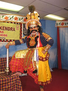
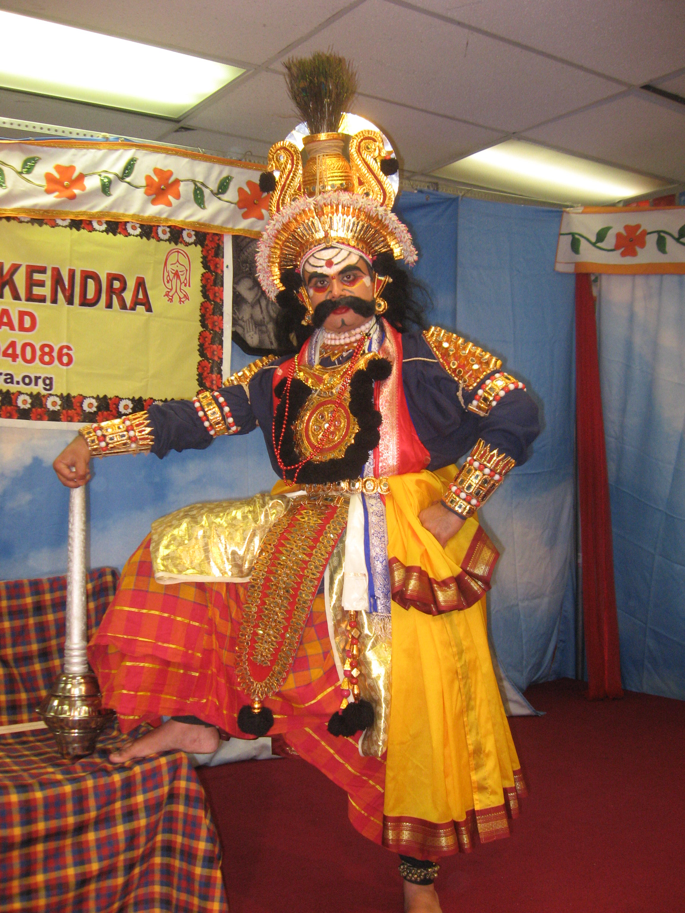
Yakshagana is a dance drama popular in the district of North Karnataka. It is believed to have evolved from pre classical music form and theatrical arts.[7] Yakshagana is popular in the districts of North Kanara, Shivamogga, Udupi, Dakshina Kannada and Kasaragod district of Kerala.[8] This would be considered to be a form of opera in western eyes. Actors wear costumes and enact the various roles. Traditionally, Yakshaganas would go on all night. It is sometimes simply called as Aataā in both Kannada and Tulu (meaning play).[8] Yaksha-gana literally means the song (gana) of a Yaksha. Yakshas were an exotic tribe mentioned in the Sanskrit literature of ancient India.[9]
Newspapers and media
- The District Media/News Center (Zilla Varta Kendra) is located near DC office Karwar.
- SahilOnline English Urdu & Kannada daily from Bhatkal.
- Karavali Munjavu from Karwar.
- Nagarika from Honavar.
- NudiJenu from Ankola by B.Honnappa
- Kanada Vruththaa from Kumta
- Pathrakartha from Sirsi
- Janamadhyama from Sirsi
- Lokadhwani from Sirsi
- www.sirsi.in
- janantharanga .Kumta
Transport
Public transport
North West Karnataka Trasport Corporation (NWKRTC) is the state transport agency in the district. The NWKRTC covers all towns & villages of the district. There is a good network of public transport which connects the villages to the towns of the district. There is regular intra state services to major cities & towns of the state like Bangalore, Mysore, Mangalore, Hubli-Dharwad & Belgaum. The Kadama Transport buses of neighbouring Goa state provides regular service from Karwar to all part of Goa state. Kumta & Sirsi are the main hubs for public transport which provides services to intra-district & intrastate round the clock,
Many private transport buses also provide services for inter / intra state from the district. The NH-17 which passes through the district which connects Mumbai to Kerala state, many private buses are plying on this Highway which provides inter-intra state services to places like Mumbai, Pune, Kolhapur, Belagum, Udupi, Mangalore, Kasrgod & Kannur etc.
Highways
The following are the National Highways which passes through the district of Uttar Kannada.
- NH-17 Which connects Edappally near Ernakulam in Kerala and Panvel near Mumbai, Which start in the north of the district at Majali village & ends at Bhatkal.
- NH-206 Which connects Honnavar and Bengaluru
- NH-63 Which connects Ankola and Hubli
- NH-17A Which connects Dandeli and Vasco
Railways
The following Railways pass through the district:
- Konkan Railway Which connects Mangalore and Mumbai via Karwar,
- Londa to 'Vasco Railway line which passes through 'Castle Rock'
- Casle Rock to Dandeli Railway line.
- Hubli -Ankola railway line is proposed to link Karwar port and the northern Karnataka.
- RO-RO (Roll on/Roll off) services is provided by Konkan Railway to / from Ankola railway station to Suratkal Railway station. Many truckers use this facility between Ankola to Mangalore.
Ports
Uttar Kannada being one of the coastal district of the Karnataka state has a coast of 120 km has many ports which are used for Sea Trade, Naval base, Fishing & other maritime activities.
- KARWAR PORT is an intermediate sea port the main activities of this port are Berthing of Ocean Going Ships, Coastal Shipping, & Fishing Jetty. Ship bunkering facility is also available at Karwar port.
- INS KADAMBA is a naval base at Arga village of Karwar which is used excusively for berthing of Naval vessels. A naval ship repair yard (Dry Docks) is also attached to it.
- BELEKERI PORT is an anchorage port.
- TADRI PORT is a fishing port.
- HONNAVOR PORT is a fishing port.
- BHATKAL PORT it is a fishing port.
The Proposed Hubli-Ankola railway line can be feasible venture for the future developments of the ports in the district, for movement of the cargo, at present roads are only major mode of cargo movement which leads to congestion of the National Highways of the district.
Nearby airports
- Hubli Airport
- Goa International airport
- Belgaum airport
- Mangalore International Airport
Education
High schools and colleges
- Karwar
- Arts and science college, Karwar
- Hindu High School, Karwar]].
- Government High School, Karwar
- Government polytechnic, Karwar
- Shivaji High School, Karwar
- Shivaji Girls High School, Karwar
- Shivaji Degree College, Karwar
- Shivaji B.Ed College, Karwar
- Divekar College of Commerce, Karwar
- Sri Somnath Highschool Binaga, Karwar
- New High School, Karwar
- St. Joseph's High School, Karwar
- St. Michael's High School, Karwar
- Sadashivgad High School, Karwar
- Unity High School, Karwar
- Swami Vivekananda High School, Karwar
- Unity High School, Karwar
- Shivaji Teachers Training institute (D.Ed), Karwar
- Modern High School, Halga Karwar
- Sri shivaji secondary school, Ulga Karwar
- Sri Mahasatee Pre-University college Ulga Karwar
- Sri Mahasatee Arts, commerce and Science Degree College Ulga Karwar
- B.G.V.S.Arts and commerce college,Sadashivgad,Karwar
- Ankola
- GCCollege Ankola|G. C. College]], Ankola
- Jai Hind High school (Edwards), Ankola
- Peoples Multi-purpose High School, Ankola
- Nirmala Hridaya High School, Ankola
- Nirmala Hridaya English medium school, Ankola
- Kumta
- Pragathi vidyalaya]]
- Govt First grade college, kumta
- S V Polytechnic, kumta
- Indian Institute of Science,IISc, field station
- St John Baptist convent,nirmala convent
- Anandashram High School, Bankikodla
- Dr. A. V. Baliga college, Kumta
- Gibbs High School, Kumta
- Bhadrakali High School, Gokarna]]
- Shri Sadguru Nityanand High-School, Sanikatta
- Ideal School, Kumta
- Shri Shantikamba High School Hegde,Kumta
- Shri Babrulingeshwara High School Lukkeri/Masur,Kumta
- Kendriya Vidyalaya, BGS kumta
- Yellapur
- Shree Raja Rajeshwari High School, Manchikeri
- Y.T.S.S High School, Yellapur
- pragathi vidyalaya bharatanahalli,yellapura
- Sirsi
- College of forestry, UAS(D).
- Shri Marikamba High School, Sirsi
- MES's M. M. College of Arts and Science, Sirsi
- avemaria school and high school
- progressive school and high school and
many govt school and colleges.
- Siddapur
- Dhanvantari Ayurvedic Medical College, Siddapur
- Mahatma Gandhi College of Arts and Science, Siddapur
- Prashanti High school, Siddapur
- Honnavar
- Arts and Science college, Honnavar
- St.Thomas School, Honnavar
- Government High School, Jalvala karki
- Sri Subramanya P.U. collage Kavalakki
- Government High School, Hadinadala
- Government P.U Collage, Idagunji
- Holy Rosary Convent School, Honnavar
- Janatha Vidyalaya Composite Junior College Kadatoka
- Other
- Santeri High School, Hankon
- Janata Vidyalaya, Dandeli
- Shri Jagadamba High School, Sarkuli
- Shri Mahaganapathi High School, Kibballi
- V. R. Deshpande Rural Institute of Technology at Haliyal
- Sri SitaRamachandra (SR) High School, Bilagi
- Bhatkal
- The New English School Bhatkal
- The New English Pre University College Bhatkal
- Shree Guru Sudhindra College Bhatkal
- Shree Guru Sudhindra BBA College Bhatkal
- Shree Guru Sudhindra BCA college Bhatkal
- Shree Jnaaneshwari College of Education (B.Ed) Bhatkal
- Shree Jnaaneshwari College of Education (M.Ed) Bhatkal
- VidyaBharati English Medium School Bhatkal
- Vidyanjali Public School (CICSE Syllabus) Bhatkal
- H.H.Swami Parijnanashram College of Education(D.Ed) Bhatkal
- Anjuman Engineering College, Bhatkal
- Anjuman Arts, science, and Commerce college, Bhatkal
- Anjuman Institute of Management, Bhatkal
- Islamia Anglo Urdu High School, Bhatkal
- Anjuman Girls High School, Bhatkal
- National High school, Murdeshwar, Bhatkal
- Shams English medium high school, Bhatkal
- Naunihal central school, Bhatkal
Notable people from the district
Categories:- Districts of Karnataka
- Uttara Kannada district


Wikimedia Foundation. 2010.