- Kumta
-
Kumta
कुम्ता
کم ٹا— town — Coordinates 14°25′00″N 74°24′00″E / 14.4167°N 74.4°ECoordinates: 14°25′00″N 74°24′00″E / 14.4167°N 74.4°E Country India Region Coastal State Karnataka District(s) North Kanara Population
• Density
32,598 (2011[update])
• 1,957.2 /km2 (5,069 /sq mi)
Official languages Konkani and Urdu Time zone IST (UTC+05:30) Area
14.86 square kilometres (5.74 sq mi)
• 2 metres (6.6 ft)
Kumta (Konkani: कुम्ता, Urdu: کم ٹا ) is a town and a taluka in North Kanara district in the Indian state of Karnataka. It is a coastal town and is about 142 km south of the city Margao and 58 km north of Bhatkal.
Contents
History
During the British Raj, it was a part of the North Kanara district of Bombay Presidency. Crafts made out of Carving in sandalwood is a speciality.
The town of Kumta is located on the Arabian sea coast in the district of North Kanara in the state of Karnataka. During the American Civil War the cotton from the southern states that fed mills in England stopped supplying and the mills started importing a variety of cotton known as 'Kumta Hatti' this resulted in development of Kumta port.
Just to the north of town, the Agnashini river joins the Arabian Sea on her way rendering stunning scenery. A nearby rock climbing spot called Yana is also beautiful with its massive black rock formations and nature trails. The town of Gokarna, near Kumta is famous for beaches.
The town of Kumta features diverse population including Muslims (Nawayath), Christians, Havyakas, Gudigars, haalakki and Fishermen Beaches, lakes (Vishnuteerth), and mountains provide a lot of recreational opportunities to the locals.
Geography
Kumta is located at coastal region of India. It has an average elevation of 3 metres (9 feet).
Qiblah direction for Muslim Prayers:-287.9223 from north clockwise
Kumta is adjacent to the vast western ghats. Aghanashini is the major river of Kumta taluk. There are many tourist places nearby Kumta. Gokarna, famous for the its beach is just 30 km. Yana is just 20 km from Kumta.
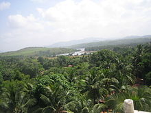 Kumta scenery with a view of Aghnashini river
Places around Kumta include:
- Gokarna beaches,
- Kumta beach,
- Kadle Beach
- Holanagadde Nene Beach,
- Tue Beach,
- Dhareshwar beach,
- Baada temple and beach,
- Mirjan Fort,
- Chandavar Fort,
Demographics
As of 2011[update] India census, Kumta had a population of 32,598. Males constitute 51% of the population and females 49%. Kumta has an average literacy rate of 77%, higher than the national average of 59.5%: male literacy is 82%, and female literacy is 73%. In Kumta, 10% of the population is under 6 years of age. Konkani and Nawayathi is widly spoken by people of Kumta and Hindi is also spoken here.
The Muslims [Nawayath] and the Hindus communities are predominant in Kumta. The people of Kumta have since the 1960s spread afar, including UK, America, Australia but more so across the Middle East especially Bahrain, Dubai, Oman, Qatar, Saudi. Nawayati is the most widely spoken language of the town.
The Kumta Nawayath is known as owned business like Garment showroom, House material, Real Estate , Hotel , Super Market,Construction Business, Other Engineering Industries, Whole Seller of Import item,travel.etc
Climate
This part of Karnataka has very hot summer with temperature rising of maximum of 35-36 degree Celsius and a very heavy rainfalls in rainy season. The impact of winter is less in this part of coastal Karnataka. Since the town is located on the coast, it has a extreme climate, with temperatures in the range of 360C to 280C during summer and 260C to 200C during winter. The rainy season witnesses heavy rains by the South-West Monsoon. The average annual rainfall is about 3000 mm.
Economy
Kumta is known for its coconut, bettelnut, cashew, spices like pepper, turmeric, banana cultivations and fisheries. But the most significant produce is arecanut and betel leaves. It has its very own arecanut trading centre and shandy market at APMC.
Educational institutes of Kumta taluk
Kumta town has been a pioneer learning center in the North Kanara District for many years.
Educational institutes of Kumta taluk
- St John Baptist Nirmala Convent School,
- Gibb High School,
- Konkan Educaton Trust,
- Ideal Urdu School,
- Dr. A.V.Baliga College Of Arts & Science,
- Dr. A.V.Baliga College Of Commerce,
- Govt First Grade College,
- Indian Institute Of Science,IISc, Field Station,
- Mahatma Gandhi High School,
- Jawahar Navodaya Vidyalaya,
- Bhadrakali High School,
- Kendriya Vidyalaya, BGS
- Pragathi Vidyalaya,
- Saraswati Teachers Training College,
- Shree Vidyadhiraj Polytechnic,
- Shri Sadguru Nityanand High-School,
- Shri Shantikamba High School,
- Shri Babrulingeshwara High School,
Transportation
Road
National highway 17 passes through Kumta. It connects Kumta with Panvel, Edapally, Mumbai, Panjim, Margao, Karwar, Bhatkal, Mangalore and Ernakulam. It can be reached by even state highways connecting Kumta to Sirsi and to Hubli via Yellapur.
Rail
- Kumta [KT] is well connected through Konkan railways which has rails plying from Mumbai, Panjim, Margao towards Mangalore (Mangalore Central [MAQ] and Mangalore Junction [MAJN]), Kumbakonam and also vice versa. The railway station is very near to town situated about a kilometre away from national highway.
Air
- Nearest airports are Goa International Airport. Goa airport is about 156 km from Kumta.
From other cities in India
- Kumta is 80 km from Goan border (Polem) and 2 hour by train from Margao, 10 hours by bus from Bangalore and 13 hours by train from Mumbai on Konkan Railway route.
- Kumta is 177 kilometres from Panaji (Goa), 459 kilometres from Bangalore, 60 kilometers from Sirsi, 806 kilometres from Chennai, 698 kilometres from Mumbai, 208 km from Mangalore.
Place Distance from Kumta (in km) State Margao 142 Goa Bangalore 459 Karnataka Hubli 157 Karnataka Mangalore 208 Karnataka Mumbai 698 Maharastra Karwar 68 Karnataka Sirsi 60 Karnataka Bhatkal 58 Karnataka Panjim 177 Goa Canacona 106 Goa Polem (Goa Border) 90 Karnataka-Goa Border Vasco-da-gama 172 Goa Udupi 147 karnataka Belgaum 220 Karnataka Dandeli 152 Karnataka Ankola 38 Karnataka Dharwad 165 Karnataka Verna 152 Goa Chennai 807 Tamil Nadu Trivandrum 826 Kerala Pune 549 Maharastra Thrissur 561 Kerala Kasaragod 250 Kerala Honnavar 20 Karnataka Hyderabad 665 Andhra Pradesh Geography

Arabian Sea Goa Hubli Arabian Sea 
Sirsi  Kumta
Kumta 

Arabian Sea Bhatkal Sagar North Kanara Taluks Tourist places Gokarna · Yana · Banavasi · Idagunji · Murudeshwar · Dandeli · Netrani Island
Jog Falls · Magod Falls · Sathodi Falls · Unchalli FallsSee also Project Seabird · Supa Dam · Kali River · Sharavathi River · Western Ghats · Konkani people
Categories:- Railway stations on Konkan Railway


Wikimedia Foundation. 2010.