- Chitradurga district
-
This article is about the district. For its eponymous headquarters, see Chitradurga.
Chitradurga district
ಚಿತ್ರದುರ್ಗ ಜಿಲ್ಲೆ
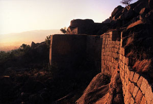
— district — Chitradurga Fort
Coordinates 14°00′N 76°30′E / 14.00°N 76.50°ECoordinates: 14°00′N 76°30′E / 14.00°N 76.50°E Country India State Karnataka Division Bangalore Division Subdistrict(s) Chitradurga, Hiriyur, Hosdurga, Molakalmuru, Challakere, Holalkere Headquarters Chitradurga Deputy Commissioner Amlan Biswas IAS Member of Parliament Janardhana Swamy Parliamentary constituency Chitradurga Lok Sabha constituency Population
1,517,896[1] (2001[update])
• 180 /km2 (466 /sq mi)
• 18.1Sex ratio 1.047 ♂/♀ Literacy
• Male
• Female64.5%
• 74.7%
• 53.8%Official languages Kannada Time zone IST (UTC+05:30) Area 8,440 square kilometres (3,260 sq mi)[1] Climate
• 522 mm (20.6 in)
ISO 3166-2 IN-KA-CT  Portal: Karnataka
 Website chitradurga.nic.in Chitradurga district (Kannada: ಚಿತ್ರದುರ್ಗ ಜಿಲ್ಲೆ) is an administrative district of Karnataka state in southern India. The city of Chitradurga is the district headquarters. Chitradurga gets its name from Chitrakaldurga[citation needed], an umbrella-shaped lofty hill found there. Tradition dates Chitradurga District to the period of the Ramayana and Mahabharata. The whole district lies in the valley of the Vedavati River, with the Tungabhadra River flowing in the northwest. During the British times it was named Chitaldroog[citation needed]. The district was practically ruled by all the well known dynasties that ruled Karnataka.
Contents
Demographics
The population was 1,517,896, of which 18.07% were urban as of 2001 comprising Lingayats, Devangas, Nayakas, Gollas (Yadavs), Kurubas, Madiga, Bhovi and several other communities.Majority of the people in Chitradurga are Hindus with Muslims comprising about 9% of the population. Kannada is the most widely spoken language but Telugu is also spoken near areas bordering Andhra Pradesh.
Geography
The district is hilly, with lots of forts and villages. The district is bounded by Tumkur District to the southeast and south, Chikmagalur District to the southwest, Davanagere District to the west, Bellary District to the north, and Anantapur District of Andhra Pradesh state to the east. Davanagere District was formerly part of Chitradurga. The district is divided into taluks, namely Chitradurga, Hiriyur, Hosadurga, Holalkere, Challakere and Molakalmuru. It is rich in mineral deposits, including gold prospecting at Halekal, Kotemardi or Bedimaradi, etc., and open cast copper mines at Ingaldhal.
History and Legends
Chitradurga features bold rock hills and picturesque valleys, huge towering boulders in unimaginable shapes. It is known as the "stone fortress" (Kallina Kote). The landscape looks much like a mischievous giant's playground, with boulders thrown around, forming silhouettes against the sky. According to a story in the Epic Mahabharatha, a man-eating giant named Hidimbasura lived on the Chitradurga hill and was a source of terror to everyone around. When the Pandavas came with their mother Kunti in the course of their exile, Bhima had a duel with Hidimba. Hidimba was slain by Bhima and peace returned to the area. Legend has it the boulders were part of the arsenal used during that duel. In fact, the boulders on which major part of the city rests belong to the oldest rock formation in the country.
Timmana Nayaka a chieften under the Vijayanagar empire rose to the rank of governor of Chitradurga as a reward for his excellence in military achievements, from the Vijayanagara ruler. This was the beginning of the rule of the Nayakas of Chitradurga. His son Obana Nayaka is known by the name Madakari Nayaka 1588 CE. Madakari Nayaka's son Kasturi Rangappa 1602 succeeded him and consolidated the kingdom to rule peacefully. As he had no heirs to succeed him, his adopted son, the apparent heir was enthroned but was killed in few months by the Dalavayis.
Chikkanna Nayaka 1676, the brother of Madakari Nayaka II sat on the throne, and his brother succeeded him with the title Madakari Nayaka III in 1686. The unwillingness of Dalawayis to accept Madakari Nayaka III's rule gave an opportunity to one of their distant relatives, Bharamappa Nayaka to ascend the throne in 1689. He is known as dthe greatest of the Nayaka rulers. Somehow, the subjects of Chitradurga did not experience a good reign of the successive rulers as they ruled on the throne for very brief periods. The Hiri Madakari Nayaka IV 1721, Kasturi Rangappa Nayaka II 1748, Madakari Nayaka V 1758 ruled this area but there is not much to mention of their rule.
Battle with Hyder Ali, Legend of Obavva
During the reign of Madakari Nayaka, the city of Chitradurga was besieged by the troops of Hyder Ali. A chance sighting of a woman entering the Chitradurga fort through an opening in the rocks led to a clever plan by Hyder Ali to send his soldiers through the hole. The guard on duty near that hole had gone home for lunch and asked his wife to be on guard until he was back. The wife of that guard, Obavva while in her temporary seat, noticed soldiers emerging out of this opening. Obavva was not perturbed. She was carrying with her an Onake (a long wooden club meant for pounding paddy grains). She killed Hyder Ali's soldiers one by one as they attempted to enter the fort through the opening and quietly moved the dead. Over a short period of time hundreds of soldiers entered and fell, without raising any suspicion. Obavva's husband, upon his return from his lunch was shocked to see Obavva standing with a blood stained Onake and hundreds of dead bodies of the enemy around her. The opening in the rocks still remains as a historical witness for the story, beside the Tanniru doni a small water source which holds cold water all round the year. Though her sincere and brave attempt saved the fort on that occasion, Madakari Nayaka could not repel Hyder Ali's attack in 1779. In the ensuing battle, the fort of Chitradurga was lost to Hyder Ali. Obavva, like Kittur Rani Chennamma remains a legend, especially to the woman of Karnataka.
The Fort (ಏಳು ಸುತ್ತಿನ ಕೋಟೆ )
Chitradurga Fort is renowned for its name Kallina Kote / Ukinna kote / Elu Suttina kote in Kannada, which was built in parts by the Palegar Nayakas, Hyder Ali and Tipu Sultan. It comprises a series of seven enclosure walls. Eighteen ancient temples can be found inside the fort. This seemingly impregnable
fort has 19 gateways, 38 posterior entrances, a palace, a mosque, granaries, oil pits, four secret entrances and water tanks. The rulers of this fort built 2000 watch towers to guard and have a better look at enemies movement all the time.
Culture under Palegaras
Known for their valour, Chitradurga's Nayaka Palegaras were also patrons of great musicians. Writer Ta. Ra. Su (T.R. Subba Rao) has not only researched extensively in the area but has brought to life several characters who lived in those times in the fortified city. Several films (notably Nagara Haavu, Hamsa Geete and KallaraLi Huvaagi have brought to life the glory of this fort).
Location
Accessible by road, this fortress lies on the outskirts of what is Chitradurga today. The city of Chitradurga is located at the junction of NH-4 (Bangalore-Pune National Highway) and NH-13 (Sollapur-Mangalore National Highway). Chitradurga is also accessible by train. There is a daily service to Bangalore and weekly services to Mumbai. Proposed link between Chitradurga and Tumkur can reduce the travel time to Bangalore by half.
Economy
In 2006 the Ministry of Panchayati Raj named Chitradurga one of the country's 250 most backward districts (out of a total of 640).[2] It is one of the five districts in Karnataka currently receiving funds from the Backward Regions Grant Fund Programme (BRGF).[2]
Demographics
According to the 2011 census Chitradurga district has a population of 1,660,378,[3] roughly equal to the nation of Guinea-Bissau[4] or the US state of Idaho.[5] This gives it a ranking of 297th in India (out of a total of 640).[3] The district has a population density of 197 inhabitants per square kilometre (510 /sq mi) .[3] Its population growth rate over the decade 2001-2011 was 9.39 %.[3] Chitradurga has a sex ratio of 969 females for every 1000 males,[3] and a literacy rate of 73.82 %.[3]
Famous people
- Madakari Nayaka — Ruler of Chitradurga
- Bichugatti Baramanna Nayaka
- Onake Obavva — Legendary woman who fought Hyder Ali's army.
- Malladihalli Sri Raghavendra Swamiji (Tiruka) — a Great Yoga and Ayurvedic Guru
- S. Nijalingappa (vinayak) — politician, ex-CM, ex-MP and ex All India Congress leader
- Janardhana Swamy — Member of Parliament, 15th Lok Sabha, Chitradurga Parliamentary Constituency
- T.R. Subba Rao (TaRaSu) — a novelist, 1985 winner of Sahitya Akademi Award
- Venkata Subba Iyengar — musician on whom the movie Hamsageethe was made
- P.R. Thippeswamy (PRT) Artist, Writer & Folklorist - K. Venkatappa Awardee 1999, ex-Chairman Karnataka Lalithakala Academy
Places to Visit
Taralabalu Mata Sirigere Sirigere place from towards Chitradurga to Davanagere. Sirigere is situated on the Poona- Bangalore National Highway (NH4). It is at distance of 227 KM from Bangalore and is located between Chitradurga (27 KM), the District Head Quarters, and Davangere (50 KM). It can be easily recognized while travelling on the National Highway No.4 by the presence of an attractive arch on the western side. Sirigere is just 6 KM from this Arch.
Chitradurga Kote is a fort that is one of a kind, as it is built on top of hill with stones. Chitra-durg gets its name because of this fort. "Chitra durga" means "picture perfect".
Ashoka Siddapura is an important archaeological site where emperor Ashoka's edits were found. Nearby is Ramagiri, a hillock that has mythical associations with the epic Ramayana. A temple dedicated to Rameshwara built in 926 CE. exists here.
Brahmagiri village is the ancient site of Ishila, one of emperor Ashoka's provincial capitals. His earliest rock edicts in Brahmi script and Prakrit language (3rd c. BC) containing Kannada words were discovered here.
Chandravalli is an ancient archaeological site where painted pottery and coins from the Shatavahana empire and prehistoric times were discovered. The rock inscription of king Mayurasharma dated 450CE. discovered here gave historians much information about Karnataka's first Kannada kingdom.
Hiriyur situated on the right bank of Vedavathi river is famous for its Therumalleshawara temple. The temple has impressive lofty gopura and the ceiling of the main hall is painted with scenes from the Shivapurana and Ramayana.
Jogimatti Hill Station
Molakalmuru fortified town of the Kadambas
Neerthadi is famous for its Ranganathaswamy temple built in Vijayanagar style.
Vani Vilas Sagar (also known as Mari Kanive) an artificial lake built by the Mysore Maharaja across the river Vedavathi. The reservoir has two mantapas built in saracenic style.
- Gavirangapura 3 km from Srirampura Hosdurga taluk has a very well known temple of Sri Gavirangnatha swamy the Lord is in the form of kurma the second avatar of lord vishnu where most of the devotees are from Banglore belonging to Devanga community.It is one of the two temples of kurma avatara in India the other one is at Srikurmam 13 km from Srikakulam [A.P.]
Thamatekallu has ancient rock inscription and the oldest virgallu or hero stone inscription in Karnataka.
Holalkere is well known for its 10th century Jain settlement and 9 ft. tall statue of Bala Ganapathi, a child form of Hindu god Ganapathi.
Doddahottrangappa Hill has a Ranganathaswamy temple on top of a hillock which is a trekkers paradise.
Halu Rameshwara near Hosadurga is well known for the temple & wells, the well has white coloured water (looks like milk) in it that's why the name 'Halu' Rameshwara.
Harthikote a historical (Palegar's of Madakarinayaka ruled) village of Hiriyur taluk, Famous for 'Dana Jathra'. conducting every year in month of April. Veerabhadreshwara, Revanna Siddeshwara temples are famous here.
See also
References
- ^ a b "District at a Glance". Chitradurga district website. http://chitradurga.nic.in/stastics.html. Retrieved 3 January 2011.
- ^ a b Ministry of Panchayati Raj (September 8, 2009). "A Note on the Backward Regions Grant Fund Programme". National Institute of Rural Development. http://www.nird.org.in/brgf/doc/brgf_BackgroundNote.pdf. Retrieved September 27, 2011.
- ^ a b c d e f "District Census 2011". Census2011.co.in. 2011. http://www.census2011.co.in/district.php. Retrieved 2011-09-30.
- ^ US Directorate of Intelligence. "Country Comparison:Population". https://www.cia.gov/library/publications/the-world-factbook/rankorder/2119rank.html. Retrieved 2011-10-01. "Guinea-Bissau 1,596,677 July 2011 est."
- ^ "2010 Resident Population Data". U. S. Census Bureau. http://2010.census.gov/2010census/data/apportionment-pop-text.php. Retrieved 2011-09-30. "Idaho 1,567,582"
External links

Davanagere district Bellary district Anantapur district, Andhra Pradesh 
Tumkur district (Northern)  Chitradurga district

Chikmagalur district Tumkur district (Southern) Anantapur district, Andhra Pradesh  Districts of Karnataka
Bangalore Division Bangalore Urban · Bangalore Rural · Chitradurga · Davanagere · Kolar · Shimoga · Tumkur . Ramanagara. ChikkaballapurBelgaum Division Gulbarga Division Mysore Division  Settlements in Chitradurga district, KarnatakaDistrict HQ: Chitradurga
Villages and Towns Abbaiahnahalli · Abbinahole · Abradasikatte · Adanur · Adavi Sangenahalli · Adavigollarahalli · Adiralu · Adivala · Adrikatte · Agasarahalli · Agrahara (Holalkere) · Agrahara (Hosadurga) · Aimangala · Ajjappanahalli · Ajjikamasagara · Ajjikyatanahalli · Aladahalli · Alagatta · Alagavadi · Alaghatta · Alur · Amakundi · Amanahal · Amanitalav · Ambalagere · Amruthapura · Andanur · Anesidri · Anivala · Annehal · Anthapura · Apparasanahalli · Appasamudra · Arabagatta · Aralahalli · Aralihalli · Arasanaghatta · Arasinagundi · Arehalli · Arehalli · Arehalli Kaval · Arenahalli · Athimage · Attigatta · B.Durga · Babbur · Bachavara · Badavanahalli (B) · Badavanahalli Kaval (B) · Bagasettihalli · Bagenahal · Baggalurangavvanahalli · Bagganadu · Bagganadu Kaval · Bagur · Bahadurghatta · Balenahalli · Balenahalli · Balenahalli · Baligatte · Ballalasamudra · Ballalasamudra Kaval · Ballalasamudrakere Kaval · Ballekere · Banagere · Banapura · Banasihalli · Banavigondanahalli · Bande Bommenahalli · Bandethimmalapura · Bandravi · Banjagondanahalli · Banjigere · Baramasagara (B) · Basapura · Basapura · Basapura · Basavanashivanakere · Basavapura · Bastihalli · Bedarashivanakere · Beeravara · Beerenahalli · Beesanahalli · Belagere · Belagere Kaval · Belaghatta · Belagur · Benakanahalli · Benkanahalli · Bettadanagenahalli · Bevinahalli · Bevinahalli · Bhairanayakanahatti · Bharamagiri · Bharamapura · Bharamasagara · Bharamasagara · Bhatrahalli · Bheemagondanahalli · Bheemanakere · Bheemasamudra · Bhoganahalli · Bidarakere · Bidarakere · Bochapura · Bokikere · Bomberahalli · Bommadevarahalli · Bommagondanakere · Bommakkanahalli · Bommakkanahalli · Bommalinganahalli · Bommanakatte · Bommanakunte · Bommasamudra · Bommavvanagathihalli · Bommenahalli · Bommenahalli · Bommenahalli · Boranakunte · Borenahalli · Brahmapura · Budipura · Budnahatti · Bukkambudi · Bukkasagara · Buklorahalli · Burudekatte · Burujanaroppa · Byadarahalli · Byadareddyhalli · Byalahal · Byaramadu · Bydarahalli · Byrapura · Byrapura · Challakere (Rural) · Challamadu · Channammanagathihalli · Channapatna · Channasamudra · Channasamudra · Chattekamba · Cheelangi · Cheeranahalli · Chennaganahalli · Chikkaammanahalli · Chikkabadihalli · Chikkabbigere · Chikkabennur · Chikkabyladakere · Chikkachellur · Chikkagondanahalli · Chikkaguntanur · Chikkahalli · Chikkahullenahalli · Chikkajagalur · Chikkajajur · Chikkajajur Kaval · Chikkalaghatta · Chikkamadhure · Chikkamanahalli · Chikkanahalli · Chikkanakatti · Chikkandavadi · Chikkappanahalli · Chikkapura · Chikkasiddavvanahalli · Chikkathekalavatti · Chikkaullarti · Chikkayagati · Chikkayemmiganur · Chikkayemmiganur Kaval · Chikkenahalli · Chikkenahalli · Chikkenahalli · Chikkerahalli · Chikkobanahalli · Chikkumthi · Chillahalli · Chinivaladagudda · Chinnapura · Chippinakere · Chitrahalli · Chitranayakanahalli · Chowdagondanahalli · Chowlakere · Chowlihalli · Chowlur Kaval · Chowluru · Dadaguru · Dalavaihalli · Dandigenahalli · Dasarahalli · Dasarahalli · Dasarahalli Inam · Dasaramuthenahalli · Dasikatte · Devapura · Devapura Colony · Devara Marikunte · Devarahalli · Devarahalli · Devarahosahalli · Devarakotta · Devareddyhalli · Devasamudra · Devigere · Dharmapura · Dindavara · Doddabadihalli · Doddabeeranahalli · Doddabyladakere · Doddachellur · Doddagatta · Doddaghatta · Doddakarpuradakatte · Doddakittadahalli · Doddapura · Doddasiddavvanahalli · Doddathekalavatti · Doddaullarthi · Dodderi · Doddiganahal · Dogganal · Donehalli · Donehalli Kaval · Donetammenahalli · Duggavara · Duggavara · Dummi · Duppi · Dyamavvanahalli · Dyamavvanahalli · Dyapanahalli · Dyavaranahalli · Echaghatta · Echalanagenahalli · Edehalli · Eshwaranagara · Eswaragere · G.Vaderahalli · Gajjaganahalli · Galabenahalli · Gangasamudra · Ganjalagunte · Ganjigatte · Ganjigere · Ganjigunte · Gannayakanahalli · Garaga · Garaga Forest · Gavirangapura · Ghataparthi · Ghattihosahalli · Giddanahalli · Giddaobanahalli · Giddapura · Gilkenahalli · Giriyammanahalli · Giriyapura · Godabanahal · Goguddu · Golagondanahalli · Gollahalli · Gollahalli · Gollahalli · Gollarahalli · Gollarahalli · Gollarahalli · Gollarahalli · Gollarahalli · Gonur · Goolihalli · Goolihatti · Gopanahalli · Goravigondanahalli · Goravinakal · Gorladaku · Gorlakatte · Gorlathu · Gosikere · Gosikere Kaval · Gowadanahalli · Gowdagere · Gowdihalli · Gownahalli · Gowrammanahalli · Gowrasamudra · Gowrasamudra · Gowrasamudra Kaval · Gowripura · Gowripura · Gowripura · Grantapura · Guddadahalli · Guddadaneralakere · Guddadarangavvanahalli · Gudihalli · Gudihalli · Gudunurhalli · Guilalu · Gulihosahalli · Gulya · Gundasamudra · Gunderi · Gunderi Kaval · Gundimadu · Gundluru · Gunjiganur · Guntakolammanahalli · Guthikatte · Guttinadu · Gyarehalli · Hagalakere · Haikal · Halagaladdi · Halavudara · Halehalli · Halenahalli · Halerangapura · Haligondanahalli · Haliyur · Halumadenahalli · Hampanur · Hanagal · Handanakere · Handiganadu · Hanumali · Hanumanakatte · Hanumanthanahalli · Haragondanahalli · Haralakatte · Haravigondanahalli · Harenahalli · Harishchandranayakana Halli · Hariyabbe · Hariyanahalli · Harthikote · Harvinadoddi · Hebballi · Heggadehalu · Heggere · Heggere · Heggere · Hemadala · Hemmanaghatta · Henjimuttenahalli · Herur · Heruru · Hindasakatte · Hire Kabbigere · Hirebennur · Hireguntanur · Hirehalli · Hirekandavadi · Hirekere Kaval · Hirekerehalli · Hiremadhure · Hireyemmiganur · Hiriyur · Hiriyur (Rural) · Holalkere (Rural) · Honnakaluve · Honnekere · Honnenahalli · Horakeredevarapura · Hosahalli · Hosahalli · Hosahalli · Hosahalli · Hosakere · Hosapete · Hosarangapura · Hotteppanahalli · Hottugondanahalli · Huchavvanahalli · Hulemalali · Hulikere · Hulikunte · Hulithotlu · Hullehal · Hullukatti · Hullur · Hulugalakunte · Hunasekatte · Hunasepanche · Hunavinadu · Hunesekatte · Hurulihalli · Huvinahole · Iddalanagenahalli · Ikkanur · Indiranagar · Ingaladahalli · Ingaladalu · Issamudra · Ittigehalli · Iyalapura · Iyanahalli · Iyyanahalli · Iyyanahalli · Iyyanahalli · Jadekunte · Jahagirbuddenahalli · Jajur · Jajuru Kaval · Jakkanahalli · Jalikatte · Jambaiahnahalli · Jambalamalki · Jammapura · Jammenahalli · Jampannanaikanakote · Janakal · Jannenahalli · Janthikolalu · Janukonda · Javanagondanahalli · Jayasuvarnapura · Jodipura · Jogammanahalli · Jogihatti · Junjaragunte · K. Ballekatte · Kabbala · Kabbala · Kabbinakere · Kachapura · Kadadanakere · Kadavagere · Kadegude · Kadehude · Kadivanakatte · Kadleguddu · Kadur · Kadur Kaval · Kagalagere · Kaggalakatte · Kainadu · Kakabalu · Kakkeharavu · Kalagatta · Kalamarahalli · Kalavibagi · Kalgere · Kalkere · Kalkere · Kalkunte · Kallahalli · Kallavvanagathihalli · Kallenahalli · Kaluvehalli · Kamanahalli · Kamasamudra · Kambadahalli · Kammathmarikunte · Kamplisagara (B) · Kanajanahalli · Kanakuppe · Kanchipura · Kangavalli · Kanivehalli · Kanivejogihalli · Kanivesangenahalli · Kannagondi · Kannenahalli (B) · Kanubenahalli · Kaparahalli · Kappagere · Kappanaikanahalli · Karadihalli · Karalamavinahalli · Karehalli · Karikere · Kariobenahalli · Kariyala · Kariyannanahalli · Kasappanahalli · Kasavanahalli · Kasavanahalli · Kasavanahalli · Kasavigondanahalli · Kashipura · Kasturi Thimmanahalli · Kasturirangappenahalli · Katamdevarakote · Katanaikanahalli · Katanayakanahalli · Katavvanahalli · Katihalli · Katralu · Katrikenahalli · Katrikenahatti · Kattehole · Kavadigarahatti · Kavalanahalli · Kelaginakanive · Kellodu · Kenchapura · Kengunte · Kenkere · Kenne Hadlu · Kerehosahalli · Kerekondapura · Kereyagalahalli · Kereyagalahalli · Keshavapura · Khandenahalli · Khandikere · Khudapura · Kilaradahalli · Kirubanakallu · Kittadal · Kodagavalli · Kodagavalli · Kodihalli · Kodihalli · Kodihalli · Kodihalli · Kodihalli · Kolahal · Kolalu · Konanur · Konapura · Kondajji · Kondapura · Kondapura · Kondlahalli · Konigarahalli · Konigarahalli Kaval · Konsagara · Koodlahalli · Koradihalli · Koratikere · Korlakunte · Kotehal · Krishnapura · Krishnapura · Kudineerakatti · Kudurekanive Forest · Kumaranahalli · Kumbaragatte · Kumbarakatte · Kumminagatta · Kunabevu · Kunchiganahal · Kundalagura · Kundur · Kunikere · Kunugali · Kurubarahalli · Kurubarahalli · Kurubarahalli · Kurubarahalli · Kurubarahalli · Kurudihalli · Kurumaradikere · Kutvihalli · Kyadigere · Kyadigunte · Kyasapura · Kyatagondanahalli · Kyathanamale · Lakkanahal · Lakkavvanahalli · Lakkenahalli · Lakkenahalli · Lakkihalli · Lakshmipura · Lakshmisagara · Lakumagondanahalli · Laxmidevarahalli · Layaradasarahalli · Lingadahalli · Lingadhahalli · Lingavvanagatihalli · Lokadolalu · Machenahalli · Machenahalli · Madadakere · Madakarinaikana Kote · Madanaikanahalli · Maddanakunte · Madderu · Madenahalli · Madhure · Mahadevanakatte · Mahadevapura · Mahadevapura · Mahadevapura · Mahimenahatti · Makunte · Malagondanahalli · Malali · Malali · Malappanahalli · Malasingenahalli · Maleboranahatti · Malenahalli · Malenahalli · Malenahalli Kaval · Malkapura · Malladihalli · Mallanakatte · Mallapanahalli · Mallappanahalli · Mallapura · Mallapura · Mallapura · Mallasamudra · Mallaurahatti · Malleharavu · Mallenahalli · Mallenahalli · Mallenahalli (Jodi) · Mallihalli · Mallurahalli · Manamainahatti · Manangi · Mannekote · Mantenahalli (Jodi) · Marabagatta · Maradidevigere · Maradihalli · Maraghatta · Marammanahalli · Marlahalli · Masanihalli · Maskal · Matadajogihalli · Matadakurubarahatti · Matasamudra · Mathigarahalli · Mathigatta · Mathodu · Mathur · Mavinakatte · Mavinamadu · Mayasandra · Medakeripura · Medakeripura · Meerasabihalli · Megalahalli · Megalahalli · Melinakanive · Menasinadu · Mengasandra · Metikurke · Mettinahole · Moduru · Moduru Kaval · Mogalahalli · Muddapura · Muddapura · Mugilodu · Mummadisagara (B) · Mungasavalli · Murudi · Mustalagummi · Muthugaduru · Muttagundi · Myadanahole · Myakalurahalli · Myakenahalli · Mylanahalli · Mylarapura · N.Ballikatte · N.Mallapura · Nagagondanahalli · Naganaikanakatte · Nagaragere · Nagaraghatta · Nagarakatte · Nagaramgere · Nagasamudra · Nagathihalli · Nagenahalli · Naigere · Naikanahatti · Nakikere · Nallareddikondapura · Nallikatte · Nallikatte · Nallurahalli · Nandanahalli · Nandanahosur · Nandihalli · Nandihalli · Nandihalli · Nandipura · Nannivala · Narasipura · Narayanagondanahalli · Neeragunda · Nelagetanahatti · Nellikatte · Neralagunte · Neralakatte · Neralakere · Nerlahalli · Netrenahalli · Obaiahnahatti · Obalapura · Obalapura · Obalapura · Obalapura · Obalapura · Obalapura · Obanahalli · Obannanahalli · Obannanahalli · Obavvanagathihalli · Padigatte · Pagadalabande · Pagadalabande Kaval · Palakihalli · Palavvanahalli · Pallavagere · Palya · Palyadahalli · Pamarahalli · Pampapura · Pandarahalli · Papenahalli · Papenahalli · Parashuramapura Kaval · Parasuramadevarakote · Parasuramapura · Paremenahalli · Patrehalli · Peelapura · Pelorahatti · Pennammanahalli · Pilali · Pillahalli · Pillekerenahalli · Pitlali · Pokkurthi · Pudukalahalli · Punajur · Purlahalli · Putloorahalli · R.Nulenur · Ragalobanahalli · Rajapura · Ramadurga · Ramagatta · Ramagiri · Ramajjanahalli · Ramajogihalli · Ramajogihalli · Ramasagara · Ramasagara · Ramenahalli · Rampura · Rangaiahnadurga · Rangaiahnadurga Kaval · Ranganathapura · Rangapura · Rangapura · Rangapura · Rangavvanahalli · Rangavvanahalli · Rangavvanahalli · Rangavvanahalli · Rangenahalli · Rayabommanahalli · Rayannanahalli · Rayapura · Reddihalli · Rekhalagere · Rekhalagere Kaval (B) · Renukapura · Rimmaghatta · Sadarahalli · Sadarahalli · Sajjanakere · Sakkara · Salabommanahalli · Salhunse · Samudradahalli · Sangenahalli · Sangenahalli · Sanihalli · Sanikere · Sannakittadahalli · Santhegudda · Santhenahalli · Sarjavvanahalli · Sasalu · Seebara · Seegehalli · Seeranakatte · Settyhalli · Sevalalnagar · Sevalalnagar · Sevalalnagar · Sevanagara · Sevapura · Sheshappanahalli · Shidlaiahnakote · Shivaganga · Shivanekatte · Shivapura · Shravanagere · Siddagondanahalli · Siddaiahnakote · Siddapura · Siddapura · Siddapura · Siddapura · Siddavvanadurga · Siddavvanahalli · Siddheswaranadurga · Singapura · Singenahalli · Singenahalli · Sirappanahalli · Sirekola · Sirigepura · Sirigere · Sirigondanahalli · Sodaranal · Sollapura · Somaguddu · Somasandra · Somenahalli · Somerahalli · Sondekere · Sondekola · Sooragondanahalli · Sringeri-Hanumanahalli · Sriramanagara · Sriramapura · Srirangapura · Srirangapura (Jodi) · Sugur · Sujikal · Sujikal Amanikere · Sulenahalli · Sultanipura · Surammanhalli · Suranahalli · Surenahalli · T. Nulenur · T.Vaderahalli · T.Yemmiganur · Talagatta · Talavarahalli · Talavatti · Talikatte Kaval · Talikatti · Talya · Tamatakallu · Tandaga · Tanigehalli · Tarikere (Jodi) · Tavandi · Tekalavatti · Thadapinachinnammana Halli · Thalaku · Thammenahalli · Thanigekal · Thappagondanahalli · Thimmalapura · Thimmalapura · Thimmalapura · Thimmannanahalli · Thimmannanahalli · Thimmannanayakanakote · Thimmappaiahnahalli · Thippaiahnakote · Thippareddyhalli · Thippenahalli · Thirumalapura · Thirumalapura · Thirumalapura · Thodranal · Thonechenahalli · Thumbinakere · Thuppadahalli · Thurebailu · Toparamalige · Torebeeranahalli · Torekolammanahalli · Toreobenahalli · Toresal Nagenahalli · Tumbinakere · Tumkurlahalli · Tuppadakkanahalli · Turuvanur · Udogere · Uduvalli · Uganekatte · Ulavinagondi · Ulivinahal · Ullarthi Kaval · Uppalagere · Uppanaikanahalli · Upparahalli · Upparigenahalli · Urthal · Vaddanahalli · Vaddanahalli · Vaddikere · Vaderahalli · Vaderahalli · Valase · Vanakemaradi Kaval · Vanivilasapura · Varavoo · Varavoo Kaval · Veeradimmanahalli · Veerapura · Veeravvanagathihalli · Veeravvanagathihalli · Vengalapura · Venkatapura · Venukalgudda · Vidupanakunte · Vijapura · Vishvanathanahalli · Viswanathanahalli · Viswanathapura · Visweswarapura · Vittalapura · Yadagatta · Yadalagatta · Yalagatta · Yaraballi · Yaradakatte · Yarekenagenahalli · Yelagodu · Yelagondanahalli · Yelakurnahalli · Yelanadu · Yelladakere · Yemmehatti · Yennegere · Yerachikkenahalli · Yerajinnenahalli · Yerapothajogihalli · Yerehalli · Yerrenahalli ·Categories:


Wikimedia Foundation. 2010.