- Channapatna
-
Channapatna — city — Coordinates 12°39′11″N 77°12′18″E / 12.6530°N 77.2050°ECoordinates: 12°39′11″N 77°12′18″E / 12.6530°N 77.2050°E Country India State Karnataka District(s) Bangalore rural district Population
• Density
65,000
• 5,051 /km2 (13,082 /sq mi)
Time zone IST (UTC+05:30) Area 12.87 square kilometres (4.97 sq mi) Channapatna (Kannada: ಚನ್ನಪಟ್ಟಣ) is a small city located 60 km south-west of Bangalore, India on Bangalore-Mysore state highway. The city is famous for its wooden toys and lacquerware. In the native language (kannada), Channapatna is also called as "goMbegaLa ooru" meaning toys town in English. These toys are manufactured in tradational or advanced small scale industries. Manufacturing and twisting of raw silk and Coconut is a major product of Channapatna taluk. The temple of Lord Aprameya Swamy is nearby.
Channapatna taluk comes under Ramanagaram District. Its headquarters is located in Bangalore-Mysore highway. The total geographical area of the taluk is 53,587 hectares. It has three hoblies namely 1) Kasaba 2) Malur 3) Virupakshapura. Channapatna is one of the 57 cities in Karnataka under the Nirmala Nagara - Municipal eGovernance project. Under this project, the city obtained its website as well as the Public Grievance & Redressal module from Aug 15th 2005.
Contents
Geography
Channapatna is located at 12°39′N 77°13′E / 12.65°N 77.22°E.[1] It has an average elevation of 739 metres (2424 ft).
Total length of roads is 108.20 km. Total water supply is 70.50(LPCD). This means a per capita water supply of 65.50(LPCD). In summer the temperature is 32 °C. In winter it is 19 °C.
coor title dm|12|39|N|77|13|E|region:IN_type:city
Demographics
As of 2001 India census,[2] Channapatna had a population of 63,561. Males constitute 51% of the population and females 49%. Channapatna has an average literacy rate of 68%, higher than the national average of 59.5%; with male literacy of 72% and female literacy of 64%. 12% of the population is under 6 years of age.
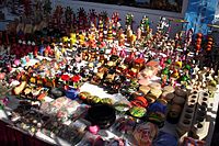 Wooden toys of Channapatna
Tourist places in and around the city
The Following are some of the tourist places in and around the city:
1) Kanva Maharshi Math and Brahmanya Theertha Brundavan is 6KM away from Channapatna on the way to Kanva Reservoir.
2) Kanva Reservoir is 13KM from Channapatna with automatic siphon system.
3) DoddaMallur Aprameya Swamy Temple which also has the world famous Ambegal Krishna whose beauty inspired the famous poet Purandharadasa to compose "Jagadodharana Aadisidale Yashoda ...." is just 2KM away from Channapatna on the Highway towards Mysore. Mallur is also known as Dakshina Ayodhya. Thayar: Sri Aravindavalli thayar.
4) Kengal Aanjaneya Swamy Temple is on the way to Channapatna from Bangalore. 5KM before Channapatna. It is situated beside the Bangalore to Mysore High-Way.
5) Igloor Barrage is 20 km away from the Channapatna City. Igloor Barrage is on the way to Santemogenahalli and Akkooru.
6) Bettada Timmappa is 13KM away from Channapatna. It's on the way to Nidasalige city.
7) Bevoor Mutt
8) Revana Siddeswara Betta
9) Kokkare Bellur bird sanctuary: Spotbilled Pelicans and Painted Storks from different countries fly here and live for few months.
10) Sri Nadhi Narasimha temple is 2 km from the DoddaMallur Aprameya Swamy Temple. This temple is on the right hand side on the Bangalore Mysore highway.
11) Mathe Manchamma thayi temple in Belakere village which is there off Bangalore-Mysore highway(1 KM towards south) 9 KM from taluk head quarter Channapatna.
12)Sri NarasimhaSwamy hill near Belakere village which is there off Bangalore-Mysore highway.
DevaraHosahalli 6 KM from center of town.
Gowdagere Sri Chamundeshwari Temple 16KM from Channapatna town.
Mangaleshwara Temple at Kudlur, 5 km from channapatna. Here panchalinga can be seen. Like Panchalinga Dharshana at Thalakad.
References
- ^ Falling Rain Genomics, Inc - Channapatna
- ^ "Census of India 2001: Data from the 2001 Census, including cities, villages and towns (Provisional)". Census Commission of India. Archived from the original on 2004-06-16. http://web.archive.org/web/20040616075334/http://www.censusindia.net/results/town.php?stad=A&state5=999. Retrieved 2008-11-01.
Janapada Loka
External links
Categories:- Cities and towns in Ramanagara district


Wikimedia Foundation. 2010.