- Wetzlar
-
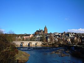
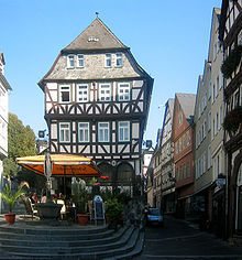
Wetzlar The old town and the old Lahnbridge 
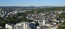
Coordinates 50°34′N 8°30′E / 50.56667°N 8.5°ECoordinates: 50°34′N 8°30′E / 50.56667°N 8.5°E Administration Country Germany State Hesse Admin. region Gießen District Lahn-Dill-Kreis Town subdivisions 8 quarters Lord Mayor Wolfram Dette (FDP) Basic statistics Area 75.67 km2 (29.22 sq mi) Elevation 148-401 m Population 51,499 (31 December 2010)[1] - Density 681 /km2 (1,763 /sq mi) Other information Time zone CET/CEST (UTC+1/+2) Licence plate LDK Postal codes 35576–35586 Area code 06441 Website wetzlar.de Wetzlar is a city in the state of Hesse, Germany. Located at 8° 30′ E, 50° 34′ N, Wetzlar straddles the river Lahn and is on the German Timber-Framework Road which passes mile upon mile of half-timbered houses. Historically, the city has acted as the hub of the Lahn-Dill-Kreis on the north edge of the Taunus. The city is known for its ancient town and its medieval cathedral.
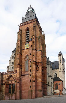
Notable architectural features include the Eisenmarkt and the steep gradients and tightly packed street layout of a medieval town. The sandstone cathedral of St. Mary was commenced in the 12th century as a Romanesque building. In the later Middle Ages the construction was continued under a master plan in Gothic style. The church was never finished, as one steeple still remains uncompleted. The cathedral suffered heavy damage in the Second World War from aerial bombing, but was restored in the 1950s. On the outskirts of town the ruins of several stone towers are to be found, situated along the river.
Contents
Geography
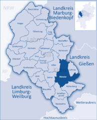
Wetzlar lies in the Lahn-Dill area in Middle Hesse on the river Lahn, not far downstream from where it changes direction from south to west in the heights near the mouth of the Dill. The town lies at a point where division the Hessian low mountain ranges divide: south of the Lahn lies the Taunus; north of the Lahn and west of the Dill the Westerwald begins; north of the Lahn and east of the Dill the Rothaargebirge begin. The highest point within town limits is the Stoppelberg at 401 m above sea level.
Wetzlar's neighbouring towns and cities are Gießen (up the Lahn from centre to centre about 12 km), Koblenz 80 km down the Lahn, Limburg an der Lahn 40 km to the west, Siegen 50 km to the northwest, Dillenburg 30 km to the north, Marburg 30 km to the northeast and Frankfurt am Main 60 km to the south.
Wetzlar and Gießen are the two cores of this small (about 200,000 inhabitants) urban agglomeration in Middle Hesse. Along the valleys of the Lahn (east and west) and Dill (north) are heavily built-up neighbouring communities, whose built-up areas in some places merge with Wetzlar's. The low mountain ranges around Wetzlar to the northwest, northeast and south, on the other hand, are heavily wooded and very thinly populated.
Neighbouring communities
Wetzlar borders in the northwest on the town of Aßlar (Lahn-Dill-Kreis), to the north and northeast on the communities of Hohenahr (Lahn-Dill-Kreis) and Biebertal (Gießen district), to the east on the communities of Lahnau (Lahn-Dill-Kreis) and Heuchelheim and the town of Gießen (both in Gießen district), to the south on the communities of Hüttenberg and Schöffengrund and to the west on the town of Solms (all in the Lahn-Dill-Kreis).
Constituent communities
The core area of Wetzlar with 30,684 inhabitants is divided into twelve boroughs (Stadtbezirke): Altstadt, Neustadt, Hauser Berg, Büblingshausen, Sturzkopf, Stoppelberger Hohl, Nauborner Straße, Silhöfer Aue/Westend, Altenberger Strasse, Dalheim, Dillfeld and Niedergirmes. Niedergirmes is with over 6,000 inhabitants the largest municipality.[2]
Furthermore, there are 8 districts (Stadtteile) outside the core area. Five of them have long since been swallowed up in Wetzlar's main built-up area. All, however, became part of Wetzlar with the dissolution of the city of Lahn in 1979, excluding Blasbach, Dutenhofen and Münchholzhausen which have long belonged to the city. These are east of the core towns of Naunheim (3882), Garbenheim (2080), Münchholzhausen (2420) and Dutenhofen (3152). Nauborn (3721) is located south of the core area and Steindorf (1704) follows on from the west central area. North of the core area are Blasbach (994) and Hermannstein (3588) (population in brackets, as of December 31, 2007).[3]
Climate
Wetzlar has a year-round temperate seasonal climate of the middle latitudes. Between the different elevations there are different small climatic conditions. The daily mean temperature in summer is about 17 to 18 °C (
Template:Convert/Dual/LoffAoffDxSoffT
- Invalid output type {4}="def", in {{Convert|17|to|18|def|...}}. ) in winter and about 1 to 2 °C (
Template:Convert/Dual/LoffAoffDxSoffT
- Invalid output type {4}="def", in {{Convert|1|to|2|def|...}}. ). The average rainfall is 600 to 700 mm (24 to 28 in), slightly below the German national average. On the high ground to the south and north of the Lahn valley there is a rainfall of 800 mm (31 in) which is exactly the national average.[4] The wettest months are June and December, with 74 and 73.3 mm, the driest month is February with 49.1 millimetres.Demography
Wetzlar had on the 31st December 2005 a municipal census for the city of 52,741 inhabitants (of which 21,946 are male and 24,313 female), 31,022 of which came from the core city (Kernstadt) and 21,719 in the 8 districts. Thus Wetzlar it the eleventh largest city in Hesse. The proportion of foreigners is 11.6% (6371 inhabitants), these are spread over 103 nations.[5] The unemployment rate in the district of the employment agency without the offices of Dillenburg and Wetzlar Biedenkopf (which includes the city of Wetzlar, and 12 surrounding municipalities) was in July 2009 6.9%, which corresponds to 5698 unemployed.[6]
Geology
Wetzlar lies on the eastern edge of the Rhenish Massif. The substrate consists of geologically young sediments of the Lahn and much older Devonian and Carboniferous rocks of the two main geological units of the Massif, the Lahnmulde and the so-called Giessen nappe. The northwestern part of the urban area lies on the Lahntal silt, sand and gravel, which have only slightly hardened. They were deposited by the river Lahn, at a point where its valley (which is still up to one kilometre wide) to the west becomes increasingly narrow and deep. The main part of the city is built on in part intensively folded, faulted and slated layers of shales, sandstone, quartzite and limestone. They were deposited in the Devonian and Carboniferous eras in a sea characterised by island chains, volcanoes and atolls that were pushed together and covered by a layer of rock that had been transported from another location during the Variscan orogeny period of mountain building.[7] The marine sedimentary rocks which resulted from this tectonic action now give the town its character as they were often used for building material.
History
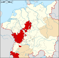
Imperial City of Wetzlar
Reichsstadt WetzlarFree Imperial City of the Holy Roman Empire ← 
12th century–1803  →
→Capital Wetzlar Government Republic Historical era Middle Ages - Settlements established 5th century BC - Gained Reichsfreiheit approx 12th century 12th century - Reichskammergericht
moved to Wetzlar
1689- Mediatised to
Archbishop of Regensburg
1803 1803- Granted to Prussia 1815 The town's founding date has up to now never been established or known. There were "Bandkeramiker" settlements right on the western town limits, partly from 5,000 years BC.
In the proximity of Wetzlar there are also a few Roman remains, which were constructed during the reign of the emperor Augustus. There was a military camp at Dorlar and some Roman roadwork. The most important finding however is an uncompleted city (Waldgirmes Forum), which has been excavated since 1993. After their defeat in the battle of the Teutoburg Forest the Romans abandoned the area and withdrew to the Rhine border.
The name "Wetzlar" had come into being most likely by the 3rd century to the 8th century. The last syllable "―lar" suggests that the town was in existence by the 3rd century. The ending may be Celtic or Frankish (in the latter case, most likely referring to wooden defences around the town). The Conradine Gebhard, Count in the Wetterau, and as of 904 Duke of Lorraine, had a Church of the Saviour consecrated in 897, which replaced earlier structures. In the early 10th century came the founding of the Marienstift (monastery).
Free Imperial City
At some unknown time, Wetzlar was granted market rights, and thereby, the right to levy market dues. Within a year, a market community came into being. The monastery's forerunners were surely part of the crystallization point at which believers, traders and craftsmen met, above all on holidays.
The Hohenstaufen Emperor Frederick I Barbarossa created a Reichsvogtei (roughly "Imperial Bailiwick"), and in 1180 put Wetzlar's citizens on the same level as Frankfurt's. Wetzlar became a Free Imperial City and kept this distinction until 1803. For the town's protection, and to secure the Wetterau as an Imperial Province, he expanded high above Wetzlar the Imperial Castle (Reichsburg), which had most likely already stood in one form or another before then. The origin of the name "Reichsburg Kalsmunt" is not quite clear. The following explanation cannot be ruled out: Kals- = Karls and munt ≈ vassal, that is, a liege of the Frankish court. Thus it would seem to be a case of a building work from Charlemagne's time ("Charlemagne" is "Karl der Große" – "Charles the Great" (740s–814) – in German). Imperial coinage was struck at Kalsmunt. The commercial road, which crossed the Lahn at Wetzlar, the town's iron production, to which the Iron Market (forum ferri) still bears witness, the wool weaving mill and tanning seemed a good basis on which to develop the town further.
In 1285 the "false emperor" Dietrich Holzschuh, called Tile Kolup, who claimed to be Frederick II, Holy Roman Emperor (who actually had already died, in Italy in 1250) came to Wetzlar. When the rightful king, Rudolph I heard of this and came to Wetzlar, the city leaders seized Tile Kolup and handed him over. He was sentenced as a warlock, a heretic and a blasphemer to a fiery death, which he suffered the next day in Wetzlar at the stake.
Until 1250, most of the town fortifications, whose remains can still be seen today, were complete. By the middle of the 14th century, it is reckoned, the town's population was 6,000, making it by the standards of the time a "city". About 1350, the high point of the town's development in the Middle Ages was reached.
Decades-long feuds with the Counts of Solms, who were trying to make Wetzlar into a Solms-domain city, threatened the vital commercial road. The Emperor supported the town, albeit vainly. The city plunged into debt and in 1387 it fell under forced administration; however, it was incorporated into the Swabian League of Towns. The town's decline led by the end of the Thirty Years' War to a drop in population, to 1,500.
A stroke of luck came Wetzlar's way in 1689 when the Holy Roman Empire's highest court, the Reichskammergericht (Imperial Chamber Court) was moved from Speyer to Wetzlar after Speyer had been devastated by the French in the war of the Palatinate succession. Besides Vienna (residence of the Emperor) and Regensburg (seat of the Imperial Diet) Wetzlar thus gained a central function within the Holy Roman Empire and although it remained a tiny town it was regarded as one of its capitals. In the summer of 1772, Johann Wolfgang von Goethe was at the Reichskammergericht as a trainee. His novel The Sorrows of Young Werther is inspired by real events which Goethe experienced in Wetzlar. In 1803 Wetzlar came under the rule of Karl Theodor Anton Maria von Dalberg, the Archchancellor of the Holy Roman Empire and a close ally of Napoleon Bonaparte and thus lost its status as a free town. With the Empire's dissolution in 1806, the great court also met its end. It was replaced by a school of law founded by Karl von Dalberg. After the Congress of Vienna, the area passed to Prussia in 1815, and in 1822 it became the seat of the newly formed district of Wetzlar, which later became an exclave of the Rhine Province.
Wetzlar becomes an industrial town
Industrialization began once the Lahn was made into a navigable waterway. With the opening of two railway lines in 1862-1863 (the Lahntalbahn from Wetzlar to Koblenz and the Cologne-Gießen Railway), which met in Wetzlar, the town found itself connected to raw material and outlet markets, becoming an industrial town.
In 1869, in the municipal area alone, 100 ore mines were in operation. Wetzlar's first blast furnace, built by the brothers Buderus, went into service in 1872. As well, world-famous optical and precision mechanics companies such as Leitz (Leica), Hensoldt (Zeiss), Pfeiffer, Philips, Loh, Seibert, Hollmann, Minox and many others set up shop in the town.
For more than one hundred years, the iron ore found in the Lahn-Dill area (haematite) was processed at the Sophienhütte ironworks. As of 1887, iron ore mines were being shut down one by one, interrupted only by the First World War, because foreign ore from strip mines was being offered at lower prices on the world market. In 1926, mining came to an end altogether.
Wetzlar in the 20th century
As part of the progressing industrialization, the town outgrew its mediaeval town limits. In 1903 came the amalgamation of Niedergirmes with its extensive industrial works and the railway station neighbourhood. By the end of the First World War, the population had risen to over 15,000. Owing to increasing transportation problems, a ringroad was built to the west of the Old Town (Altstadt), taking the load off the old stone bridge across the Lahn by building a further bridge. In the Second World War, the town, being an industrial stonghold, also became the target of heavy bombing, which destroyed much of the railway station neighbourhood and Niedergirmes. The historic Old Town, however, was mostly spared the air raids.
After the Second World War ended in 1945, Wetzlar found itself in the American occupation zone, and later, once new boundaries had been drawn, in the Federal State of Hesse. By the beginning of the 1950s, owing to the huge numbers of displaced people from lost territories and refugees flooding into the town, the population had doubled to 30,000.
On 1 January 1977, as part of Hesse's municipal reforms, Wetzlar was united with the neighbouring town of Gießen and fourteen outlying communities to form the city of Lahn. This district-free city had about 156,000 inhabitants. The amalgamation was very unpopular, and after persistent protests – not least of all from Wetzlar – the city of Lahn was dissolved on 31 July 1979, and Wetzlar once again became an independent town. The municipal reforms, however, had been "worth the trouble" for Wetzlar inasmuch as the town gained eight new outlying communities in the deal, making both the town's area and population considerably greater than they had been. Moreover, Wetzlar has since this time been the seat of the Lahn-Dill-Kreis, which also came into being at the same time.
Politics
Town council
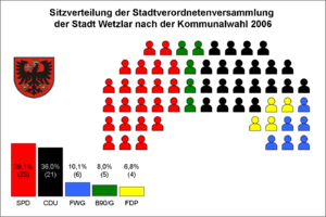
Elections to the town council were last held on 26 March 2006 for a five-year term. The SPD lost one seat, the Greens gained one. Voter participation fell from 45.9% in 2001 to 37.2%. Out of 38,918 eligible voters, 14,468 went to the polls.[8] Hesse's next municipal elections will be held in March 2011.
Parties and voter communities Share in % Seats CDU Christian Democratic Union 36.0 21 SPD Social Democratic Party of Germany 39.1 23 Greens Alliance '90/The Greens 8.0 5 FDP Free Democratic Party 6.8 4 FWG Freie Wählergemeinschaft 10.1 6 total 100 59 Note: FWG is a citizens' coalition.
The majority of seats, and thereby the power, is held by a CDU-FWG-FDP coalition which holds, as also before the elections, 31 of the 59 seats.
Oberbürgermeister
Coat of arms
Wetzlar's civic coat of arms might heraldically be described thus: In gules a spreadeagle sable armed, langued and crowned Or, over its wing dexter a cross pattée argent.
The black Imperial eagle on a red background and with a golden crown stands for the town's former Imperial immediacy as a Free Imperial City (see History). The silver cross stands for the former Imperial City's right to mint coins. The arms are almost unchanged from those borne in the 12th century.
A new version of the coat of arms was to have been introduced in 2003, but it did not catch on. In the end, the "old" arms were kept.
Transport
- Motorway
- Wetzlar lies on the A45 (Sauerland-line Dortmund – Aschaffenburg) with the junctions Wetzlarer Kreuz [Wetzlar Cross] (to A480 to Wetzlar-North, Asslar and Wetzlar-Blasbach), Wetzlar-Ost [Wetzlar-East] (to B49 in direction city centre) and Wetzlar-Süd [Wetzlar-South] (into the southern quarters Münchholzhausen and Dutenhofen). The motorway A480 should actually lead from the Luxembourg border over Trier through the Westerwald up to the Hattenbacher Dreieck ([Hattenbach Triangle] to the A7). This distance was planned as A48. Because of high costs it was never completely realized. Now the B49 are to take up the traffic. Today the part of the A48 between Gießen and Wetzlar is called A480 and leads only from the departure Wetzlar-North/Asslar up to the Wetzlarer Cross and beyond that up to the present motorway end with the improvised exit after Wetzlar-Blasbach. Some kilometres to the northeast of Gießen the part removed so far continues and leads from Heuchelheim to the Reiskirchener Dreieck [Reiskirchen Triangle] at the A5.
- Federal highway
- The following federal highways lead through the city: B49 (Trier – Wetzlar – Alsfeld) in direction east–west and B277 (Siegen-Dillenburg-Wetzlar) as north-south connection. The B277a is rather a bypass road, it connects Asslar with Wetzlar-Dalheim. Between Wetzlar and Limburg (B49) the federal route is currently being expanded from one lane to two in each direction.
- Railways
- Wetzlar lies on the railroad lines Frankfurt am Main – Siegen – Cologne and Gießen – Limburg – Koblenz, which meet at Wetzlar Station and are operated by RegionalBahn and RegionalExpress-trains. Since 2009 every morning and evening an EuroCity stops on its way to Klagenfurt or rather to Siegen. Beside the station Wetzlar, a further station exists in Dutenhofen. The earlier station in Wetzlar-Garbenheim was closed when this route to Wetzlar was shut down. The freight station has become smaller; since February 2007, Railion operates freight trains for central Hesse. Larger cities, which are directly reachable from Wetzlar are: Aachen, Cologne, Koblenz, Frankfurt am Main, Munich, Salzburg, Siegen and Stuttgart.
- Public transport
- The city has a well organised urban bus network with twelve lines, all connecting to the central bus station (ZOB), in addition various lines handle the overland traffic into the surrounding countryside of Wetzlar. In the late evening hours the night bus line 007, the so-called DiscoBus, serves nearly all parts of the city. On all lines, the RMV pricing applies. Additionally the CityBus links the Old Town for 50c, weekdays from 10:00 to 19:00 and on workdays to 15:00 with the station and the shopping centre FORUM Wetzlar every 20 minutes.
- Airtraffic
- The distance to Frankfurt Airport is about 70 km, to the regional airport Siegen approx. 40 km.
Economy and business
Retailing
According to the figures of the Society for Consumer Research is Wetzlar one of the most attractive commercial locations in Germany. The city has a high centrality coefficient and a retail turnover of around EUR 10,000 per inhabitant. In Germany it takes third place among all cities with over 50,000 inhabitants.[9]
Wetzlar has two large shopping centres, of those the FORUM Wetzlar is the largest in central Hesse (Mittelhessen). It has around 110 shops and accommodates a large multi-storey car park of 1700 places. Retail trade is located mainly in the areas Bahnhofsstraße, Karl-Kellner-Ring and the historic old town. In the Bahnhofstraße, the Karl-Kellner-Ring and in the two shopping centres where almost all goods are available.
Enterprises
The city is home to some internationally active and well known enterprises. The Buderus company was created in the year 1731 and is one of the oldest still existing (large) enterprises. As BBT Thermotechnik, now part of the Bosch group, Buderus was for many decades one of the largest employers in the central Hessian area with more than 10,000 persons employed in Wetzlar alone (worldwide over 16,000), working in the areas casting (with cement), high-grade steel and heating technologies. Economic changes, repeated shifts of the stock majority as well as close-downs and sales of various divisions have strongly changed the company in the meantime. However, it ranks among the largest enterprises in Hesse. Wetzlar is apart from Jena and Oberkochen a German centre for optics as well as the most important German location for the precision engineering industry. The manufactured products have gained worldwide reputation. One of the most important companies in the area of microscopy is Leica Microsystems (formerly known as Ernst Leitz), which in its peak times employed over 7000 people in the city. Small format (35 mm) photography was invented in Wetzlar, and Leica cameras are well known for their excellent quality. In addition there are cameras of the companies Leidolf and Minox, binoculars and telescopes made by the company Hensoldt AG (now Carl Zeiss), part of the Zeiss group (over 2,000 people employed in peak times). Other well-known firms are Philips (with about 1,200 employed at times) or Siemens AG and Siemens VDO or the Sancura BKK, a supraregional health insurance company, which is fusioned with the Taunus BKK. The Business park Spilburg, former barracks, became home to a number of innovative enterprises, particularly in the area of optics/precision mechanics, information technology and services. Additionally, areas in the Westend as well as the Hörnsheimer Eck and the Dillfeld are available for new businesses to set up.
Higher education
The Technische Hochschule Mittelhessen is one of the largest universities of applied sciences in Germany. The campus in Wetzlar is located in a redeveloped former military barracks area.
International relations
Wetzlar is twinned with:
 Siena, Italy
 Colchester, United Kingdom
 Avignon, France
 Berlin-Neukölln, Germany
 Písek, Czech Republic
 Ilmenau, Germany
 Schladming, Austria
Sponsorships to
Partnerships with
Sightseeing
Historic Old Town
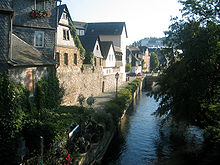
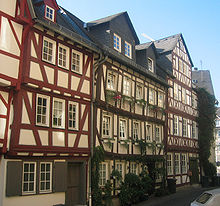
The tightly woven ensemble of historic buildings and houses in the Old Town (Altstadt) with its half-timbered houses and stone buildings from Romanesque (Wetzlar Cathedral) to Gothic to Renaissance and Baroque is to a great extent as it was in the late 18th century, preserved and extensively restored. Thus the great squares of Buttermarkt/Domplatz ("Butter Market/Cathedral Square"), Fischmarkt ("Fish Market"), Eisenmarkt ("Iron Market"), Kornmarkt ("Grain Market"), and the former Franziskanerhof ("Franciscan Yard"), now called Schillerplatz. From the roughly 50 noteworthy buildings, a few are listed here:
- A straight-walled half-timbered house from 1356
- The "Old Coin" (Alte Münze) at the Iron Market
- The "Roman Emperor" (Römische Kaiser) from the 15th century, a former theatre and ballroom
- The former Teutonic Knights' Court (Deutschordenshof), today a town museum
- The Lottehaus, Charlotte Buff's house
- The Jerusalemhaus in which Karl Wilhelm Jerusalem shot himself, thus attaining sad fame as Werther
- The princely Palais Papius in which is nowadays found the collection of historical furniture assembled by Dr Irmgard Freiin von Lemmers-Danforth
Also in the old outlying towns of Langgasse and Neustadt ("New Town"), connected to the Old Town by the Old Lahn Bridge (Alte Lahnbrücke), a number of historic buildings are preserved and are worth seeing. The New Town, however, has lost its mediaeval feel owing to its 20th-century four-lane roads.
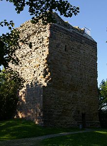
The stone Alte Lahnbrücke was first mentioned in 1288. A building meant to serve as the town hall, built in the mid 14th century, was used by the Reichskammergericht as their seat and offices from 1689 to 1806, after many remodellings. Considerable remains of the town's 13th- and 14th-century fortifications are still preserved, for instance a fortress tower known as the Schneiderturm ("Tailor's Tower") or Säuturm ("Sow's Tower"), the Kalsmuntpforte ("Kalsmunt Gate" – see History) which was the town gate for the earlier suburb of Silhofen, as well as large sections of the town wall.
Wetzlar Cathedral
The Wetzlarer Dom (Wetzlar Cathedral) is one of Wetzlar's landmark buildings. Building work began on the cathedral in 1230 and is still not finished. It is the successor to a former "Church of the Saviour" consecrated in 897. The monastery and parish church was called Cathedral as of the late 17th century. This designation was acquired during the time that the Reichskammergericht was active in Wetzlar (1693–1806), when the Elector-Archbishop of Trier was Monastery Provost, making the church a "Bishop's Church".
Culture
The Phantastische Bibliothek Wetzlar (Fantastic Library of Wetzlar) is one of the largest public libraries specialising in fantastic literature worldwide, it is the largest in Europe. It is generally a reference library, open for the public and scientists.
Arena Wetzlar is a multi-functional arena and is primarily used for pop concerts, shows and team handball and is the home arena of HSG Wetzlar (Handball Bundesliga).
Every summer, operas, music and drama are performed in the open air at the Freilichtbühne during the month-long Wetzlar Festival ("Wetzlarer Festspiele").
References
- ^ "Die Bevölkerung der hessischen Gemeinden" (in German). Hessisches Statistisches Landesamt. 31 December 2010. http://www.statistik-hessen.de/static/publikationen/A/AI2_AII_AIII_AV_10-1hj_pdf.zip.
- ^ Stadt Wetzlar: Der Stadtbezirk Niedergirmes
- ^ Stadt Wetzlar: Hauptwohnstatistik und Bevölkerungsentwicklung
- ^ Umweltatlas Hessen. In: Hessisches Landesamt für Umwelt und Geologie, 2005.
- ^ wetzlar.de Stadtporträt, Bevölkerungsstatistik, Nationalitätenstatistik
- ^ Agentur für Arbeit Wetzlar, 2009.
- ^ Walter, Roland et al.: Geologie von Mitteleuropa. 5. Auflage, Schweizerbarth’sche Verlagsbuchhandlung, Stuttgart 1992, ISBN 3-510-65149-9.
- ^ Hessisches Statistisches Landesamt – Endgültiges Ergebnis der Gemeindewahl am 26. März 2006 532023 Wetzlar, St.
- ^ Hanno Bender und Marcelo Crescenti in Der Handel 06/2008: Die besten Standorte. Accessed 4 June 2009.
External links

Siegen, Düsseldorf, Cologne Paderborn, Dortmund Kassel, Marburg 
Koblenz, Bonn 
Gießen, Fulda  Wetzlar

Wiesbaden, Mainz Frankfurt, Darmstadt, Bad Homburg Offenbach Towns and municipalities in Lahn-Dill-Kreis Aßlar | Bischoffen | Braunfels | Breitscheid | Dietzhölztal | Dillenburg | Driedorf | Ehringshausen | Eschenburg | Greifenstein | Haiger | Herborn | Hohenahr | Hüttenberg | Lahnau | Leun | Mittenaar | Schöffengrund | Siegbach | Sinn | Solms | Waldsolms | WetzlarCategories:- Towns in Hesse
- Former republics
- Former countries in Europe
- States of the Holy Roman Empire
- City-states
- Imperial free cities
- States and territories established in the 12th century
- States and territories disestablished in 1803
- Wetzlar
- Lahn-Dill-Kreis
- 1803 disestablishments
Wikimedia Foundation. 2010.

