- Obernai
-
Obernai
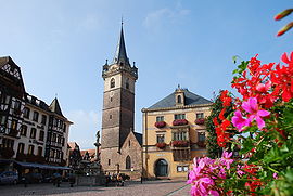
Place du marché Administration Country France Region Alsace Department Bas-Rhin Arrondissement Sélestat-Erstein Canton Obernai Mayor Bernard Fischer
(2001–2008)Statistics Elevation 156–572 m (512–1,877 ft)
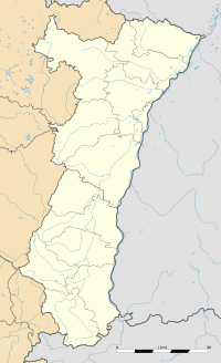
(avg. 185 m/607 ft)Land area1 25.78 km2 (9.95 sq mi) Population2 11,009 (2006) - Density 427 /km2 (1,110 /sq mi) INSEE/Postal code 67348/ 67210 1 French Land Register data, which excludes lakes, ponds, glaciers > 1 km² (0.386 sq mi or 247 acres) and river estuaries. 2 Population without double counting: residents of multiple communes (e.g., students and military personnel) only counted once. Coordinates: 48°27′47″N 7°28′58″E / 48.463055°N 7.482777°E
Imperial City of Obernai
Reichstàdt Owernah (gsw)
Reichsstadt Oberehnheim (de)Free Imperial City of the Holy Roman Empire ← 
ca 1283–1648  →
→Coat of arms
Capital Obernai Government Republic Historical era Middle Ages - Founded 778 - Gained town rights 1240 - Gained Reichsfreiheit ca 1283 - Joined Décapole 1354 - Lost Reichsfreiheit 1648 - Annexed by France 1679 Obernai (French: Obernai; Alsatian: Owernah; German: Oberehnheim) commune in the Bas-Rhin department in Alsace in north-eastern France. It lies on the eastern slopes of the Vosges mountains.
Obernai is a rapidly growing city, its number of inhabitants having gone up from 6,304 in 1968 to 11,099 in 2006.[1] The metropolitan area of Obernai had 12,369 inhabitants in 2006, from 7,293 in 1968.[2]
Contents
History
The Obernai region, which was the property of the dukes of Alsace in the 7th century, is the birthplace of St. Odile, daughter of the Duke, who would become the Patron Saint of Alsace.
The Obernai name first appears in 1240, when the village acquires the status of town under the tutelage of the Hohenstaufen family. The town then prospered. It became a member of the Décapole in 1354, an alliance of ten towns of the Holy Roman Empire in Alsace. Obernai's status reaches its apex in the 15th and 16th century. In 1562, Emperor Ferdinand I visited the prosperous town of Obernai.
The Thirty Years' War (1618–48) damaged the town, which was occupied by the Imperial troops then by the Swedes. The town was ransomed and ceded to France in 1679, and started to recover some of its prosperity, without totally recapturing its former glory.
The town was annexed by Germany in 1871 with the rest of Alsace then was returned to France after World War I in 1918.
Economy
Obernai is an important center of wine and beer production as well as a touristic destination. The industrial activity features the following companies: Hager, Kronenbourg, Triumph, Sobovia, Supra and Stoeffler. The historical wine of the city is called the Vin du Pistolet in reference to a local legend.
Sights
- domain of the Léonardsau (19th century – early 20th century): current museum of the horse and the horse carriage.
- Truttenhausen abbey (in ruin): old monastery of the regular canons of St-Augustin (15th century).
- Gail Castle (1826–27): Currently the Freppel High School
- Oberkirch Castle: rebuilt between 1843 and 1846 with the characteristics of an older fortified castle of the 16th or 17th century.
- El Biar Castle: Built between 1864 and 1865 on the site of an old flour mill, by General de Vives (1802, 1884); it is named after a residential section of Algiers.
- Old six-bucket well (1579)
- Clocktower (Kappelturm)
- Wheat Market (Halle aux Blés)
- Romanesque house in the rue des Pélerins
- Old Synagogue [3]
See also
- Klevener de Heiligenstein, a wine style produced in Obernai
- Communes of the Bas-Rhin department
References
External links
 Media related to Obernai at Wikimedia Commons
 Texts on Wikisource:
-
- Obernai (listed as Ehenheim) in the Topographia Alsatiae (Elsass)
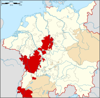
 Upper Rhenish Circle (1500–1806) of the Holy Roman Empire
Ecclesiastical 
Secular Bar · Heitersheim · Hersfeld · Hesse (Darmstadt, Homburg, Kassel, Marburg, Rheinfels) · Isenburg-Birstein · Kaiserslautern · Lorraine2 · Nassau (Idstein, Ottweiler, Saarbrücken, Usingen, Weilburg) · Salm (Kyrburg, Salm) · Savoy · Simmern · Solms-Braunfels · Sponheim3 · Veldenz / Lautereck · Waldeck3 · ZweibrückenCounts
and LordsWith
Reichstag
seatsHanau (Lichtenberg, Münzenberg)4 · Isenburg (Birstein, Büdingen, Büdingen-Birstein) · Königstein (Mainz, Stolberg) · Kriechingen · Leiningen (Dagsburg, Hardenburg, Westerburg) · Salm (Grehweiler, Grumbach) · Solms (Hohensolms, Laubach, Lich, Rödelheim) · Wetterau · Wittgenstein (Berleburg, Wittgenstein)WithoutBretzenheim · Dagstuhl · Falkenstein · Isenburg (Meerholz, Wächtersbach) · Mensfelden · Olbrück · Reipoltskirchen · Salm-Dhaun · WartenbergCities Colmar · Hagenau · Kaisersberg · Landau · Mühlhausen5 · Münster im Elsaß · Oberehnheim · Rosheim · Schlettstadt · Türkheim · WeißenburgOthers1 Part of the Three Bishoprics. 2 Nomeny after 1737. 3 without Reichstag seat. 4 until 1736. 5 Joined Swiss Confederacy in 1515.Categories:- Former republics
- Former countries in Europe
- States of the Holy Roman Empire
- City-states
- Imperial free cities
- States and territories established in the 13th century
- States and territories disestablished in 1648
- Bas-Rhin geography stubs
- Communes of Bas-Rhin
Wikimedia Foundation. 2010.


