- Lahn
Infobox River | river_name = Lahn
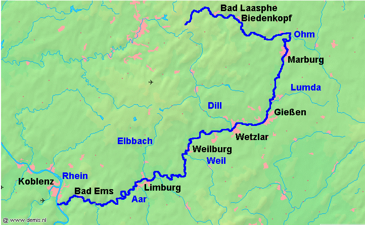
caption = Map of the Lahn river from its source in theRothaargebirge to its mouth nearKoblenz .
origin =Sauerland
mouth =Rhine
basin_countries =Germany
length = 242 km
elevation = 628 m
discharge =
watershed = 5,964 km²The Lahn is ariver inGermany , a right tributary of theRhine . It has its source at the Ederkopf mountain in theRothaargebirge , the highest part of theSauerland . After 242 km it meets theRhine atLahnstein , nearKoblenz . Important cities along the Lahn includeMarburg ,Gießen ,Wetzlar ,Limburg an der Lahn ,Weilburg andBad Ems . The tributaries to the Lahn River include the Dill, the Weil and the Aar. The river features a lot of dams with locks allowing regular shipping from its mouth up to Runkel. Riverboats are also used on small section north of the dam in Giessen.Cities and Villages along the River (from source to mouth)
* Netphen
* Bad Laasphe
* Biedenkopf
* Dautphetal
* Lahntal
* Cölbe
*Marburg
* Weimar (Lahn)
* Fronhausen* Lollar
* Wettenberg
*Gießen
* Heuchelheim (Hessen)
* Lahnau
*Wetzlar
*Solms
*Leun
*Löhnberg *
Weilburg
* Weinbach
* Runkel
*Limburg an der Lahn
* Verbandsgemeinde Diez
* Nassau
*Bad Ems
*Lahnstein References
* [http://www.britannica.com/eb/article-9046848/Lahn-River Lahn River Entry at the Encyclopedia Britannica]
* [http://www.rhein-lahn-info.de/lahnfuehrer/ Lahn River guide for canoing]
Wikimedia Foundation. 2010.