- National Register of Historic Places listings in Washington County, Oklahoma
-
 Location of Washington County in Oklahoma
This is a list of the National Register of Historic Places listings in Washington County, Oklahoma.
This is intended to be a complete list of the properties and districts on the National Register of Historic Places in Washington County, Oklahoma, United States. The locations of National Register properties and districts for which the latitude and longitude coordinates are included below, may be seen in a Google map.[1]
There are 8 properties and districts listed on the National Register in the county, including 1 National Historic Landmark. Another property was once listed but has since been removed.
-
- This National Park Service list is complete through NPS recent listings posted November 10, 2011.[2]
Current listings
[3] Landmark name [4] Image Date listed Location City or town Summary 1 Bartlesville Downtown Historic District December 27, 1991 Roughly bounded by SE. 2nd St., SE. Cherokee Ave., SE. 4th St., and the former ATSF railroad tracks
36°45′02″N 95°58′35″W / 36.750556°N 95.976389°WBartlesville 2 Dewey Hotel April 4, 1975 Delaware and Don Tyler Ave.
36°47′57″N 95°56′15″W / 36.799167°N 95.9375°WDewey 3 House at 1554 SW Rogers February 9, 2009 1554 SW. Rogers
36°44′05″N 95°59′28″W / 36.734722°N 95.991111°WBartlesville 4 LaQuinta July 15, 1982 2201 Silver Lake Rd.
36°43′03″N 95°57′30″W / 36.7175°N 95.958333°WBartlesville 5 Nellie Johnstone No. 1 April 11, 1972 Johnstone Park
36°45′23″N 95°58′19″W / 36.756389°N 95.971944°WBartlesville 6 Old Washington County Courthouse January 26, 1981 400 Frank Phillips Boulevard
36°45′01″N 95°58′17″W / 36.750278°N 95.971389°WBartlesville 7 Frank and Jane Phillips House March 13, 1975 1107 SE. Cherokee Ave.
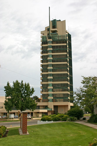
36°44′31″N 95°58′30″W / 36.741944°N 95.975°WBartlesville 8 Price Tower 
September 13, 1974 510 Dewey Ave.
36°44′51″N 95°58′34″W / 36.7475°N 95.976111°WBartlesville Former listing
[3] Landmark name Image Date listed Location City or town Summary 1 Civic Center Listed December 29, 1989, delisted June 3, 2009 Johnstone Ave. between 6th St. and Adams Boulevard
36°44′49″N 95°58′39″W / 36.74694°N 95.9775°WBartlesville Demolished[5] See also
- List of National Historic Landmarks in Oklahoma
- National Register of Historic Places listings in Oklahoma
References
- ^ The latitude and longitude information provided in this table was derived originally from the National Register Information System, which has been found to be fairly accurate for about 99% of listings. For about 1% of NRIS original coordinates, experience has shown that one or both coordinates are typos or otherwise extremely far off; some corrections may have been made. A more subtle problem causes many locations to be off by up to 150 yards, depending on location in the country: most NRIS coordinates were derived from tracing out latitude and longitudes off of USGS topographical quadrant maps created under North American Datum of 1927, which differs from the current, highly accurate GPS system used by Google maps. Chicago is about right, but NRIS longitudes in Washington are higher by about 4.5 seconds, and are lower by about 2.0 seconds in Maine. Latitudes differ by about 1.0 second in Florida. Some locations in this table may have been corrected to current GPS standards.
- ^ "National Register of Historic Places: Weekly List Actions". National Park Service, United States Department of the Interior. Retrieved on November 10, 2011.
- ^ a b Numbers represent an ordering by significant words. Various colorings, defined here, differentiate National Historic Landmark sites and National Register of Historic Places Districts from other NRHP buildings, structures, sites or objects.
- ^ "National Register Information System". National Register of Historic Places. National Park Service. . http://nrhp.focus.nps.gov/natreg/docs/All_Data.html.
- ^ Encyclopedia of Oklahoma History and Culture
U.S. National Register of Historic Places Topics Lists by states Alabama • Alaska • Arizona • Arkansas • California • Colorado • Connecticut • Delaware • Florida • Georgia • Hawaii • Idaho • Illinois • Indiana • Iowa • Kansas • Kentucky • Louisiana • Maine • Maryland • Massachusetts • Michigan • Minnesota • Mississippi • Missouri • Montana • Nebraska • Nevada • New Hampshire • New Jersey • New Mexico • New York • North Carolina • North Dakota • Ohio • Oklahoma • Oregon • Pennsylvania • Rhode Island • South Carolina • South Dakota • Tennessee • Texas • Utah • Vermont • Virginia • Washington • West Virginia • Wisconsin • WyomingLists by territories Lists by associated states Other  Category:National Register of Historic Places •
  Portal:National Register of Historic Places
Municipalities and communities of Washington County, Oklahoma County seat: Bartlesville Cities 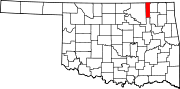
Towns Unincorporated
communitiesHog Shooter | Oak Park | Oglesby | Tuxedo
Footnotes ‡This populated place also has portions in an adjacent county or counties
Categories:- Washington County, Oklahoma
- National Register of Historic Places in Oklahoma by county
- Buildings and structures in Washington County, Oklahoma
-

Wikimedia Foundation. 2010.