- National Register of Historic Places listings in Carter County, Oklahoma
-
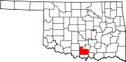
 Location of Carter County in Oklahoma
This is a list of the National Register of Historic Places listings in Carter County, Oklahoma.
This is intended to be a complete list of the properties and districts on the National Register of Historic Places in Carter County, Oklahoma, United States. The locations of National Register properties and districts for which the latitude and longitude coordinates are included below, may be seen in a Google map.[1]
There are 21 properties and districts listed on the National Register in the county.
-
- This National Park Service list is complete through NPS recent listings posted November 10, 2011.[2]
Current listings
[3] Landmark name [4] Image Date listed Location City or town Summary 1 Ardmore Carnegie Library June 2, 2000 511 Stanley, SW.
34°10′14″N 97°08′07″W / 34.170556°N 97.135278°WArdmore 2 Ardmore Historic Commercial District 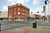
March 14, 1983 Main St. from the former Santa Fe railroad tracks to B St., N. Washington from Main to 2nd Ave., NE., and Caddo from Main to the northern side of 2nd Ave., NE.
34°10′16″N 97°07′41″W / 34.171111°N 97.128056°WArdmore 3 Ardmore Municipal Auditorium March 8, 2006 220 West Broadway
34°10′27″N 97°07′50″W / 34.174167°N 97.130556°WArdmore 4 Bethel Missionary Baptist Church January 12, 1995 Southeastern corner of the junction of Webster and Lane Sts.
34°28′56″N 97°27′41″W / 34.482222°N 97.461389°WTatums 5 Black Theater of Ardmore June 22, 1984 536 E. Main St.
34°10′13″N 97°07′22″W / 34.170278°N 97.122778°WArdmore 6 Brady Cabin December 5, 1977 38 miles northwest of Ardmore
34°25′21″N 97°25′45″W / 34.4225°N 97.429167°WArdmore 7 Carter County Courthouse 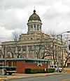
March 22, 1985 1st and B Sts., SW.
34°10′19″N 97°07′47″W / 34.171944°N 97.129722°WArdmore 8 Central Park Bandstand 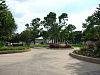
December 6, 2006 Southwest of the junction of W. Main and E St., SW. in about the middle of Central Park
34°10′25″N 97°08′03″W / 34.173611°N 97.134167°WArdmore 9 Choctaw, Oklahoma and Gulf Railroad Viaduct December 11, 2007 Junction of G St., NE. and the abandoned roadbed of the St. Louis – San Francisco Railway
34°10′44″N 97°07′06″W / 34.178889°N 97.118333°WArdmore 10 Dornick Hills Country Club September 2, 2003 519 N. Country Club Rd.
34°13′12″N 97°08′15″W / 34.22°N 97.1375°WArdmore 11 Douglass High School Auditorium July 11, 1984 800 M St., NE.
34°10′49″N 97°07′21″W / 34.180278°N 97.1225°WArdmore 12 Dunbar School June 22, 1984 13 6th St., SE.
34°10′10″N 97°07′14″W / 34.169444°N 97.120556°WArdmore 13 Galt-Franklin Home May 22, 1986 400 Country Club Rd.
34°12′56″N 97°08′08″W / 34.215556°N 97.135556°WArdmore 14 Hardy Murphy Coliseum March 8, 2006 600 Lake Murray Dr., S.
34°09′42″N 97°07′11″W / 34.161667°N 97.119722°WArdmore 15 Healdton Armory April 7, 1994 Junction of 4th and Franklin Sts.
34°14′01″N 97°29′13″W / 34.233611°N 97.486944°WHealdton 16 Healdton Oil Field Bunk House September 26, 1985 North of Wilson
34°13′02″N 97°24′34″W / 34.217222°N 97.409444°WWilson 17 Johnson Home May 22, 1986 400 Country Club Rd.
34°12′54″N 97°08′04″W / 34.215°N 97.134444°WArdmore 18 Lake Murray State Park 
October 12, 2001 1.9 miles southeast of the junction of U.S. Routes 70 and 77
34°04′56″N 97°04′13″W / 34.082222°N 97.070278°WArdmore 19 Oklahoma, New Mexico and Pacific Railroad Depot July 22, 1982 N. Washington and NE. 3rd
34°10′35″N 97°07′36″W / 34.176389°N 97.126667°WArdmore 20 Sayre-Mann House May 11, 1982 323 F St., SW.
34°10′07″N 97°08′09″W / 34.168611°N 97.135833°WArdmore 21 Zaneis School Teacher's Dormitory August 15, 1985 Off U.S. Route 70
34°10′20″N 97°29′58″W / 34.172222°N 97.499444°WHealdton See also
- List of National Historic Landmarks in Oklahoma
- National Register of Historic Places listings in Oklahoma
References
- ^ The latitude and longitude information provided in this table was derived originally from the National Register Information System, which has been found to be fairly accurate for about 99% of listings. For about 1% of NRIS original coordinates, experience has shown that one or both coordinates are typos or otherwise extremely far off; some corrections may have been made. A more subtle problem causes many locations to be off by up to 150 yards, depending on location in the country: most NRIS coordinates were derived from tracing out latitude and longitudes off of USGS topographical quadrant maps created under the North American Datum of 1927, which differs from the current, highly accurate WGS84 GPS system used by Google maps. Chicago is about right, but NRIS longitudes in Washington are higher by about 4.5 seconds, and are lower by about 2.0 seconds in Maine. Latitudes differ by about 1.0 second in Florida. Some locations in this table may have been corrected to current GPS standards.
- ^ "National Register of Historic Places: Weekly List Actions". National Park Service, United States Department of the Interior. Retrieved on November 10, 2011.
- ^ Numbers represent an ordering by significant words. Various colorings, defined here, differentiate National Historic Landmark sites and National Register of Historic Places Districts from other NRHP buildings, structures, sites or objects.
- ^ "National Register Information System". National Register of Historic Places. National Park Service. . http://nrhp.focus.nps.gov/natreg/docs/All_Data.html.
U.S. National Register of Historic Places Topics Lists by states Alabama • Alaska • Arizona • Arkansas • California • Colorado • Connecticut • Delaware • Florida • Georgia • Hawaii • Idaho • Illinois • Indiana • Iowa • Kansas • Kentucky • Louisiana • Maine • Maryland • Massachusetts • Michigan • Minnesota • Mississippi • Missouri • Montana • Nebraska • Nevada • New Hampshire • New Jersey • New Mexico • New York • North Carolina • North Dakota • Ohio • Oklahoma • Oregon • Pennsylvania • Rhode Island • South Carolina • South Dakota • Tennessee • Texas • Utah • Vermont • Virginia • Washington • West Virginia • Wisconsin • WyomingLists by territories Lists by associated states Other Municipalities and communities of Carter County, Oklahoma Cities Ardmore | Healdton | Lone Grove | Wilson
Towns Dickson | Gene Autry | Ratliff City | Springer | Tatums
Unincorporated
communitiesAlpers | Baum | Cheek | Berwyn | Brock | Caldwell Hill | Clemscot | Cobalt Junction | Countyline‡ | Dillard | Dripping Springs | Dundee | Durwood | Fox | Glenn | Graham | Hewitt | Milo | Newport | Oil City | Old Scott | Pooleville | Post Oak | Provence | Pruitt City | Reck | Rexroat | Tussy‡ | Wirt | Woodford | Zaneis
Ghost towns Pike City
Footnotes ‡This populated place also has portions in an adjacent county or counties
Categories:- Carter County, Oklahoma
- National Register of Historic Places in Oklahoma by county
- Buildings and structures in Carter County, Oklahoma
-


Wikimedia Foundation. 2010.