- Dickson, Oklahoma
-
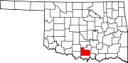
Dickson — Town — Location within the state of Oklahoma
 Dickson
Coordinates: 34°11′32″N 96°59′28″W / 34.19222°N 96.99111°WCoordinates: 34°11′32″N 96°59′28″W / 34.19222°N 96.99111°W Country United States State Oklahoma County Carter Area – Total 14.2 sq mi (36.8 km2) – Land 14.2 sq mi (36.8 km2) Population (2000) – Total 1,139 – Density 80.2/sq mi (31/km2) Time zone Central (CST) (UTC-6) – Summer (DST) CST (UTC-5) ZIP codes 73401 Area code(s) 580 FIPS code GNIS feature ID Dickson is a town in Carter County, Oklahoma, United States. The population was 1,139 at the 2000 census. It is part of the Ardmore, Oklahoma Micropolitan Statistical Area.
Contents
Life
Dickson, Oklahoma, has no post office, so the residents of the town have an Ardmore, OK address. The town is home to many employees who work in Ardmore's manufacturing plants and light industrial businesses. There are a few businesses at the cross roads of State Highway 177 and State Highway 199 including a bank, gas station, day care, church, and bull dozer service. Most of the community travel into Ardmore (which is about 10 miles west) to either work or shop. Dickson is said to have grown rapidly in recent years, the new estimated population is at 2,200 which is double from 1,100 in the 2000 census.
School
Dickson public schools are in the town of Dickson, the school consists of grades K-12. Dickson High School is known for their outstanding agriculture program. The school is also known for the girls basketball and softball teams. In the mid 1990s the Dickson Comet Cross Country team won the state tournament for 3 years in a row under the coaching of Ron Love. The most recent state championship came when the powerlifting team took the Oklahoma Large-School team championship in 2008.
Geography
Dickson is located at 34°11′32″N 96°59′28″W / 34.19222°N 96.99111°W (34.192140, -96.991160)[1].
According to the United States Census Bureau, the town has a total area of 14.2 square miles (37 km2), of which, 14.2 square miles (37 km2) of it is land and 0.04 square miles (0.10 km2) of it (0.21%) is water.
Demographics
As of the census[2] of 2000, there were 1,139 people, 417 households, and 334 families residing in the town. The population density was 80.4 people per square mile (31.1/km²). There were 462 housing units at an average density of 32.6 per square mile (12.6/km²). The racial makeup of the town was 85.34% White, 0.44% African American, 10.18% Native American, 0.18% from other races, and 3.86% from two or more races. Hispanic or Latino of any race were 1.84% of the population.
There were 417 households out of which 35.0% had children under the age of 18 living with them, 66.7% were married couples living together, 9.8% had a female householder with no husband present, and 19.9% were non-families. 18.9% of all households were made up of individuals and 7.2% had someone living alone who was 65 years of age or older. The average household size was 2.73 and the average family size was 3.10.
In the town the population was spread out with 27.7% under the age of 18, 7.6% from 18 to 24, 27.8% from 25 to 44, 25.4% from 45 to 64, and 11.5% who were 65 years of age or older. The median age was 37 years. For every 100 females there were 98.1 males. For every 100 females age 18 and over, there were 97.4 males.
The median income for a household in the town was $33,409, and the median income for a family was $39,375. Males had a median income of $28,571 versus $21,188 for females. The per capita income for the town was $14,821. About 6.2% of families and 8.6% of the population were below the poverty line, including 7.1% of those under age 18 and 10.2% of those age 65 or over.
Education
Dickson has one high school, Dickson High School, which has been named a Blue Ribbon School of Excellence by the U.S. Department of Education.
References
- ^ "US Gazetteer files: 2010, 2000, and 1990". United States Census Bureau. 2011-02-12. http://www.census.gov/geo/www/gazetteer/gazette.html. Retrieved 2011-04-23.
- ^ "American FactFinder". United States Census Bureau. http://factfinder.census.gov. Retrieved 2008-01-31.
External links
Municipalities and communities of Carter County, Oklahoma Cities Ardmore | Healdton | Lone Grove | Wilson
Towns Dickson | Gene Autry | Ratliff City | Springer | Tatums
Unincorporated
communitiesAlpers | Baum | Cheek | Berwyn | Brock | Caldwell Hill | Clemscot | Cobalt Junction | Countyline‡ | Dillard | Dripping Springs | Dundee | Durwood | Fox | Glenn | Graham | Hewitt | Milo | Newport | Oil City | Old Scott | Pooleville | Post Oak | Provence | Pruitt City | Reck | Rexroat | Tussy‡ | Wirt | Woodford | Zaneis
Ghost towns Pike City
Footnotes ‡This populated place also has portions in an adjacent county or counties
Categories:- Populated places in Carter County, Oklahoma
- Towns in Oklahoma
- Ardmore micropolitan area


Wikimedia Foundation. 2010.