- National Register of Historic Places listings in Hamlin County, South Dakota
-
 Location of Hamlin County in South Dakota
This is a list of the National Register of Historic Places listings in Hamlin County, South Dakota.
This is intended to be a complete list of the properties on the National Register of Historic Places in Hamlin County, South Dakota, United States. The locations of National Register properties for which the latitude and longitude coordinates are included below, may be seen in a Google map.[1]
There are 13 properties listed on the National Register in the county.
-
- This National Park Service list is complete through NPS recent listings posted November 10, 2011.[2]
Current listings
[3] Landmark name [4] Image Date listed Location City or town Summary 1 Estelline Bandstand and Gazebo Park November 30, 1999 105 N. Main
44°34′22″N 96°54′09″W / 44.572778°N 96.9025°WEstelline 2 First National Bank of Norden October 26, 2005 503 Main Ave.
44°34′56″N 97°12′37″W / 44.582222°N 97.210278°WLake Norden 3 First State Bank of Hazel February 21, 1997 Main St. west of its junction with Highway 22
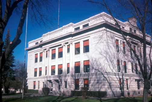
44°45′33″N 97°22′55″W / 44.759167°N 97.381944°WHazel 4 Hamlin County Courthouse 
October 12, 2000 300 4th St.
44°39′26″N 97°12′11″W / 44.657222°N 97.203056°WHayti 5 M. O. Hanson Building July 28, 2011 126 E. Main St.
44°43′19″N 97°02′09″W / 44.721944°N 97.035833°WCastlewood 6 Hendrick and Waldur Hendrickson Farm November 13, 1985 Highway 28
44°35′06″N 97°15′26″W / 44.585°N 97.257222°WLake Norden 7 Hoffelt Drug Store February 19, 2008 212 Main St.
44°34′35″N 96°54′08″W / 44.576389°N 96.902222°WEstelline 8 Kant Hotel October 31, 1985 North of Highway 28
44°35′26″N 97°28′04″W / 44.590556°N 97.467778°WBryant 9 Charles and Mary Lohr House July 19, 1982 1705 State Ave.
44°34′23″N 96°53′37″W / 44.573056°N 96.893611°WEstelline 10 Old St. Mary's Catholic Parish House December 27, 1988 5th Ave. and Underwood St.
44°35′19″N 97°27′57″W / 44.588611°N 97.465833°WBryant 11 South Dakota Dept. of Transportation Bridge No. 29-221-060 December 9, 1993 Local road over the Big Sioux River
44°42′59″N 97°02′41″W / 44.716389°N 97.044722°WCastlewood 12 South Dakota Dept. of Transportation Bridge No. 29-279-010 December 9, 1993 Local road over Stray Horse Creek
44°47′24″N 96°55′35″W / 44.79°N 96.926389°WCastlewood 13 Jacob and Amelia Tuohino Farm November 13, 1985 South of Highway 28
44°34′29″N 97°18′39″W / 44.574722°N 97.310833°WLake Norden See also
- List of National Historic Landmarks in South Dakota
- National Register of Historic Places listings in South Dakota
References
- ^ The latitude and longitude information provided in this table was derived originally from the National Register Information System, which has been found to be fairly accurate for about 99% of listings. For about 1% of NRIS original coordinates, experience has shown that one or both coordinates are typos or otherwise extremely far off; some corrections may have been made. A more subtle problem causes many locations to be off by up to 150 yards, depending on location in the country: most NRIS coordinates were derived from tracing out latitude and longitudes off of USGS topographical quadrant maps created under the North American Datum of 1927, which differs from the current, highly accurate WGS84 GPS system used by Google maps. Chicago is about right, but NRIS longitudes in Washington are higher by about 4.5 seconds, and are lower by about 2.0 seconds in Maine. Latitudes differ by about 1.0 second in Florida. Some locations in this table may have been corrected to current GPS standards.
- ^ "National Register of Historic Places: Weekly List Actions". National Park Service, United States Department of the Interior. Retrieved on November 10, 2011.
- ^ Numbers represent an ordering by significant words. Various colorings, defined here, differentiate National Historic Landmark sites and National Register of Historic Places Districts from other NRHP buildings, structures, sites or objects.
- ^ "National Register Information System". National Register of Historic Places. National Park Service. . http://nrhp.focus.nps.gov/natreg/docs/All_Data.html.
U.S. National Register of Historic Places Topics Lists by states Alabama • Alaska • Arizona • Arkansas • California • Colorado • Connecticut • Delaware • Florida • Georgia • Hawaii • Idaho • Illinois • Indiana • Iowa • Kansas • Kentucky • Louisiana • Maine • Maryland • Massachusetts • Michigan • Minnesota • Mississippi • Missouri • Montana • Nebraska • Nevada • New Hampshire • New Jersey • New Mexico • New York • North Carolina • North Dakota • Ohio • Oklahoma • Oregon • Pennsylvania • Rhode Island • South Carolina • South Dakota • Tennessee • Texas • Utah • Vermont • Virginia • Washington • West Virginia • Wisconsin • WyomingLists by territories Lists by associated states Other Municipalities and communities of Hamlin County, South Dakota Cities Bryant | Castlewood | Estelline | Lake Norden

Towns Categories:- Hamlin County, South Dakota
- National Register of Historic Places in South Dakota by county
- Buildings and structures in Hamlin County, South Dakota
-

Wikimedia Foundation. 2010.