- Mayurpur Airport
-
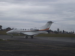
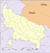
Mayurpur Airport IATA: none – ICAO: VI1D Location of airport in Uttar Pradesh</center Summary Airport type Private Operator Private / Airports Authority of India, Aditya Birla Group, Hindalco Serves Robertsganj, Singrauli Location Mayurpur, Sonbhadra, Uttar Pradesh, India Elevation AMSL 1,139 ft / 347 m Coordinates 24°07′33″N 083°02′36″E / 24.12583°N 83.04333°E Runways Direction Length Surface ft m 4,600 1,402 Asphalt Mayurpur Airport is situated at Mayurpur in Sonbhadra district in the Indian state of Uttar Pradesh. It serves many power plants of NTPC, UPRVUNL and others situated on the banks of Govind Ballabh Pant Sagar. It also serves nearby towns, NCL (coal fields), many industries and Robertsganj the district headquarter of Sonbhadra district. The airport serves the region which has many electrical power stations and known as Energy Capital of India.
- Rihandnagar NTPC
- Shaktinagar NTPC
- Vindhyanagar NTPC
- Anpara UPRVUNL
- Obra UPRVUNL
- Renusagar UPRVUNL
- Pipri UPRVUNL
- Singrauli
- Renusagar Hindalco etc.
Mirzapur division topics General Districts Rivers, dams, lakes Languages, people Transport Mining activities Singrauli CoalfieldIndustries Singrauli Super Thermal Power Station • Rihand Thermal Power Station • Anpara Thermal Power Station • Orba Thermal Power Station • Hindalco IndustriesLok Sabha constituencies Mirzapur • Bhadohi • RobertsganjSee also Cities and towns in Mirzapur district • Cities and towns in Sant Ravidas Nagar district • Cities and towns in Sonbhadra district • Villages in Mirzapur district • Villages in Sant Ravidas Nagar district • People from Mirzapur • People from Sant Ravidas NagarOther Divisions Agra • Aligarh • Allahabad • Azamgarh • Bareilly • Basti • Chitrakoot • Devipatan • Faizabad • Gorakhpur • Jhansi • Kanpur • Lucknow • Meerut • Moradabad • Saharanpur • VaranasiCategories:- Airports in Uttar Pradesh
- Indian airport stubs
Wikimedia Foundation. 2010.


