- Chorley
-
This article is about the town in Lancashire, England. For the larger local government district, see Chorley (borough). For other uses, see Chorley (disambiguation).
Coordinates: 53°39′11″N 2°37′55″W / 53.653°N 2.632°W
Chorley 
Entering Chorley town centre
 Chorley
Chorley shown within LancashirePopulation 31,556 (in 2001)[1] OS grid reference SD5817 District Chorley Shire county Lancashire Region North West Country England Sovereign state United Kingdom Post town CHORLEY Postcode district PR6, PR7 Dialling code 01257 Police Lancashire Fire Lancashire Ambulance North West EU Parliament North West England UK Parliament Chorley List of places: UK • England • Lancashire Chorley is a market town in Lancashire, in North West England. It is the largest settlement in the Borough of Chorley. The town's wealth came principally from the cotton industry. As recently as the 1970s the skyline was dominated by numerous factory chimneys, but most are now demolished: remnants of the industrial past include Morrison's chimney and a few other mill buildings, and the streets of terraced houses for mill workers. Chorley is known as the home of the Chorley cake.
Contents
History
Toponymy
The name Chorley came from Anglo-Saxon Ceorla-lēah = "the peasants' clearing". or chor leah meaning clearing on the river chor
Early and Roman history
The area around Chorley has been inhabited since at least the Bronze Age. The earliest find came from 3500 BC on Anglezarke Moor at Round Loaf. A farmer at Astley Hall Farm found a pottery burial urn from this period in 1963. This find was followed up with further excavations, with further artifacts being found. Objects from these excavations are on display at the hall's museum.[citation needed]
During the Roman era a Roman road ran near Chorley towards Wigan. It is believed that Romans settled at Brindle to the north of the town, as Roman remains were discovered there in the late 1950s.
Late Middle Ages
A market charter was granted to the town in the 1250[citation needed] and there is evidence from 1498 that the market was actually taking place[citation needed] Nowadays, the town has two markets, the Flat Iron Market and the Covered Market. For one weekend each year, French market traders sell their produce in the town, with Chorley's merchants returning the favour in France. The market has a number of specialist cheesemongers who purvey the local Lancashire cheese in various forms. Chorley is also famous for its famous Chorley cake.
During 1442 a local noble named Sir Rowland Standish (a relative of Myles Standish, Mayflower passenger and military commander of Plymouth Colony), who had fought at Agincourt, brought back to Chorley the skull and bones of Saint Lawrence and interred them at an altar at the parish church. With the bones interned there the church was renamed St. Lawrence's. Records of this are mentioned in the Harleian Manuscripts. The bones were not of the 3rd century saint but are believed to be the bones of Lorcán Ua Tuathail, a saint canonised as St. Laurence from Dublin, who died in Normandy in the 12th century. The bones went missing in the Reformation under the rule of King Henry VIII.
17th and 18th centuries
According to the apocryphal story, James I after a good meal, officially knighted Sirloin steak ("Sir" loin) at Hoghton Tower, a large stately home to north east of the town, where William Shakespeare once worked. Astley Hall is a more central stately home, set in the middle of the town's largest park, Astley Park. Oliver Cromwell visited here on his trek through the region.
On 27 November 1745 when Bonnie Prince Charlie and his Jacobites passed through Preston and Wigan on their way south to Manchester and Derby in the hope of taking London and the Crown, Chorley was a mustering point for the Government scouts tracking them. The Prince and his Army marched through Chorley itself on 10 December on the way back to Carlisle and Scotland and their dreadful day of destiny on Culloden Moor near Inverness the following 16 April. There was considerable local support in the town for that famous lost cause.
19th, 20th to 21st centuries
 Chorley Town Hall
 Chorley Council Building, Union Street
Chorley, like most Lancashire towns, gained its wealth from the industrial revolution of the 19th century which was also responsible for the town's growth. Chorley was a vital cotton town with many mills littering the skyline. Today only three mills still remain working.
Also Chorley in its location on the edge of Lancashire Coalfield was vital in coal mining. Several pits existed in Duxbury Woods, the Gillibrand area and more numerously in Coppull. Chisnall Hall Colliery at Coppull was considered the biggest Lancashire pit outside of Wigan and one of many located in the Chorley suburb. The last pit in the area to close was the Ellerbeck Colliery in 1987 which was located south of Chorley, between Coppull and Adlington.
The town played an important role during the Second World War, when it was home to the Royal Ordnance Factory, a large munitions manufacturer in the village of Euxton about 2 miles (3.2 km) from the town centre. A smaller factory was also built near the Blackburn-Wigan railway line in Heapey.
In the 1970s Chorley was designated as part of Central Lancashire new town, together with Preston and Leyland. The original aim of this project was to combine the three settlements into a single city with a population of around half a million. Although this never came to pass, and the project has since been abandoned, Chorley benefited from the urban renewal commonly associated with new towns. Examples include a bypass of the town centre, and the Market Walk shopping centre.
Chorley saw the completion of the largest Mormon temple in Europe in 1998, known as the Preston England Temple.
Governance
In 1837, Chorley joined with other townships (or civil parishes) in the area to become head of the Chorley Poor Law Union which took responsibility for the administration and funding of the Poor Law in the area.[2] Chorley became incorporated as a municipal borough in 1881 by its first mayor William Augustus Smethurst. The town's population remained roughly static in the 20th century, with the 1911 census showing 30,315 people and the 1971 census showing 31,665. Under the Local Government Act 1972, Chorley became the core of a larger non-metropolitan district on 1 April 1974. The present Borough of Chorley has forty-seven councillors, representing twenty electoral wards.
Geography
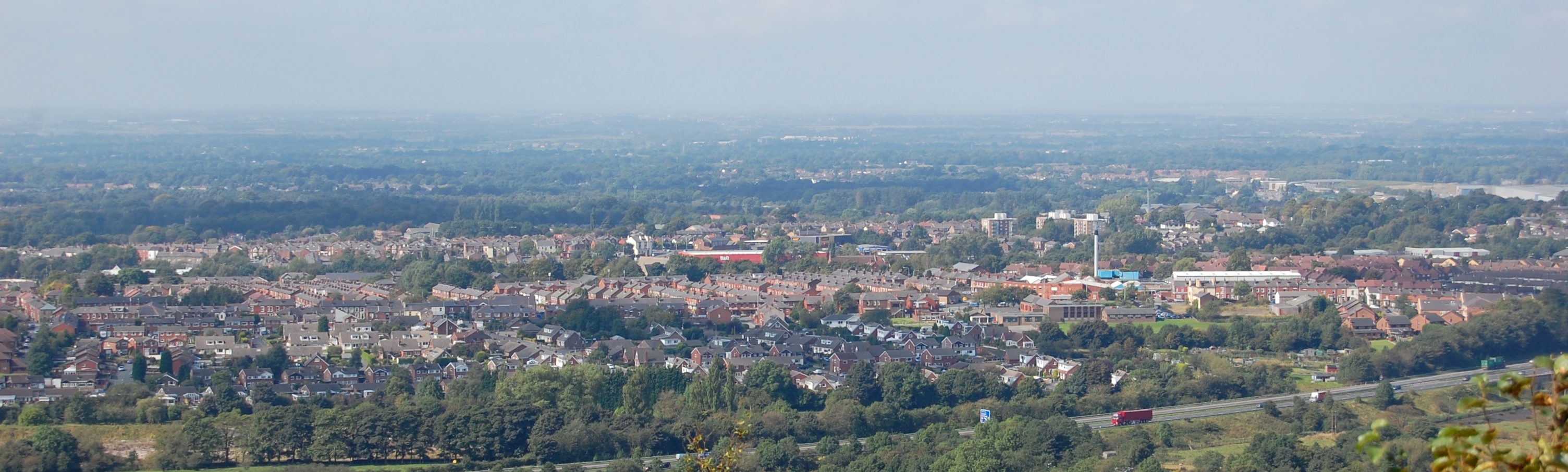
 A panoramic view over Chorley from Heapey Nab
The principal river in the town is the River Yarrow. The Black Brook is a tributary of the Yarrow. The name of the River Chor was back-formed from "Chorley" and runs not far from the centre of the town, notably through Astley Park.
Chorley is located at the foot of the West Pennine Moors and is overlooked by Healey Nab, a small hill which is part of the West Pennine Moors. It is the seat for the Borough of Chorley which is made up of Chorley and its surrounding villages. Chorley had a population of 33,424 as of the 2001 census, with the wider borough of Chorley having a population of 101,991. Chorley forms a conurbation with Preston and Leyland and was once proposed as being designated part of the Central Lancashire New Town under the New Towns Act,[3] a proposal which was eventually scaled back.[4]
Economy
 Chorley Market
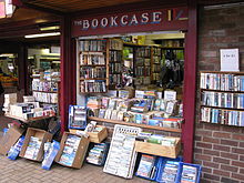 The Bookcase Shop, Chorley Market
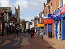 Shoppers on Chapel Street, Chorley Town Centre
The first signs of industry as with many towns in Lancashire was mining, evidence of which can be seen by the various abandoned quarries on the outskirts of the town. One of the most beautiful of these is Anglezarke Quarry, found between Chorley and Horwich. A lot of remnants can be found of mining including the old railway bridge belonging to the Duxbury Mine on Wigan Lane, eventually the mining industry was surpassed by cotton mills which litter the town scape with Chimneys (one of the few remaining examples in the one that stands at the town's Morrisons).
Another industry in Chorley has been the manufacture of trucks which it inherited from Chorley's neighbouring town of Leyland. The large factory on Pilling Lane was used heavily for the production of trucks and during the Second World War' military trucks and tanks. The factory eventually went on to spares manufacture up until the collapse of Leyland DAF in the 1990s. The works emerged as a central parts depot for the Multipart firm which eventually would come part of the RAC. The plant was closed in 2006 and work was moved to a new smaller site on Buckshaw Village. The Pilling Lane site has now been demolished to make way for new homes.
Another major industry was the manufacture of ammunition and armaments. During the 1930s one of Britain's biggest such factories to build these products was built at Euxton. The site known as ROF Chorley was vital in the Second World War and during that time over 40,000 people worked at the site. It is also the site where the bouncing bomb was built. The Nazis tried to bomb the site but could not find it as the roofs at the time were painted green, matching the surrounding grass-lands and making it very hard to spot from a plane. After World War II, production was reduced, and the final part of the site was closed in 2008 by BAE Systems.[5] A large part of the site has been redeveloped for residential and industrial use as Buckshaw Village.
Today many of the town's residents work in Manchester, Preston and nearby towns Bolton, Blackburn and Wigan.[citation needed] Leyland Trucks and BAE Systems are the Central Lancashire area's largest employers at their sites in Leyland and Samlesbury respectively.
Companies with a presence in the borough are:
- BAE Systems
- The Chorley Group
- Telent
- FedEx, North West depot located in the town
- CSC, two locations, one in Euxton and the other in Clayton-le-Woods, north of Chorley
- Multipart Solutions Limited, successor to the parts arm of the Leyland DAF
- Porter Lancastrian is a distinguished manufacturer of beer pumps, under the Porta brand.
Chorley town centre is the main location of shopping facilities in the town. Shops such as W.H. Smith, Argos, Massa's Ice Cream Parlour, Rebel Cause and The Blue House to name a few have a presence in the town. The town centre in recent years has seen the new Market Walk development and the building a new town centre Booths supermarket.
The town is also famous for its market heritage and is quoted as "Lancashire's market town". The outdoor market which has run for over 200 years, takes place every Tuesday on the Flat Iron. There is also a covered market place in the Market Square.
As well as these, Chorley has seen development out of town including retail parks which have seen the addition of Currys and B&Q to name a few. Chorley is also home to three of the four big supermarkets, including Asda, Morrisons and Tesco. Further to this Chorley was the starting point for The Chorley Group with their flagship dealership Chorley Nissan. The motor group now boasts eight dealerships across the North West with the newest addition appearing in the form of Chorley Fiat in Blackpool. The Chorley group are continuing to promote the Chorley name across the Country and beyond.
A £20m development, Market Walk Phase Two, is planned to add four shop units and a multi-storey car park to the existing Market Walk shopping centre. As of January 2008[update] this is on hold until the council finds another developer.[6]
Healthcare
Chorley is served by the local NHS hospital Chorley and South Ribble District General Hospital which is located on Euxton Lane in addition to a private hospital located in Euxton. The town also had another major hospital formerly on Eaves Lane before this closed in the 1990s. There was also the Heath Charnock isolation hospital on Hut Lane which dealt with infectious diseases before reverting to use for long term patients before closing in the 1990s.
Infrastructure
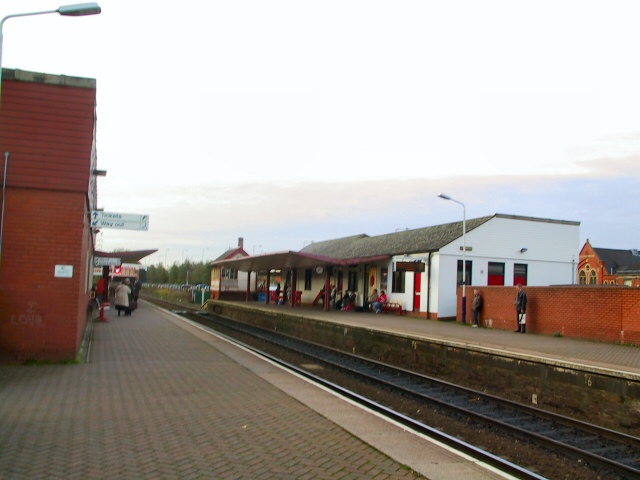
 Chorley railway station
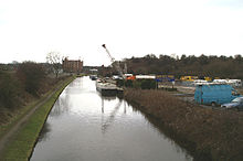 Leeds-Liverpool Canal, Chorley
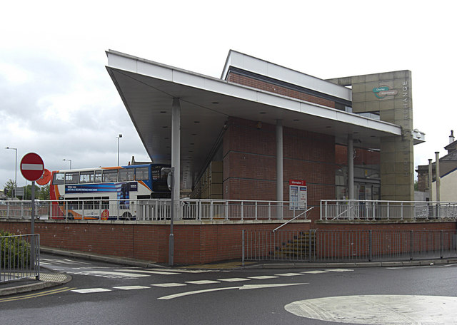
 Chorley Interchange
Road
Chorley is bisected by the A6 Roman road which goes straight through the town centre. The town is also near to the M61 of which Junction 6 and 8 serving the town. Also the M6 motorway serves the west of the town with Junction 27 connecting the town to the motorway, Charnock Richard Services on the M6 are located in Chorley Borough.
Bus
The town's bus station, Chorley Interchange, opened in 2003, replacing an older bus station also in the town centre. Bus services are provided by several operators:
- Stagecoach North West operate bus services which connect the town to Bolton, Blackburn, Preston and Manchester, and the Network Chorley routes within the borough.[7]
- Transdev Lancashire United operate the bus service between Blackburn and Chorley.
- Fishwick Buses connect Chorley bus station to Leyland and Preston.
- Arriva operate buses to Wigan.
- National Express also operate a daily service from Chorley Interchange to London.
Rail
The main central station is Chorley railway station in the town centre. The station is used by:
- First TransPennine North West whose line runs between Manchester Airport and Windermere and now links direct to Scotland without changing.
- Northern Rail Manchester to Preston Line runs through Chorley and also connects the town to Bolton, Preston and Manchester.
The station was also served by the Wigan-Blackburn Railway line up until it was closed in 1960. The line also had stops at Heapey, Brinscall, Withnell and the White Bear Station at Adlington.
Elsewhere in the borough there are stations at Euxton on the Wigan-Preston line, at Adlington and Buckshaw Village on the Manchester-Preston line, and at Croston on the Ormskirk Branch Line.
Waterways
The Leeds and Liverpool Canal runs parallel to Chorley and several marinas and locks are located on the Chorley area. Marinas along the canal include:
- White Bear Marina, Adlington
- Cowling Launch, Chorley
- Top Lock, Whittle
- Botany Bay, Botany Brow
- Riley Green, Hoghton
Education
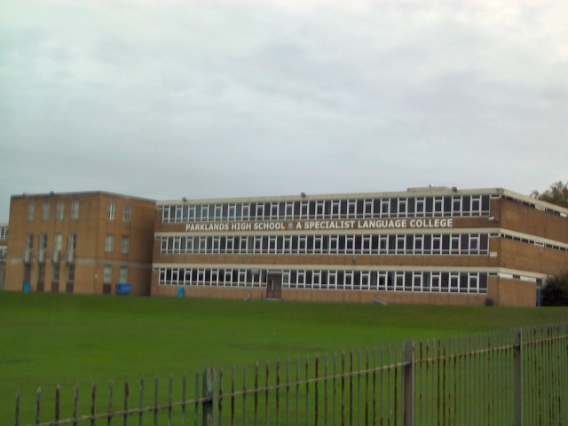
 Parklands High School, Chorley
Chorley is home to numerous primary schools both council and church supported. Chorley has the following 6 high schools:
- Holy Cross Catholic High School
- Albany Science College
- Bishop Rawstorne CE High School
- Parklands High School
- Southlands High School
- St. Michael's CE High School
Some independent schools are also present just outside the borough. Most Chorley children go on to attend the nearby Runshaw College in Leyland. Runshaw College has also expanded into the former administration site of ROF Chorley and is using, amongst others, the main Administration Building.
Lancashire College, based in Chorley, is a part of Lancashire County Council's Lancashire Adult Learning, offering a wide range of courses, a speciality being intensive residential language courses. From 1905 to 1981 the town was home to Chorley Training College (from the 1960s known as Chorley 'Day' Training College), designed by the Victorian and Edwardian architect Henry Cheers, and the town centre building now occupying this site is now Chorley Public Library.[8]
Sport
 Chorley Lynx F.C. Logo
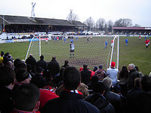 Victory Park, the home of Chorley Lynx Football Club
 Duxbury Golf Course, Duxbury Park
Chorley is home to the semi-professional football team, Chorley F.C., also known as the 'Magpies' due to their black and white strip. Founded as a rugby team in 1875, they switched to playing football eight years later. Since then they have had limited success, with their most memorable moments being two appearances in the second round of the FA Cup, and two seasons in the Football Conference in the late 1980s. They currently play in the Northern Premier League First Division.
The town and surrounding boroughs boast a number of cricket clubs, with two teams taking the town's name. Chorley Cricket Club currently play in the Northern League, and were finalists in the ECB National Club Cricket Championship for three consecutive seasons from 1994 to 1996, winning the trophy on the first two occasions. Chorley St James Cricket Club are the second side in the town, competing in the Southport & District Amateur Cricket League, having been members of the Chorley League until its demise in 2005.
Chorley RUFC was founded in the early 1970s and initially their matches were on the playing fields of Astley Park. Since there was no club house in the early days the team played from the Prince of Wales pub, near the town's covered market. Work started on a new clubhouse on 22 March 1984, on an area of land off Chancery Road, situated on the edge of the freshly constructed Astley Village Estate. The club currently run two senior sides and a mini section, the 1st XV playing in the RFU North Lancs 2 division.
Until 2004, Chorley also boasted a rugby league side, Chorley Lynx, who played in league two of the national league. However, the club was forced to close in 2004 due to small crowds and the withdrawal of funding by backer Trevor Hemmings. Many of the club's players and staff joined Blackpool Panthers, operating out of nearby Blackpool.
Chorley also boasts as being home to some of the countries most successful track cyclists including Jason Queally, Bradley Wiggins both Olympic gold medal winners and Rik Waddon Paralympic Silver Medalist. The town due to the Manchester Velodrome has become home to some of the biggest names in the sport. Chorley is also the home town of Paralympic Gold Medallist Natalie Jones.
In terms of local sporting facilities the town is home to Chorley Fitness, who was awarded UK Fitness Centre of the Year and UK King of Clubs at the 2007 Club Mirror Awards. They also boast BUPA accreditation and the largest and modern leisure facilities in Chorley. There's also a council owned leisure centre; All Season which contains a swimming pool, sports hall, squash courts and a small fitness suite. The borough also includes other gym facilities, two other council owned leisure centres; Clayton Green and Coppull and another public swimming pool at Brinscall. The town is also home to a Next Generation[disambiguation needed
 ] fitness centre and other private pools and leisure centres. It is also home to a David Lloyd Tennis Centre.
A mile south of Chorley town centre is Duxbury Park municipal golf course.
The town is also home to many amateur football, rugby and cricket teams. There are also several grass football pitches, bowling greens and tennis courts in the town. A public outdoor swimming pool did exist in Astley Park but was demolished in the 1990s due to Health and Safety fears.
Chorley are also home to the Chorley Harriers Running Club, who regularly compete in road, cross country, fell and athletics events.
Media
Nationally Chorley is often portrayed as a barometer of public opinion, especially during political campaigns as it has both a large rural and urban mix.
Chorley has two local newspapers: the weekly paid-for Chorley Guardian and the free Chorley Citizen. A British comedy television show, Phoenix Nights, cited Chorley's radio station, Chorley FM, whose slogan was "Coming in your ears". Chorley does have a radio station, (which is unconnected to the TV Series) The station based in Chorley originally broadcast for only a few weeks, but in 2005 received a licence to broadcast from Chorley Community Centre, for more information see Chorley FM.
As well as Phoenix Nights, comedian Dave Spikey based his comedy series Dead Man Weds on, and filmed most of it in, Chorley. Steve Pemberton, the creator of The League of Gentlemen, based most of its characters on folk from Adlington.
Seal Films, a local film production company brought an accolade to the town in 2001 after they were nominated for a Royal Television Society Award for a short film. The company continue to operate in Higher Wheelton.
Culture and Community
 Chorley Little Theatre
Chorley has two Historical Societies, The Chorley Historical and Archaeological Society and The Chorley and District Natural History Society. It also has a Civic Society.
Chorley Little Theatre was built as one of the town's first electric cinemas in 1910, it has been owned and operated by volunteers from Chorley Amateur Dramatic and Operatic Society (CADOS) since 1960. The society put on at least six productions a year (typically four plays, a pantomime, and a musical) and shows by Chorley Youth Theatre and big-screen films from Chorley Empire Community Cinema. It underwent refurbishment in 2010 and hosts touring comedy and music shows from old and new acts.
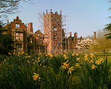
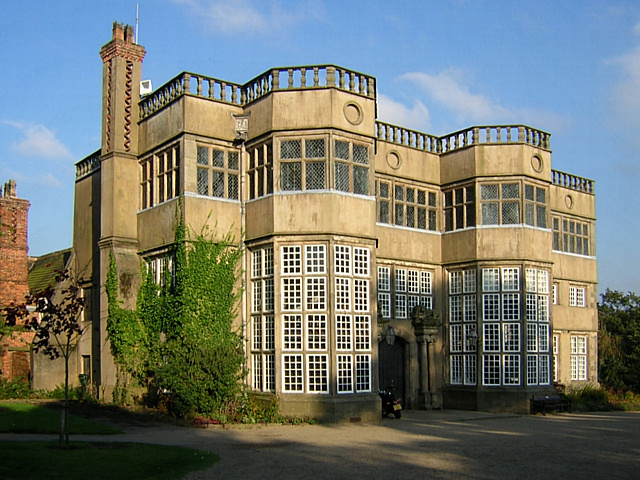
Astley Park, the town's urban, town centre park includes the Grade I listed, Astley Hall and also the renovated and refurbished Coach House Gallery and Walled Garden. The Coach House Gallery presents a seasonal programme of visual art's exhibitions from local and regional artists alongside an outdoor cultural events programme in the Walled Garden. These events include live music, theatre, dance and community arts events.
The Arts Partnership is a youth arts charity that operates from their own venue on Railway Street in the town centre. They run a number of arts and creative schemes with a diverse range of young people. The murals at the train and bus stations were produced as part of projects from the registered charity.
Cedar Farm Galleries in Mawdesley houses a number of artist's studios, retail stores and an on site restaurant.
Places of interest
Key 
Abbey/Priory/Cathedral 
Accessible open space 
Amusement/Theme Park 
Castle 
Country Park 
English Heritage 
Forestry Commission 
Heritage railway 
Historic House 

Museum (free/not free) 
National Trust 
Zoo  Astley Hall
- Astley Park & Astley Hall

- Bank Hall
 Bank Hall, Bretherton, a Jacobean mansion house, awaiting restoration. Home to Lancashire's oldest Yew tree and one of the two fallen sequoia in the UK. Open on limited open days arranged by the Bank Hall Action Group.
 - Botany Bay
- Buckshaw Village
- Camelot Theme Park
- Preston England Temple
- Duxbury Park
- White Coppice & The Great Hill

- Heskin Hall
- Heapey Nab
- Leeds & Liverpool Canal
- Park Hall
- St. Laurence's Church - the oldest building in Chorley[citation needed]
- Rivington Pike

- Winter Hill
- Worden Park
- Yarrow Valley Country Park
Notable residents
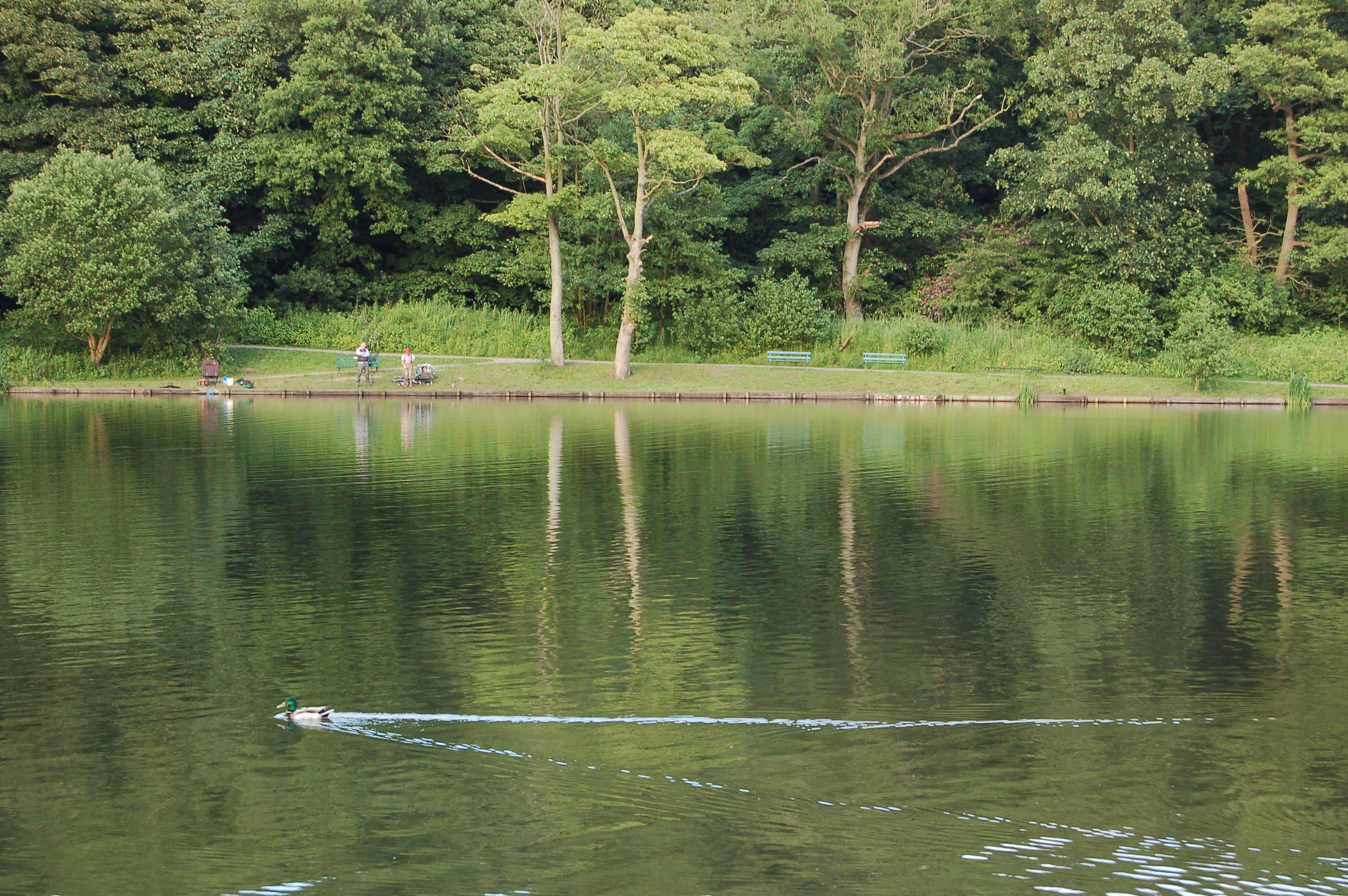
 Yarrow Valley Country Park
 Chorley Central Library
 Preston-England Mormon Temple
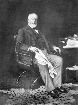
 Sir Henry Tate
- Loui Batley (actress and dancer)
- Bill Beaumont (former England rugby union captain)
- Walter Berg (astronomer/astrologer)
- Phil Cool (comedian)
- C. D. Darlington (biologist)
- Derek Draper (former Labour spin doctor and newspaper columnist)
- John Foxx (musician)
- Joseph Gilgun (actor)
- Paul Grayson (England rugby union player)
- Rick Guard (jazz singer and songwriter)
- Sir Walter Haworth (Nobel Prize winner)
- Trevor Hemmings (businessman)
- Conrad Hunte (former West Indian Test cricketer, lived in Chorley before the 1957 Test Series against England)
- Michael Jennings (boxer)
- Charles Lightoller (highest-ranking crew member to survive the RMS Titanic)
- Paul McKenna (footballer)
- Paul Mariner (England international footballer)
- Barry Mason (songwriter)
- Ken Morley (actor)
- Phil Parkinson (ex-footballer, now football manager)
- Steve Pemberton (comedian)
- Jason Queally (cyclist)
- Thomas Rawlinson (industrialist, believed to have been born in Chorley)
- Adrian Rigby (artist)
- Kevin Simm (musician, Liberty X)
- Tom Smith (cricketer)
- Dave Spikey (comedian)
- Myles Standish (founder of the Pilgrim Fathers)
- Starsailor (pop group)
- Tom Criddle Stephenson (journalist and champion of walkers' rights)
- Sir Henry Tate (sugar magnate and founder of the Tate Gallery, London)
- Joel Tomkins (rugby league footballer)
- Sam Tomkins (rugby league footballer)
- David Unsworth (former footballer and current Preston North End development coach)
- Mickey Walsh (former Irish international footballer)
- Lana Williams (dancer)
- Rosemarie Wright (pianist)
- Leonora Carrington (painter)
References
- ^ "Chorley Borough 2001 Population Census Report". Chorley Borough Council. http://www.chorley.gov.uk/CHttpHandler.ashx?id=224&p=0. Retrieved 2011-05-18.
- ^ Workhouse, Workhouses.org, http://www.workhouses.org.uk/index.html?Chorley/Chorley.shtml, retrieved 2010-12-07
- ^ http://hansard.millbanksystems.com/lords/1971/feb/03/central-lancashire-new-town
- ^ http://www.centrallancscity.org.uk/design/indexa.asp?page=page_3
- ^ "Buckshaw Village plan announced". Leyland Guardian (Johnston Publishing). 2008-08-26. http://www.leylandguardian.co.uk/news/local/buckshaw_village_plan_announced_1_2021925. Retrieved 2011-09-05.
- ^ "Market Walk On Hold". Chorley Borough Council. 2008-01-17. http://www.chorley.gov.uk/index.aspx?articleid=2614. Retrieved 2008-02-09.
- ^ "Network Chorley bus times". Lancashire County Council. 2009-11-29. http://www.lancashire.gov.uk/environment/documents/transport/266.pdf. Retrieved 2011-06-07.
- ^ "Welcome to the Library and Information Service web site - History of Chorley". Lancashire County Council. http://www.lancashire.gov.uk/libraries/librarydetails/libhist.asp?name=Chorley. Retrieved 2008-02-26.
External links
- Chorley Borough Council
- Chorley and District Natural History Society
- Chorley Historical and Archaeological Society
- Chorley at the Open Directory Project
Ceremonial county of Lancashire North West England Portal Unitary authorities Boroughs or districts Major settlements Accrington • Adlington • Bacup • Barnoldswick • Blackburn • Blackpool • Brierfield • Burnley • Burscough • Carnforth • Chorley • Clayton-le-Moors • Cleveleys • Clitheroe • Colne • Darwen • Earby • Fleetwood • Garstang • Great Harwood • Haslingden • Kirkham • Lancaster • Leyland • Longridge • Lytham St Annes • Morecambe • Nelson • Ormskirk • Oswaldtwistle • Padiham • Penwortham • Poulton-le-Fylde • Preesall • Preston • Rawtenstall • Rishton • Skelmersdale • Wesham • Whitworth
See also: List of civil parishes in LancashireRivers Canals Topics Categories:- Market towns in Lancashire
- West Pennine Moors
- Chorley
- Towns in Lancashire


Wikimedia Foundation. 2010.