- Duxbury Woods
-
Coordinates: 53°37′59″N 2°37′26″W / 53.633°N 2.624°W
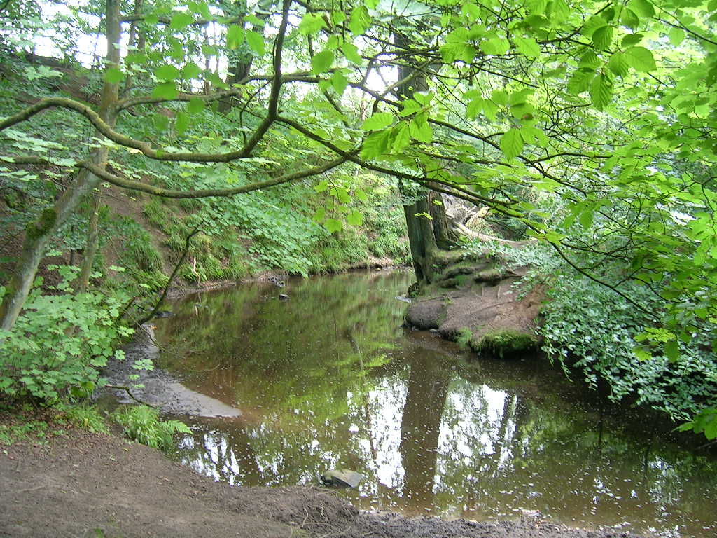
 The River Yarrow in Duxbury Woods
Duxbury Woods is an area of woodland and parkland situated in Chorley, Lancashire, at the foot of the West Pennine Moors. The area originally existed as a township with the council meeting at the Yarrow Bridge pub; this was absorbed into Chorley Rural Council in the early 20th century.
Duxbury today is home to Duxbury Jubilee Park, Duxbury Golf Course, the woods and the River Yarrow. It was also home to Duxbury Hall, the seat of the Standish family. The estate and grounds still exist with the gardens, stables, coachhouse, 16th century barn and Lodges on Bolton Road and Wigan Lane remaining. The Hall itself was built in the 17th Century, and was demolished to make way for housing in 1957. Many consider the great barn (which remains) to be the original home of the pilgrim father Myles Standish.
History
Duxbury has existed with this name (Deuksburie, Dokesbirie, etc.) since an Angle named Deowuc settled there in 600-900 AD, before the arrival of Vikings at the latter date. He is believed during the rule of King Offa to have set up a fortified farm known as a burh on land near the present day Saw Mills on Wigan Lane.
The first Old Hall was in the south of Duxbury (many believe on the site of Bretters Farm near to the Leeds-Liverpool Canal) and the Elizabethan Hall in the centre of the manor was built c. 1600 (many think this was the home of Myles Standish).
Other buildings include game preserves, stables and coachhouses. A peel tower was constructed in the north of Duxbury during the Anglo-Scottish wars of the 14th century (documents suggest 1319). The rectangular hall pictured was first built in the 17th century, with many later modifications, but was demolished in the 1950s. The site of the manor is now home of Duxbury Jubilee Golf Course. The Great Hall (known as the barn) is now home of Dodd architects and the stables and coachhouses are home to council offices. A conservatory and various other buildings within the manor wall were built for Chorley Rural Council but are now used as staff blocks for the Golf course staff.
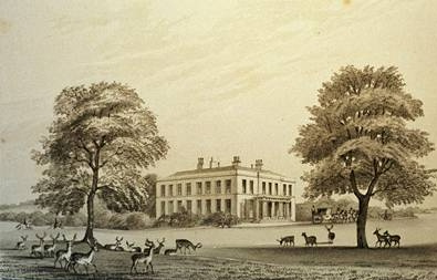
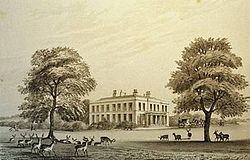 Duxbury Hall as it looked in 1840
The woodland was home to Duxbury Mill which ground corn. Today only traces can be found deep into the woodland at the edge of Red Bank Lane off Carr Lane on the grounds of the Vertex Centre. The weir and mill race which powered the mill still exist and can be seen from the Yarrow Bridge. As well as the mill four coal mines existed; Duxbury Park, Duxbury, Carr and Yarrow Collieries existed. Duxbury Park's old railway bridge ruins can still be seen on Wigan lane. This means there are many tunnels underneath Duxbury with many now disappeared. The latter three collieries were all located around the grounds of the Marconi factory and Vertex Centre whilst Duxbury Park was located near to Wigan Lane.
Some of Duxbury is now part of the Yarrow Valley Park which also includes the nearby Birkacke lodges and the large Burgh estate which was once owned by Duxbury Hall.
Today the parkland is home to the Chorley Red Bank Scout Group, who meet at the (St Georges) Red Bank Mission. This building was formerly used to serve the workers of the collieries of Carr Lane.
Eaves Green Link Road
A new link road is set to destroy some of Duxbury's woodland including the site of the former Duxbury Corn Mill and the former Duxbury Collieries. This also crosses the old Red Bank settlement and old Bolton road which still exists for around 900 yards between the Marconi factory and the Scout Hut.
The construction process began on the 4th of December 2006 and is due to be complete by December 2007. The road is set to provide links to Holy Cross High and the Vertex training centre as well as providing future housing and factory sites.
See also
- Official Duxbury link road website
- History page dedicated to Duxbury Hall
- Red Bank Scout Group Bonfire Website
- William Farrer & J. Brownbill (editors) (1911). "Townships: Duxbury". A History of the County of Lancaster: Volume 6. Victoria County History. pp. 208–13. http://www.british-history.ac.uk/report.asp?compid=53099. Retrieved 2007-08-03.
Categories:- Parks and commons in Chorley
- West Pennine Moors
Wikimedia Foundation. 2010.