- Mid-October 2007 tornado outbreak
-
October 2007 tornado outbreak Heavy structural damage in Nappanee, Indiana on October 18, 2007 (Courtesy of NWS Northern Indiana)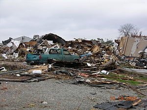
Date of tornado outbreak: October 17–19, 2007 Duration1: 31 hours, 46 minutes Maximum rated tornado2: EF3 tornado Tornadoes caused: 64 confirmed[1] Damages: $53 million[1] Fatalities: 5[1] Areas affected: Midwest and Southern US 1Time from first tornado to last tornado
2Most severe tornado damage; see Enhanced Fujita ScaleThe Mid-October 2007 tornado outbreak was a widespread tornado outbreak that took place across much of the eastern half of North America starting on October 18, 2007 and continuing into the early hours of October 19. The outbreak was also responsible for five deaths; three in Michigan and two in Missouri, plus many injuries (including some from non-tornadic events). At least 64 tornadoes were confirmed including 16 on October 17 across six states including Texas, Oklahoma, Arkansas, Louisiana, Mississippi and Missouri with wind damage reported in Oklahoma, Kansas, Illinois, Iowa, Arkansas and Mississippi. On October 18, at least 48 tornadoes were confirmed across eight states including Florida, Alabama, Mississippi, Tennessee, Kentucky, Illinois, Indiana and Michigan, plus widespread straight line wind damage.[2][3] It was the largest tornado outbreak ever recorded in the month of October according to NOAA.[4]
Contents
Meteorological synopsis
 A tornadic supercell east of Lewisport, Kentucky. Strong wind shear aloft held cloud heights to a maximum of 40,000 feet (12,000 m)
A deep low pressure system (with a pressure of 977 mbar at its peak[5]) moved across the Pacific Coast on October 15 and then crossed the Rockies during the following day and touched out some moist air from the Gulf of Mexico, major source for storm development and intensification. Not part of the main outbreak, 3 tornadoes were reported, during the overnight hours of October 16 towards October 17, across Randall County, Texas south of Amarillo on October 16 with 1 of them confirmed as a high EF1. That tornado caused damage to trees, fences, power poles, steel pipes, trailers and barns.[6][7]
The next day a dry line, which separates the drier air from the more moist and humid air, formed ahead of the cold front across the Texas and Oklahoma Panhandles and tracked eastward.[8] The high humidity levels with dew points in the 70s°F (low 20s°C), temperatures that in many areas were near 80°F (27°C), strong wind shear and the presence of the dry line helped developed the instability to produced severe thunderstorms across the Midwest and Southern Plains on October 17.[9][10]
A moderate risk for severe weather was issued by the Storm Prediction Center two days prior to the event.[11] The storm then moved across the most of the Midwest on October 18, where a moderate risk was in effect also for two days for most of Illinois, Indiana and parts of Kentucky, although the moderate risk was revised further to the south and east to include western Ohio, western Tennessee, southeastern Missouri, northeastern Arkansas and a larger portion of Kentucky while Michigan and Wisconsin were no longer under a moderate risk.[12][13] A slight risk of severe weather was forecast for a very large area from beyond the Canadian border to the Florida Panhandle and Mobile Bay.[13] Dew points above 70°F (21°C) were reported well into the Ohio Valley,[14] and dew points above 60°F (16°C) were reported as far north as northern Ontario.[5]
The outbreak was expected to continue into October 19 east of the Appalachians, however, extensive cloud cover prevented any significant severe storms from developing although several wind reports were reported in Pennsylvania, New Jersey and Massachusetts.[15] The storm then moved out into the Atlantic Ocean on October 20.
Significant tornadoes
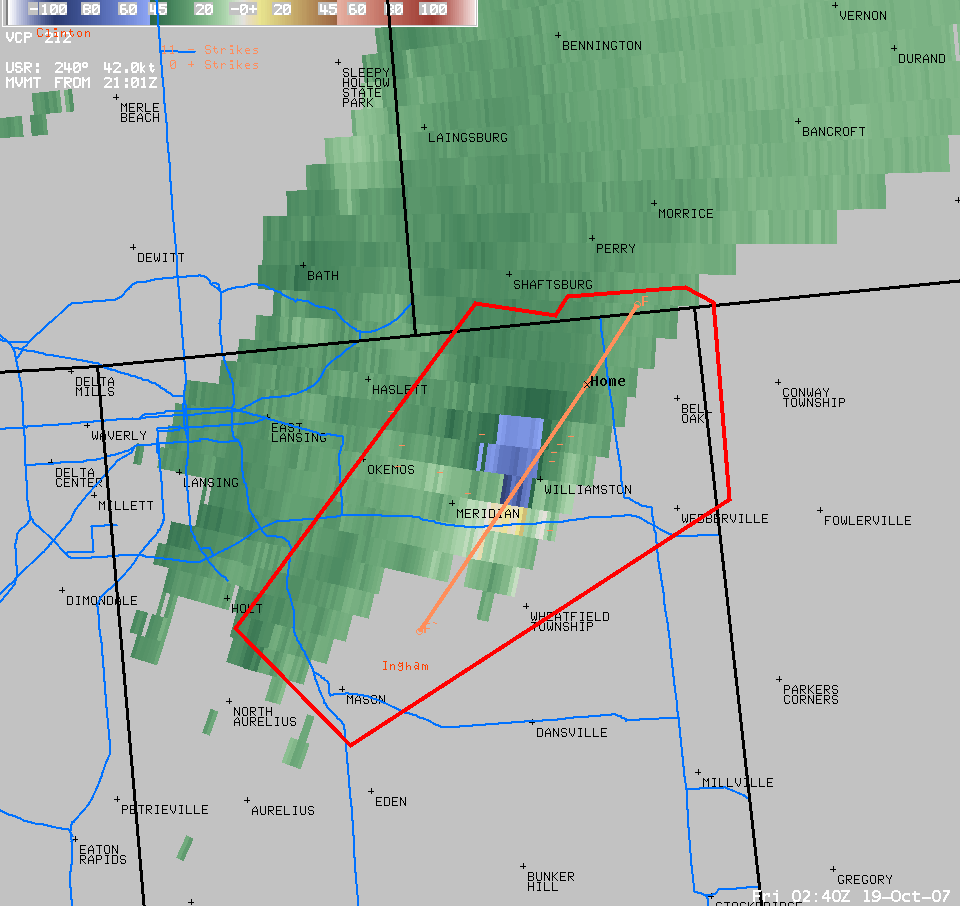
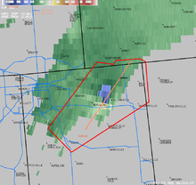 Graphic showing the track of the Ingham County, Michigan tornado (Courtesy of NWS Grand Rapids, Michigan)
The first severe thunderstorms developed during the early morning of October 17 across much of northern and eastern Texas and parts of Oklahoma and Kansas with only one reported tornado in east Texas.[2] Several severe thunderstorms then later developed across eastern Oklahoma, Arkansas, Louisiana, western Mississippi, eastern Kansas, Missouri and parts of Nebraska, Iowa, Kentucky, Illinois and Tennessee.[2] Twelve additional tornadoes were reported in Missouri and Louisiana during the late afternoon and early evening with damage reported in Lawrence and Greene counties in Missouri.[2] One of the tornadoes located near Verona destroyed several barns and homes but did not cause any injuries and was later confirmed as an EF2.[16] The storms persisted throughout the night and an additional tornado killed 2 people inside a mobile home in Greene County, Missouri near Paris.[17]
 House heavily damage by a tornado in Hubbard Lake, Michigan (courtesy of NWS Gaylord, Michigan)
On October 18, several thunderstorms already developed during the morning hours and continued to intensify during the afternoon.[3] Just after 11:00 am EDT, one tornado in downtown Pensacola, Florida caused some extensive damage to the roof of a Baptist church as well as portions of Cordova Mall but there were no reported injuries at the Church and daycare center.[18] During the early evenings severe weather affected the Louisville, Kentucky Metro area in which tree damage and power outage were reported throughout the area and a possible tornado at around 7:00 pm EDT near the Crescent Hill area which was later confirmed as a brief EF0.[19] Still in the region, one tree fell over a passing car but the motorist escaped injuries even he was trapped for several minutes inside.[20] The Louisville power authority, the LG&E reported as much as 2,500 homes without power mostly in St. Matthews and Crescent Hill areas.[20] More storms rolled through much of the Ohio and Tennessee Valleys during the second half of the evening and overnight with more storms in Michigan.[2]
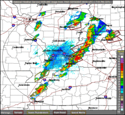 Paducah, Kentucky radar loop showing the supercells in western Kentucky between 7:00 PM CDT and 7:45 PM CDT (Courtesy of NWS Paducah, Kentucky)
Areas the hardest hit were along and near the Ohio River in western Kentucky as well as central and northern Indiana in Nappanee where injuries were reported as well as significant damage,[21][22] and in Central Michigan.[23] Three people were killed overall on October 18: one in Kalkaska County, Michigan[24] and two in Locke Township, near Williamston, Michigan.[25] In addition to the tornadoes, storm straight line damaging wind measured up to 80 mph (130 km/h) were recorded across several of the regions hit by the severe weather, causing extensive tree and power line with isolated reports of structural damage.[2]
In Michigan, a tornado in Tuscola near Flint threw a one year old baby 40 feet (12 m) away from its location along with the crib and was later found amongst a pile of rubble under a mattress. His parents told reporters that the mattress saved the toddler's life and he suffered few to no injuries.[26] According to the National Weather Service in Detroit, tornadoes this late in the year in Michigan are very rare.[27] The last significant October tornado event was on October 24, 2001, when three tornadoes hit southeastern Lower Michigan, out of a total of nine in the state that day.[28] Including the 2001 tornadoes, only seven October tornadoes had been recorded in the NWS Detroit county warning area prior to the 2007 outbreak. By comparison, NWS Detroit had confirmed five tornadoes in its coverage area from this outbreak.[23] It was also the largest October outbreak over western Kentucky and southern Indiana as 15 tornadoes were confirmed on October 18. Previous to this outbreak, only 19 tornadoes had been recorded in that same region during the history of October prior to this event.[29] The Owensboro tornado, which was rated an EF3 was also the strongest ever in that month over the same region since records were kept in 1950 although an unofficial F3 took place in Posey County, Indiana on October 16, 1928.[29]
Tornadoes confirmed
Confirmed
TotalConfirmed
EF0Confirmed
EF1Confirmed
EF2Confirmed
EF3Confirmed
EF4Confirmed
EF564 20 26 15 3 0 0 October 17 event
List of reported tornadoes - Wednesday, October 17, 2007 F# Location County Time (UTC) Path length Damage Texas EF1 W of Ogg Randall 0516 11 miles
(17.6 km)Damage to several barns, fencing, a trailer, a homestead and power poles. Two large diesel tanks were also moved. EF0 SW of Buna Jasper 1532 1 miles
(1.6 km)Brief touchdown with damage to trees Missouri EF0 W of Centerview Johnson 2105 unknown Brief touchdown with no damage EF2 N of Verona Lawrence 2250 11 miles
(17 km)Intermittent damage path. Nine houses damaged or destroyed, along with a lumber mill and several barns. EF1 N of Cave Springs Greene 2335 3 miles
(4.8 km)Two houses and a barn were damaged or destroyed. EF0 S of Lebanon Laclede 0435 unknown Damage reported to a mobile home and the roof of a house. EF0 E of Hatton Callaway 0455 1 miles
(1.6 km)A horse stable, a double wide mobile home, a large garage and trees were damaged EF0 S of Madison Monroe 0500 4 miles
(6.4 km)Two machine sheds were damaged as the tornado tracked across mostly farmland. EF2 NW of Paris Monroe 0505 4 miles
(6.4 km)2 deaths - A mobile home was thrown, killing its occupants. A large barn and machine shed were also destroyed. EF0 N of Paris Monroe 0507 2 miles
(3.2 km)Damage to trees and a machine shed. Oklahoma EF0 NE of Fort Tawson Choctaw 2214 unknown Brief tornado over open country with no damage Louisiana EF1 Franklinton Washington 2245 unknown Three windows suffered window and roof damage EF1 N of Franklinton Washington 2255 unknown A mobile home had roof damage and several trees were uprooted Arkansas EF1 W of Star City Lincoln 2302 5.4 miles
(8.6 km)Six mobile homes were damaged or destroyed and four houses sustained minor damage. Widespread tree and power line damage. Mississippi EF1 NE of Society Hill Jefferson Davis 0030 0.33 mile
(550 m)One house and two storage buildings lost their roofs. EF1 N of Hattiesburg Forrest 0110 1.5 miles
(2.4 km)Tornado began at Exit 69 on I-59, where a car was blown off injuring the occupant. Roof damage was reported to two houses and a garage. EF0 Tolarville area Holmes 0303 2 miles
(3.2 km)Several trees were downed Sources: Storm reports of October 17, 2007 NWS Springfield, NWS St. Louis, NWS Little Rock, NWS Jackson MS, NOAA Storm Data
October 18 event
List of reported tornadoes - Thursday, October 18, 2007 F# Location County Time (UTC) Path length Damage Mississippi EF1 W of Vancleave Jackson 1045 1.8 miles
(3 km)Two mobile homes were destroyed, along with numerous outbuildings. Heavy tree and power line damage. EF0 Starkville Oktibbeha 1741 0.1 mile
(160 m)Brief tornado, minor damage to a building at the Starkville Country Club. EF0 E of Starkville Oktibbeha 1804 unknown Tornado touchdown recorded in an open field. No significant damage. EF1 N of De Kalb Kemper, Noxubee 1913 3 miles
(4.8 km)Damage limited to pine trees being knocked down. EF0 SE of Thornton Holmes 0208 2 miles
(3.2 km)Narrow path of tree damage. Florida EF1 Pensacola Escambia 1513 7 miles
(11 km)Tornado first touched down near Pensacola Naval Station, also tracking through downtown Pensacola and a commercial area, especially Cordova Mall. 86 buildings were damaged by the tornado. Four people were injured. Alabama EF0 NW of Vernon Lamar 1815 unknown Brief tornado touchdown photographed by police. The tornado did not caused any damage. EF0 SW of Haleyville Marion 1951 0.06 mile
(100 m)A farmhouse was damaged, and tree and powerline damage was reported. EF1 NE of Haleyville Lawrence 2005 0.15 mile
(250 m)Tornado reported in the Bankhead National Forest, damaging trees. Michigan EF1 W of Tower Cheboygan 2125 10 miles
(16 km)Damage reported near Black Lake, including a barn destroyed. EF2 NE of Long Rapids Alpena 2225 4 miles
(6.4 km)Three houses were damaged, and three barns and a shed were destroyed. Significant tree damage also reported. EF2 SW of Kalkaska Kalkaska 2335 5 miles
(8 km)1 death - Numerous houses were damaged or destroyed, including a mobile home where the fatality occurred. Severe damage also reported at the Kalkaska County Airport. EF2 E of Luzerne Oscoda 0012 14 miles
(22 km)Large wedge tornado damaged 15 houses. Hundreds of trees were snapped or uprooted. EF1 E of Luzerne Oscoda, Alcona 0042 3 miles
(4.8 km)Considerable tree damage. Related to Luzerne tornado. EF2 N of Hubbard Lake Alpena 0100 0.25 mile
(400 m)One house was heavily damaged and two barns and a mobile home were destroyed. EF2 SE of Williamston Ingham, Shiawassee 0228 19 miles
(30.4 km)2 deaths - Two people were found the following morning after they being thrown out of their modular home into a nearby pond. A tractor-trailer was thrown on I-96. EF1 SSW of Millington Tuscola 0515 2 miles
(3.2 km)Reported by law enforcement. According to the Associated Press, a year-old baby inside his crib was thrown 40 feet (12 m) by the tornado but escaped injuries in Millington Township.[26] EF0 E of Clio Genesee 0516 2.5 miles
(4 km)Shingle damage to one home EF1 W of Deford Tuscola 0545 3 miles
(4.8 km)SPC Storm Reports web page listed tornado twice; second listing was erroneous duplication of report with incorrect location; NWS Detroit damage survey report and storm report list does not include duplicate report. EF1 W of Port Hope Huron 0630 1 mile
(1.6 km)Substantial damage to farm buildings, heavy farm machinery lifted and displaced. Not listed in preliminary reports, but found during damage surveys. Illinois EF0 NE of West Salem Edwards 2215 unknown Brief touchdown according to trained spotters and several officials. No damage was found. Kentucky EF1 NE of Owensboro Daviess 2307 2 miles
(3.2 km)A few structures were damaged. EF0 Louisville Jefferson 2310 unknown Tornado touched down at a Kroger store in the Crescent Hill area. Damage limited to that commercial structure. EF2 S of Lewisport Daviess, Hancock 2310 13.2 miles
(21 km)Long track tornado with multiple touchdowns. Numerous trees and several buildings damaged. EF0 SW of Gatewood Daviess 2315 1 miles
(1.6 km)Several trees were damaged EF2 Sebree area Webster 0009 10.4 miles
(16.5 km)Major damage reported inside the city limits, including numerous houses damaged or destroyed. EF1 E of Creswell Caldwell 0020 unknown Trees uprooted and snapped EF2 S of Dawson Springs Caldwell 0025 unknown Roof damage to several houses and several barns destroyed. Some uprooted trees fell on houses. EF2 SW of Owensboro McLean, Daviess 0032 17.5 miles
(28 km)Many houses damaged or destroyed. EF2 SE of Dawson Springs Christian 0040 2 miles
(3.2 km)Widespread tree damage reported in the Pennyrile State Forest. One mobile home was damaged on Highway 109. EF2 E of Dawson Springs Hopkins 0050 1.5 miles
(2.4 km)Three mobile homes were destroyed. One house and several barns were damaged, partially by flying debris. EF1 Nortonville Hopkins 0100 2 miles
(3.2 km)Damage to several buildings in town, including two houses and a gas station. Widespread tree damage. EF1 Blue Spring Trigg 0102 2.5 miles
(4 km)Damage reported near Lake Barkley State Park to a house, cabin, garage and boat dock (some of the damage due to fallen trees). EF1 NW of Hamlin Calloway 0107 7.4 miles
(12 km)Late report. One house heavily damaged primarily from fallen trees. EF3 Owensboro area Daviess 0109 7.5 miles
(12 km)Major damage in the city with many houses and businesses damaged or destroyed. Eight people were injured. EF0 SW of Linton Trigg 0123 1 mile
(1.6 km)Damage to trees in the Land Between the Lakes area. No structures affected. EF2 S of Cadiz Trigg 0132 10.5 miles
(17 km)Two barns destroyed and debris thrown up to 3/4 mile (1.2 km) away. Many trees blown down. EF2 Rosetta Breckinridge 0226 3 miles
(4.8 km)A church was destroyed, and several houses suffered heavy damage. Three large vehicles were thrown into the air. EF1 Fort Knox Meade 0250 2.5 miles
(4 km)Many trees were uprooted and twisted. Two businesses sustained roof damage. EF1 Hubers area Bullitt 0320 2 miles
(3.2 km)Significant damage to outbuildings, sheds, two houses and one garage. EF0 Bradfordsville Marion 0636 0.5 mile
(800 m)One mobile home was rolled over and several houses lost shingles. Indiana EF1 NE of Cannelton Perry 2334 5 miles
(8 km)Minor damage mostly in the Cann Heights Road area. Originally considered a continuation of the Hancock County, KY tornado but reclassified as two separate tornadoes. EF0 N of Ambia Benton 0035 unknown Brief touchdown in an open field with no damage EF1 SE of St. Marks Dubois 0127 2 miles
(3.2 km)A door from a house was blown off and a barn was damaged. About 100 trees were snapped. EF3 New Washington Clark 0203 4.8 miles
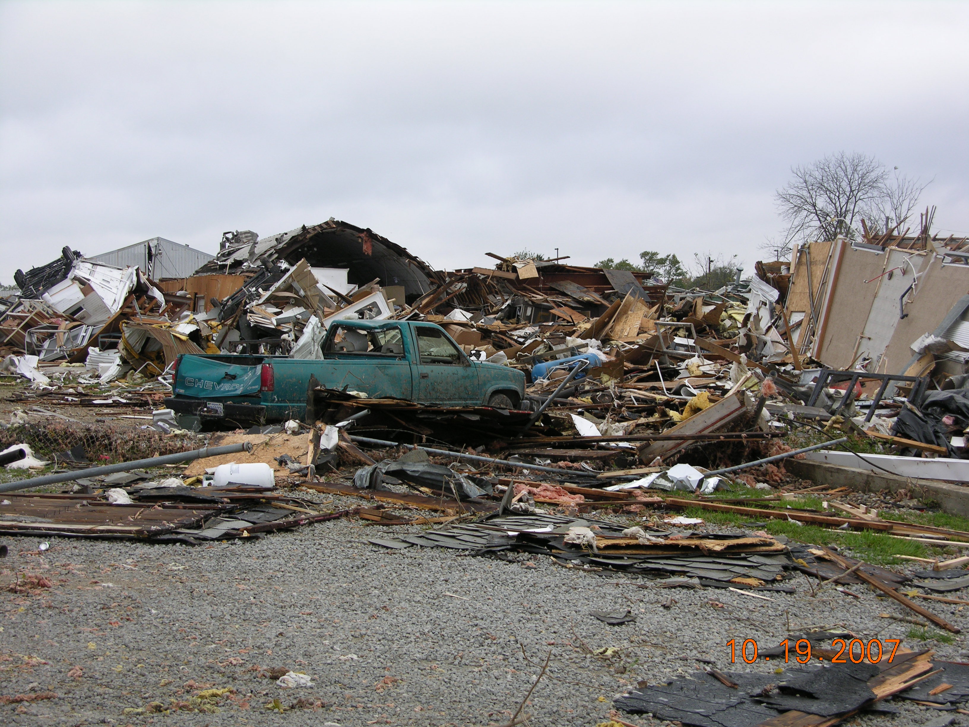
(7.7 km)One house was completely destroyed and 10 houses were damaged, some heavily. Numerous barns and outbuildings were destroyed. Initially rated as an EF2 before further surveys in New Washington discovered low-end EF3 damage.[30] EF3 Nappanee area Marshall, Kosciusko, Elkhart 0218 20 miles
(32 km)Severe damage took place in the area. 591 buildings (including at least 368 homes and 81 businesses) were damaged, of which at least 98 were destroyed across the three counties. Some of the heavily damaged buildings were three RV factories and numerous fast food outlets. Significant damage was also reported to many farms, with barns blown down and outbuildings destroyed, and farm animals were killed. Eight people were injured.Damages were estimated between $25–35 million.[31][32][33] Tennessee EF1 W of Model Stewart 0118 1 miles
(1.6 km)Numerous trees snapped and uprooted. Sources: Storm reports of October 18, 2007 NWS Michigan Offices (Combined report) NWS Northern Indiana summary, NWS Louisville summary NWS Central Illinois summary NWS Chicago summary NWS Paducah storm reports NWS Paducah summary NWS Tulsa summary NOAA Storm Data
Nontornadic events
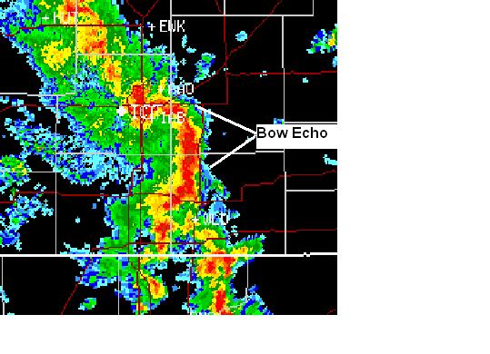
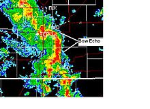 Radar shot of a bow echo crossing the Wichita area at 6:00 PM CDT on October 17, 2007. (Courtesy of NWS Wichita, KS)
In addition to the tornadoes, widespread straight-line wind damage took place across much of the affected region, particularly on the night of October 17 as a result of a derecho that moved across the southern Great Plains into the Ozarks. Winds were reported as high as 100 mph (160 km/h) as a result of the bow echo that moved across the region.[34] Tulsa was hard hit, with at least 55 people injured (one critically) due to wind damage at the Oktoberfest event. Many mobile homes were destroyed, and widespread power outages were reported in the region including in Rogers County near Oologah where five people where injured.[35]
 A thunderstorm with a confirmed tornado approaching Owensboro, Kentucky
In Kansas, a bow echo caused some localized significant damage in and around the Wichita Metropolitan Area with the most significant damage at the International Cold Storage located in the Andover area where the peak winds were measured.[34] Overall, over 400 wind reports in the US alone, were reported on both October 17 and 18 across the Midwest, Gulf Coast and Great Lakes with several reports of damage but there were no direct non-tornadic fatalities. In Chicago, an eleven year old boy was struck and injured by lightning while another person was injured by broken glass when high winds blew up windows of a lobby hall of a condominium.[26]
In addition, the Gulf Coast region, particularly the Florida Panhandle, received torrential rain due to continuous thunderstorms ahead of the cold front.[36] Rainfall amounts over 12 inches (300 mm) were common (with amounts as high as 22 inches (560 mm) were reported in Gulf Breeze, Florida), although only minor flooding was reported including roads and some houses flooded.[36]
See also
References
- ^ a b c "NCDC storm events". National Climatic Data Center. http://www4.ncdc.noaa.gov/cgi-win/wwcgi.dll?wwevent~storms. Retrieved 2008-04-28.
- ^ a b c d e f Storm Prediction Center (SPC) (October 17, 2007). "Storm Reports for October 17, 2007". http://www.spc.noaa.gov/climo/reports/071017_rpts.html. Retrieved 2008-05-19.
- ^ a b SPC (October 18, 2007). "Storm Reports for October 18, 2007". http://www.spc.noaa.gov/climo/reports/071018_rpts.html. Retrieved 2008-04-13.
- ^ "NOAA Reports Record-Setting Tornado Outbreak for October". NOAA. 2007-10-31. http://www.noaanews.noaa.gov/stories2007/20071031_tornado.html. Retrieved 2008-04-13.
- ^ a b "Archive of United States (CONUS) Analyses - 09Z October 19" (GIF). Hydrometeorological Prediction Center (HPC). 2007-10-19. http://www.hpc.ncep.noaa.gov/archives/sfc/namussfc2007101909.gif. Retrieved 2008-04-13.
- ^ SPC (October 16, 2007). "SPC Storm Reports for 10/16/07". http://www.spc.noaa.gov/climo/reports/071016_rpts.html.
- ^ NWS Amarillo, Texas (October 18, 2007). "Public Information Statement". http://www.srh.noaa.gov/ama/october17tornado/LBBPNSAMA.190128.
- ^ "Archive of United States (CONUS) Analyses - 18Z October 17" (GIF). HPC. 2007-10-17. http://www.hpc.ncep.noaa.gov/archives/sfc/namussfc2007101718.gif. Retrieved 2008-04-13.
- ^ "Archive of United States (CONUS) Analyses - 21Z October 17" (GIF). HPC. 2007-10-17. http://www.hpc.ncep.noaa.gov/archives/sfc/namussfc2007101721.gif. Retrieved 2008-04-13.
- ^ Hales (2007-10-17). "Tornado Watch #711". SPC. http://www.spc.noaa.gov/products/watch/2007/ww0711.html. Retrieved 2008-04-15.
- ^ Keer (2007-10-16). "Oct 16, 2007 1730 UTC Day 2 Convective Outlook". SPC. http://www.spc.noaa.gov/products/outlook/archive/2007/day2otlk_20071016_1730.html. Retrieved 2008-04-13.
- ^ Darrow (2007-10-17). "Oct 17, 2007 1730 UTC Day 2 Convective Outlook". SPC. http://www.spc.noaa.gov/products/outlook/archive/2007/day2otlk_20071017_1730.html. Retrieved 2008-05-19.
- ^ a b Broyles (2007-10-18). "Oct 18, 2007 2000 UTC Day 1 Convective Outlook". SPC. http://www.spc.noaa.gov/products/outlook/archive/2007/day1otlk_20071018_2000.html. Retrieved 2008-05-19.
- ^ "Archive of United States (CONUS) Analyses - 21Z October 18" (GIF). HPC. 2007-10-18. http://www.hpc.ncep.noaa.gov/archives/sfc/namussfc2007101821.gif. Retrieved 2008-04-13.
- ^ SPC (October 19, 2007). "SPC Storm Reports for October 19, 2007". http://www.spc.noaa.gov/climo/reports/071019_rpts.html. Retrieved 2008-04-13.
- ^ NWS Springfield, Missouri (October 18, 2007). "Severe Weather and Tornadoes Hit Southeast Kansas & Missouri Ozarks...". http://www.crh.noaa.gov/crnews/display_story.php?wfo=sgf&storyid=10637&source=0. Retrieved 2008-04-13.
- ^ KRCG 13 (October 18, 2007). "Two killed in possible tornado". http://www.krcgonline.com/news/news_story.aspx?id=57975. Retrieved 2008-04-13.
- ^ News4Jax.com (October 18, 2007). "Tornado Rips Pensacola; Storms Sweep Through Panhandle". http://www.news4jax.com/news/14369154/detail.html. Retrieved 2008-04-13.
- ^ NWS Louisville, Kentucky (April 15, 2008). "EF-0 Tornado Confirmed in Metro Louisville". http://www.crh.noaa.gov/lmk/?n=louisvillepns. Retrieved 2008-04-15.
- ^ a b English, Lindsey (October 19, 2007). "Tree crushes car but driver escapes". http://www.wave3.com/Global/story.asp?S=7236200&nav=menu31_3. Retrieved 2008-04-13.
- ^ WEHT 25 (Evansville, Indiana) (October 19, 2007). "Webster County Slammed by Storms". http://www.news25.us/dsp_story.cfm?storyid=3618&RequestTimeout=500. Retrieved 2008-04-13.[dead link]
- ^ WAVE 3 (Louisville) (October 19, 2007). "Nappanee hit hard by suspected tornado". http://www.wave3.com/Global/story.asp?S=7236801&nav=menu31_3. Retrieved 2008-04-13.
- ^ a b NWS Detroit, Michigan (October 19, 2007). "Late Season Tornado Outbreak October 18 & 19 - Updated for Genesee and Millington Tornadoes". http://www.crh.noaa.gov/crnews/display_story.php?wfo=dtx&storyid=10667&source=0. Retrieved 2008-04-13.
- ^ WXYZ Detroit (October 19, 2007). "TWISTER: Violent Storms Batter State". http://www.wxyz.com/news/local/story.aspx?content_id=1a2bc14a-9bac-4af3-979e-e2022fd274e6and.
- ^ Lansing State Journal (October 19, 2007). "Two people confirmed dead after Thursday storm". http://www.lsj.com/apps/pbcs.dll/article?AID=/20071019/NEWS01/710190353. Retrieved 2008-04-13.
- ^ a b c CNN (October 19, 2007). "Storms' death toll up to 6". Archived from the original on December 25, 2007. http://web.archive.org/web/20071225201342/http://edition.cnn.com/2007/US/weather/10/19/severe.weather/index.html. Retrieved 2008-04-13.
- ^ NWS Detroit, Michigan (April 15, 2008). "Tornado Outbreak on October 18–19, 2007". http://www.crh.noaa.gov/dtx/?n=oct18tor. Retrieved 2008-04-15.
- ^ National Weather Service. "Storm Data and Unusual Weather Phenomena: October 2001, Michigan" (PDF). http://www.crh.noaa.gov/images/dtx/stormdata/2001/October2001.pdf. Retrieved 2008-04-13.
- ^ a b NWS Paducah, Kentucky (October 22, 2007). "Last week’s tornado outbreak largest on record for October in our region". http://www.crh.noaa.gov/crnews/display_story.php?wfo=pah&storyid=10719&source=0. Retrieved 2008-04-13.
- ^ NWS Louisville (October 19, 2007). "Storm Surveys in Progress". http://www.crh.noaa.gov/crnews/display_story.php?wfo=lmk&storyid=10661&source=0. Retrieved 2008-04-13.
- ^ National Climatic Data Center (April 17, 2008). "NCDC: Event Details: Marshall County EF2". http://www4.ncdc.noaa.gov/cgi-win/wwcgi.dll?wwevent~ShowEvent~686303.
- ^ National Climatic Data Center (April 17, 2008). "NCDC: Event Details: Kosciusko County EF3". http://www4.ncdc.noaa.gov/cgi-win/wwcgi.dll?wwevent~ShowEvent~685963. Retrieved 2008-04-13.
- ^ National Climatic Data Center (April 17, 2008). "NCDC: Event Details: Elkhart County EF3". http://www4.ncdc.noaa.gov/cgi-win/wwcgi.dll?wwevent~ShowEvent~686210. Retrieved 2008-04-13.
- ^ a b NWS Wichita, Kansas (October 18, 2007). "Severe Storms Cause Destruction Across Southeast and South Central Kansas!". http://www.crh.noaa.gov/ict/scripts/viewstory.php?STORY_NUMBER=2007101818. Retrieved 2008-04-13.
- ^ NWS Tulsa, Oklahoma (October 18, 2007). "October 17, 2007 Severe Weather Event". Archived from the original on April 10, 2008. http://web.archive.org/web/20080410103320/http://www.srh.noaa.gov/tsa/weather-events/wind_event_101707/severe_event_101707.htm. Retrieved 2008-04-13.
- ^ a b NWS Mobile, Alabama (April 15, 2008). "Rainfall Report October 18–19, 2007". http://www.srh.noaa.gov/mob/101807Tor/rainfall.shtml. Retrieved 2008-04-13.[dead link]
External links
- NWS Tulsa, Oklahoma storm summary
- NWS Paducah, Kentucky storm summary
- NWS Chicago, Illinois storm summary
- NWS Central Illinois storm summary
- Images of damage associated with the Nappanee, Indiana EF3 tornado (NWS Northern Indiana)
- Storm Damage Images in the Louisville area in surroundings (Courtesy of WLKY 32 in Louisville, Kentucky)
Categories:- F3 tornadoes
- Tornadoes of 2007
- Tornadoes in Florida
- Tornadoes in Indiana
- Tornadoes in Kentucky
- Tornadoes in Michigan
- Tornadoes in Missouri
- Derechos in the United States
- 2007 natural disasters in the United States


Wikimedia Foundation. 2010.