- Dawson Springs, Kentucky
-
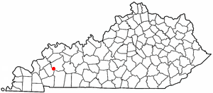
Dawson Springs, Kentucky — City — Location of Dawson Springs, Kentucky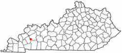
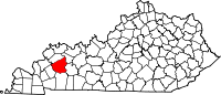
Coordinates: 37°10′18″N 87°41′21″W / 37.17167°N 87.68917°WCoordinates: 37°10′18″N 87°41′21″W / 37.17167°N 87.68917°W Country United States State Kentucky Counties Caldwell, Hopkins[1] Area – Total 4.0 sq mi (10.2 km2) – Land 3.9 sq mi (10.2 km2) – Water 0.0 sq mi (0.0 km2) Elevation 420 ft (128 m) Population (2000) – Total 2,980 – Density 755.8/sq mi (291.8/km2) Time zone Central (CST) (UTC-6) – Summer (DST) CDT (UTC-5) ZIP code 42408 Area code(s) 270 FIPS code 21-20224 GNIS feature ID 0490696 Dawson Springs is a city in Caldwell and Hopkins counties in the Commonwealth of Kentucky. The population was 2,980 at the 2000 census. It is the birthplace of current governor of Kentucky, Steve L. Beshear. From the late 1800s to the 1930s, Dawson Springs was well known as a spa and resort town. It is still popular as a tourist destination because of the Pennyrile Forest State Resort Park and nearby lakes. There is a large and prominent presence of the Ku Klux Klan in Dawson Springs, including the headquarters of the Imperial Klans of America.
Contents
Geography
Dawson Springs is located at 37°10′18″N 87°41′21″W / 37.17167°N 87.68917°W (37.171799, -87.689190)[2].
According to the United States Census Bureau, the city has a total area of 4.0 square miles (10.2 km²), of which 3.9 square miles (10.2 km²) is land and 0.25% is water.
Demographics
As of the census[3] of 2000, there were 2,980 people, 1,214 households, and 801 families residing in the city. The population density was 755.8 people per square mile (292.0/km²). There were 1,353 housing units at an average density of 343.2 per square mile (132.6/km²). The racial makeup of the city was 97.72% White, 0.94% African American, 0.27% Native American, 0.30% Asian, 0.07% from other races, and 0.70% from two or more races. Hispanic or Latino of any race were 0.27% of the population. There were 1,214 households, of which 28.9% had children under the age of 18 living with them, 48.4% were married couples living together, 14.8% had a female householder with no husband present, and 34.0% were non-families. 31.2% of all households were made up of individuals and 17.1% had someone living alone who was 65 years of age or older. The average household size was 2.31 and the average family size was 2.90.
In the city, the population was spread out with 23.1% under the age of 18, 8.4% from 18 to 24, 25.4% from 25 to 44, 21.1% from 45 to 64, and 22.0% who were 65 years of age or older. The median age was 40 years. For every 100 females there were 84.3 males. For every 100 females age 18 and over, there were 78.7 males.
The median income for a household in the city was $22,670, and the median income for a family was $27,872. Males had a median income of $29,545versus $18,875 for females. The per capita income for the city was $14,649. About 25.5% of families and 27.1% of the population were below the poverty line, including 39.0% of those under age 18 and 18.9% of those age 65 or over.
Notable natives
- Dottie Rambo, gospel music artist
- Mila Mason, country music artist
- Steve Beshear, Governor of Kentucky
- Richard Ford, lead singer of christian rock group "Pillar of Fire"
Sports teams
- Baseball: Tradewater Pirates, playing in Riverside Park
References
- ^ "Subcounty population estimates: Kentucky 2000-2008" (CSV). United States Census Bureau, Population Division. 2009-03-18. http://www.census.gov/popest/cities/files/SUB-EST2007-21.csv. Retrieved 2009-04-04.
- ^ "US Gazetteer files: 2010, 2000, and 1990". United States Census Bureau. 2011-02-12. http://www.census.gov/geo/www/gazetteer/gazette.html. Retrieved 2011-04-23.
- ^ "American FactFinder". United States Census Bureau. http://factfinder.census.gov. Retrieved 2008-01-31.
External links
Municipalities and communities of Caldwell County, Kentucky Cities 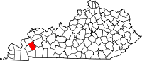
Footnotes ‡This populated place also has portions in an adjacent county or counties
Municipalities and communities of Hopkins County, Kentucky Cities Dawson Springs‡ | Earlington | Hanson | Madisonville | Mortons Gap | Nebo | Nortonville | St. Charles | White Plains
Unincorporated
communitiesFootnotes ‡This populated place also has portions in an adjacent county or counties
Categories:- Cities in Kentucky
- Populated places in Hopkins County, Kentucky
- Populated places in Caldwell County, Kentucky


Wikimedia Foundation. 2010.