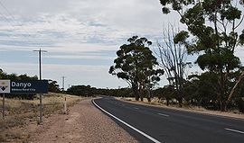
- Danyo, Victoria
-
Danyo
Victoria
Entering DanyoPostcode: 3512 Coordinates: 35°15′30″S 141°17′27″E / 35.25833°S 141.29083°ECoordinates: 35°15′30″S 141°17′27″E / 35.25833°S 141.29083°E Elevation: 95 m (312 ft) Location: - 522 km (324 mi) from Melbourne
- 199 km (124 mi) from Mildura
- 14 km (9 mi) from Murrayville
- 12 km (7 mi) from Cowangie [1]
LGA: Rural City of Mildura State District: Mildura Federal Division: Mallee Danyo on the section of the Mallee Highway between Ouyen and the South Australian border. The place by road is situated about 12 kilometres east from Cowangie and 14 kilometres west from Murrayville.
The Post Office opened on 15 July 1912 when a regular mail service was provided by the opening of the railway from Ouyen to Murrayville a month earlier.The office closed in 1975.[2]
References
- ^ Travelmate
- ^ Premier Postal History, Post Office List, https://www.premierpostal.com/cgi-bin/wsProd.sh/Viewpocdwrapper.p?SortBy=VIC&country=, retrieved 2008-04-11
Danyo is a neighbourhood or area located in Murrayville
(Rural City of Mildura)Please see Murrayville, Victoria
for information on Danyo and other
places located in the same area.Categories:- Towns in Victoria (Australia)
- Australian Aboriginal placenames
- Victoria (Australia) geography stubs
Wikimedia Foundation. 2010.


