- Illinois' 3rd congressional district
Infobox U.S. congressional district
state = Illinois
district number = 3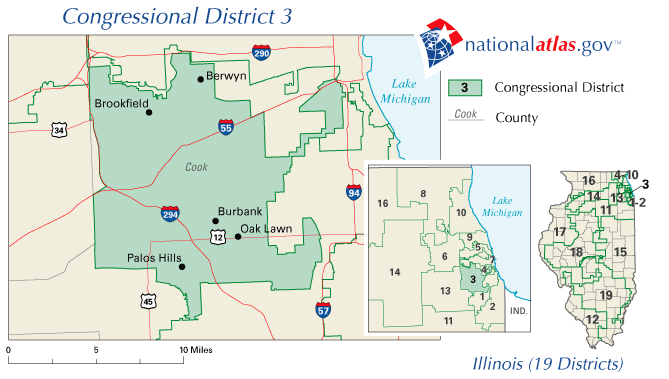
image caption = The 3rd congressional district of Illinois since 2003
representative =Dan Lipinski
party = Democratic
english area = 124.5
metric area = 322.45
percent urban = 100
percent rural = 0
population = 653,647
population year = 2000
median income = 48,048
percent white = 77.9
percent black = 5.9
percent asian = 2.9
percent native american = 0.3
percent hispanic = 21.3
percent other race = 2.7
percent blue collar = 27.6
percent white collar = 58.1
percent gray collar = 14.3
cpvi = D + 10The 3rd Congressional District ofIllinois includes part of Cook County, and has been represented by DemocratDan Lipinski since January 2005; the district was previously represented by his fatherBill Lipinski beginning in 1993. This district includes west and southwest suburbs ofChicago as far as the DuPage County border, as well as a portion of the southwest side of the city of Chicago itself, and covers 124.5square mile s (322.45 km²), making it one of the 50 smallest districts in the U.S., although there are five smaller districts in Illinois. It is adjacent to the 1st District to the east and south, the 4th District to the north, and the 13th District to the west, and also borders the 6th and 7th Districts at its northwest and northeast corners respectively. The district was created following the 1830 Census and came into being in 1833, five months before Chicago was organized as a town; it initially included northern and western Illinoiscite book |last=Parsons |first=Stanley B. |coauthors=William W. Beach, Dan Hermann |title=United States Congressional Districts 1788-1841 |year=1978 |publisher=Greenwood Press |location=Westport, CT |isbn=0-8371-9828-3 |pages=pp. 302-304 ] before representing areas of east central andnorthwestern Illinois from 1843 to 1873.cite book |last=Parsons |first=Stanley B. |coauthors=William W. Beach, Michael J. Dubin |title=United States Congressional Districts and Data, 1843-1883 |year=1986 |publisher=Greenwood Press |location=Westport, CT |isbn=0-313-22045-X |pages=pp. 7-8 ] Parsons, et al. (1986), pp. 53-54.] Parsons, et al. (1986), pp. 102-103.] The district has included part of Chicago since 1873, and part of the city's southwest side since 1895; the district has been primarily suburban since 1973.Although the district has elected Democrats to Congress in 24 of the last 25 elections, and has voted for the Democratic nominee in the last four presidential races, there is also a strong tradition of
social conservatism in the area which has resulted in the election ofconservative Democrat s, as well as greater support for Republicans than might be expected based on voter identification by party.Fact|date=October 2007Geography
The 3rd District includes the municipalities of Bedford Park, Bridgeview, Burbank, Chicago Ridge, Countryside, Forest View, Hickory Hills, Hodgkins, Hometown, Indian Head Park, Justice, La Grange, La Grange Park, Lyons, McCook, Merrionette Park, Oak Lawn, Palos Hills, Riverside, Stickney, Summit and Western Springs, nearly all of Berwyn, Brookfield and Willow Springs, and parts of Alsip, Burr Ridge, Cicero, Forest Park, Hillside, North Riverside, Palos Heights, Palos Park, Westchester and Worth.
In the City of
Chicago , it includes the communities of Bridgeport (home of mayorRichard M. Daley until he relocated in the late 1990s to the Near South Side's Central Station development), Clearing, Garfield Ridge, Mount Greenwood and West Lawn; almost all of Beverly; those portions of Archer Heights and West Elsdon west of Pulaski Road; the western portions of Ashburn, Chicago Lawn and Morgan Park; the portion of McKinley Park south of Archer Avenue; parts of Gage Park and New City; and a small section (1/16 m²) of Armour Square.Demographics
The 3rd District, situated between the Hispanic-majority 4th District to the north and the black-majority 1st and 7th Districts to the east, is the home of numerous sizable and historic ethnic groups including Irish, Polish, German, Italian and Czech immigrants and their descendants. At 14.2%, the Irish make up the largest ethnic group in the district,cite book |last=Tarr |first=David R. (ed.) |title=Congressional Districts in the 2000s: A Portrait of America |year=2003 |publisher=CQ Press |location=Washington, D.C. |isbn=1-56802-849-0 |pages=p. 301 ] cite book |last=Barone |first=Michael |authorlink=Michael Barone (pundit) |coauthors=Richard E. Cohen, Charles E. Cook, Jr. |title=The Almanac of American Politics 2002 |edition= |year=2001 |publisher=National Journal Group |location=Washington, D.C. |isbn=0-8923-4099-1 |pages=pp. 511-513 ] most prominently in the Bridgeport area (the ancestral neighborhood of the
Daley family and other Chicago Irish politicians) and the Mount Greenwood-Beverly area; it is the largest Irish population in any district west ofPhiladelphia 's suburbs.Based on district ethnic demographics in "Congressional Districts in the 2000s: A Portrait of America".] The Polish form the next largest white ethnic group at 13.5%, tying the northwest side's 5th District for the second highest percentage of any district, behind onlyNew York's 27th congressional district . The next largest ethnic groups are Germans (11.0%) and Italians (6.9%). Of the suburbs primarily south of 87th Street (in Palos and Worth Townships), 9 of 10 have larger Irish than Polish populations, usually by large margins; but north of 87th Street, in those areas in Lyons Township south ofInterstate 55 or in the townships to the east of Harlem Avenue, 9 of 10 suburbs have greater Polish populations than Irish, again by large margins. In Oak Lawn, the district's largest suburb, Irish outnumber Polish 30%-19%; in neighboring Burbank, the district's third largest suburb, Polish outnumber Irish by an identical margin.More recently a large Mexican community has moved to the district, notably in Berwyn, Cicero, Hodgkins and Summit where they represent over 30% of the population, and along Archer Avenue, a major Chicago artery that runs through the district's northern section. There is also a sizable Greek community in Oak Lawn and Palos Hills. In the last two decades, there has been notable Arab settlement in the vicinity of Bridgeview, and by the 2000 Census, Arabs represented one of the five largest non-Hispanic ethnic groups in Bridgeview and three adjacent suburbs. Approximately 41% of the district's residents live in Chicago. 21% of the district's population is Hispanic, with 68% white (non-Hispanic), 6%
African American and 3% of Asian descent; redistricting following the 2000 Census and the continued influx of Hispanics tripled the minority population from a decade earlier, as the district in its previous configuration had a population that was 7% Hispanic, 2% African American and 1% Asian.cite book |last=Barone |first=Michael |coauthors=Grant Ujifusa, Richard E. Cohen |title=The Almanac of American Politics 1998 |year=1997 |publisher=National Journal Group |location=Washington, D.C. |isbn=0-89234-081-9 |pages=p. 480 ] The more affluent areas of the district are generally located in its northwestern portion.Economy
The district is a historic U.S. transportation and
shipping hub; not only does it includeChicago Midway International Airport , but it is also traversed by theChicago Sanitary and Ship Canal , the Calumet Sag Channel, and theDes Plaines River , earning national designations for theChicago Portage National Historic Site in Forest View and theIllinois and Michigan Canal National Heritage Corridor. The path of historic Route 66 runs southwest through the district from its eastern end in Chicago.Interstate 55 intersects with both theTri-State Tollway (Interstate 294 ) and theDan Ryan Expressway (Interstate 90 /94) in the district, and in 2001 – since which time the district has shifted slightly to the northwest – it was noted as likely having more freight yards and railroad crossings than any other district.The district includes Toyota Park, home of the Chicago Fire team in
Major League Soccer and theChicago Machine team inMajor League Lacrosse , as well asHawthorne Race Course ; the area also benefits fromChicago White Sox home games atU.S. Cellular Field , which is less than 1000 feet beyond the district's border. Portions of theCook County Forest Preserves cover several square miles in the district's southwest corner. Cultural attractions includeBrookfield Zoo and theBalzekas Museum of Lithuanian Culture in West Lawn; educational institutions includeSt. Xavier University in Mount Greenwood,Moraine Valley Community College in Palos Hills,Morton College in Cicero, andRichard J. Daley College , a Chicago city college, in West Lawn; and medical facilities includeAdvocate Christ Medical Center in Oak Lawn,Adventist La Grange Memorial Hospital in La Grange andMacNeal Hospital in Berwyn. A Ronald McDonald House adjacent to Advocate Christ is scheduled to open in summer 2008. [cite web |url=http://www.rmhccni.org/content.cfm/rmh_hopehospital |title=Ronald McDonald House near Hope Children's Hospital |accessdate=2008-05-24 |publisher=Ronald McDonald House Charities of Chicagoland and Northwest Indiana ] Industrial and business presences in the district include: Tootsie Roll Industries;Electro-Motive Diesel ; aNabisco bakery which is the largest biscuit bakery in the world [https://www.kraftoperations.com/Facility.asp?FacilityID=93] ; the Chicago Area Consolidation Hub ofUnited Parcel Service and adjacentBNSF Railway yard [http://www.trains.com/trn/default.aspx?c=a&id=549] ; an ACH Food manufacturing plant (formerly part of Corn Products Company) in Summit [http://www.achfood.com/careers.aspx?type=sum] ; anOwens Corning roofing and asphalt plant in Summit; and a Nalco Chemical plant in Bedford Park. The former site of theInternational Amphitheatre , now an Aramark plant, is within the district. Organizations based in the district include theAmerican Nuclear Society in La Grange Park. Among the federal facilities in the district is the Great Lakes Regional Headquarters of theNational Archives and Records Administration [http://www.archives.gov/great-lakes/chicago/] in West Lawn.Other district sites on the
National Register of Historic Places include:
*American State Bank, Berwyn
*Berwyn Health Center
*Berwyn Municipal Building
*Avery Coonley House , Riverside
*Cornell Square , New City, Chicago
*Arthur J. Dunham House , Berwyn
*First Congregational Church of Western Springs
*Grossdale Station , Brookfield
*Haymarket Martyrs' Monument National Historic Landmark, Forest Park
*Hofmann Tower , Lyons
*La Grange Village Historic District
*Lyons Township Hall , La Grange
*Oak Lawn School , Oak Lawn
*Old Stone Gate of Chicago Union Stockyards National Historic Landmark, New City, Chicago
*George E. Purple House , La Grange
*Ridge Historic District , Beverly/Morgan Park, Chicago
*Riverside Landscape Architecture District , Riverside
*Robert Silhan House , Berwyn
*F.F. Tomek House , Riverside
*Western Springs Water Tower Politics
The 3rd District has been described as "ancestrally Democratic, culturally conservative, multiethnic and viscerally patriotic."cite book |last=Barone |first=Michael |coauthors=Richard E. Cohen |title=The Almanac of American Politics 2006 |year=2005 |publisher=National Journal Group |location=Washington, D.C. |isbn=0-89234-111-4 |pages=p. 567 ] It earned a reputation as being home to
Reagan Democrat s when in the 1980 presidential election it was one of only two Chicago districts (out of nine) to be won by RepublicanRonald Reagan , along with the 6th District (an almost entirely suburban district which also included Chicago's O'Hare Airport); the district simultaneously reelected Democratic congressmanMarty Russo with nearly 69% of the vote. [cite book |title=Guide to U.S. Elections |edition=5th edition |year=2005 |publisher=CQ Press |location=Washington, D.C. |isbn=1-56802-981-0 |pages=p. 1217 ] The Reagan Democrat description became even more appropriate when Reagan received 65% of the vote here in 1984, as Russo again won with 64%. ["Guide to U.S. Elections", p. 1227.] Redistricting for the 1990s shifted the district into more reliably Democratic territory, butBill Clinton won the district in 1992 by just a 41%-39% margin despite receiving at least 65% of the vote in four other south side districts; he won the district with 53% in 1996 although his totals in the other south side districts were all between 80-85%.George W. Bush received 41% of the vote here in both 2000 and 2004 despite not exceeding 21% in any of the other four south side districts; it was his best performance in any district located primarily within Cook County. Much of the district's current suburban territory was in the 4th District from the 1950s to the 1970s, when that was a solidly Republican suburban district represented byEd Derwinski ; more recently, Lyons, Palos and Riverside Townships, which together approximately correspond with the district's western half, all voted for Bush in 2000. ["Congressional Districts in the 2000s: A Portrait of America", p. 300.] Over the last eight presidential elections, the Democratic nominee for Congress has run an average of 20 points ahead of the party's nominee for president in the district. [Based on results from 1976 through 2004 in the "Guide to U.S. Elections".]Redistricting which took effect for the 1992 elections kept only 40% of the district's previous area, and pitted nine-term incumbent Russo – who changed his residence rather than run in the 2nd District, which now included his previous home – against five-term incumbent
Bill Lipinski , who had previously represented the 5th District, in the Democratic primary. Lipinski ran close to Russo in the suburbs but easily won the Chicago areas, and won the primary 58%-37%. [cite book |last=Barone |first=Michael |coauthors=Grant Ujifusa |title=The Almanac of American Politics 1994 |year=1993 |publisher=National Journal Group |location=Washington, D.C. |isbn=0-89234-057-6 |pages=p. 395 ] Lipinski was decidedly the most conservative Democrat in the Illinois delegation, opposing abortion and gays in the military, supportingschool prayer , tuition vouchers, theDefense of Marriage Act and the death penalty, and helping to write a proposed constitutional amendment in 1997 prohibiting flag desecration.cite book |last=Barone |first=Michael |coauthors=Richard E. Cohen |title=The Almanac of American Politics 2004 |year=2003 |publisher=National Journal Group |location=Washington, D.C. |isbn=0-89234-105-X |pages=p. 542 ] cite book |last=Nutting |first=Brian |coauthors=H. Amy Stern (eds.) |title=Congressional Quarterly's Politics in America 2002 |year=2002 |publisher=Congressional Quarterly |location=Washington, D.C. |isbn=1-56802-655-2 |pages=pp. 312-313 ] A member of theBlue Dog Democrat s, he was one of just 30 Democrats to vote for the Republicanwelfare reform plan. He clashed often with the Clinton administration, opposing the president's position over half the time in the 1997-98 Congress.cite book |last=Sharp |first=J. Michael |title=Directory of Congressional Voting Scores and Interest Group Ratings |year=2006 |publisher=CQ Press |location=Washington, D.C. |isbn=1-56802-970-5 |pages=p. 941 ] He was one of 31 Democrats to vote in favor of a Judiciary Committee inquiry during the leadup to Clinton's impeachment; he eventually voted against impeachment, but simultaneously called on Clinton to resign.Barone, et al. (2001), p. 512.] In 1999, Lipinski stated that Clinton "doesn't have credibility on military issues," adding that "the American people feel Clinton is unsure." He was a consistent opponent of U.S. free trade agreements, arguing that they were disastrous for American manufacturing. Lipinski received higher approval ratings from theAmerican Conservative Union than from the ACLU in 12 of his last 13 years in office, though his highest ratings generally came from labor and consumer groups and the Christian Coalition.cite web |url=http://www.issues2002.org/IL/William_Lipinski_HouseMatch.htm |title=William Lipinski on VoteMatch |accessdate=2007-03-27 ] He received a 0 rating from the ACLU for the 1997-98 term, and also compiled an overall 0 rating from theNational Abortion Rights Action League . His policies enabled him to work easily with Republicans; he was a candidate to become Transportation Secretary in the Bush administration, and collaborated with House SpeakerDennis Hastert of the 14th District to design the state's redistricting plan following the 2000 Census. Lipinski's positions were generally in line with those of district residents, [Barone, et al. (2001), p. 512.] and after surviving with a 54%-46% win amid the Republican gains of 1994 he was reelected by increasing margins in each succeeding election; in 2002 he became the first unopposed candidate in the history of the 3rd District. [Based on results from 1832 through 2002 in the "Guide to U.S. Elections".]The district's seat changed hands under somewhat controversial circumstances in 2004. Lipinski was renominated in the primary election, but in August announced his intention to withdraw from the race, just two weeks before the deadline for replacing a candidate on the ballot. Four days later, the district's ward and township committeemen – including Lipinski himself as well as Mayor Daley's brother John and Illinois House Speaker
Michael Madigan – met to choose a replacement; Lipinski nominated his son Dan, an assistant professor at theUniversity of Tennessee , and he was approved without opposition despite not having lived in Illinois since 1989. In his initial campaign, the younger Lipinski stated that his policies made him "not really that different from" his father, and indicated that he would oppose same-sex marriage as well as abortion except when the mother's life was at stake. True to the district's heritage, he identified Reagan as his political hero. [Barone, et al. (2005), pp. 567-568.]Since taking office, Dan Lipinski has continued his father's pro-life stance, voting with Republicans to give federal courts jurisdiction in the Terri Schiavo case, and to maintain restrictions on federal funding for embryonic stem cell research.cite web |url=http://projects.washingtonpost.com/congress/members/l000563/key-votes/ |title=Key Votes by Daniel Lipinski |accessdate=2007-04-18 |publisher=The Washington Post ] Among the legislation he has sponsored is the Family and Consumer Choice Act (HR 2738 IH), which would require cable television companies to either provide subscribers with increased options of channel selection or comply with the same FCC decency standards that apply to broadcasters. [cite web |url=http://news.yahoo.com/s/nm/20070614/tv_nm/indecency_congress_dc_4 |title=House bill aims to curb indecent TV programs |accessdate=2007-06-21 |last=Younglai |first=Rachelle |publisher=Reuters |date=
2007-06-14 ] He has voted to strengthen border security, with no provisions for citizenship for illegal immigrants, and to build a 700-mile fence along the Mexican border. In December 2005 he voted to make the Patriot Act permanent. In June 2006 he joined Republicans in opposing a timetable for troop withdrawal from Iraq and declaring the Iraq War to be a part of theWar on Terrorism . Although in March 2007 he voted with Democrats in supporting a war spending bill which would establish a timetable, in May he voted for a spending bill which favored benchmarks rather than a timetable. [cite web |url=http://www.ontheissues.org/IL/Dan_Lipinski.htm |title=Dan Lipinski on the Issues |accessdate=2007-04-18 ]Representation
History of district boundaries
The total number of representatives allotted to Illinois during each period follows the years in parentheses; boundaries went into effect beginning with the previous year's elections:
*1833-1843 (3): The district included the bulk of northern and western Illinois: Adams, Calhoun, Cook, Fulton, Greene, Hancock, Henry, Jo Daviess, Knox, LaSalle, Macon, McDonough, McLean, Mercer, Morgan, Peoria, Pike, Putnam, Sangamon, Schuyler, Tazewell and Warren counties (numerous additional counties were later created within this area). During this period,
Abraham Lincoln was a district resident, beginning his political career as a state legislator; the district's representative from 1839 to 1843 was Lincoln's law partner,John T. Stuart .
*1843-1853 (7): The district was shifted to the east central part of the state, taking in Christian, Clark, Clay, Coles, Crawford, Cumberland, DeWitt, Edgar, Effingham, Fayette, Jasper, Lawrence, Macon, Moultrie, Piatt, Richland and Shelby counties.
*1853-1863 (9): The district was shifted north to cover the twelve counties to the south and southwest of Cook County: Bureau, Champaign, DeWitt, Grundy, Iroquois, Kendall, LaSalle, Livingston, McLean, Putnam, Vermilion and Will counties.
*1863-1873 (14, including one elected at large): The district was relocated to include the six counties in the northwestern corner of the state: Carroll, Jo Daviess, Lee, Ogle, Stephenson and Whiteside counties.
*1873-1883 (19): The district was again relocated, and now included Lake County, the sixteen townships comprising the northern half of Cook County (Barrington, Cicero, Elk Grove, Evanston, Hanover, Jefferson, Lake View, Leyden, Maine, New Trier, Niles, Northfield, Palatine, Proviso, Schaumburg, Wheeling), and the north side of Chicago (the city's northern boundary east of the river was then Fullerton Avenue). [Parsons, et al. (1986), pp. 159-160.] During this period, the Near North Side was recovering from the devastation of theGreat Chicago Fire of October 1871.
*1883-1895 (20/22): The district included those parts of the west side between 12th Street (nowRoosevelt Road ) and the North Branch of theChicago River , excluding a small area north of 12th Street near the river; as the city was still expanding westward, the western boundary was Western Avenue from the river to North Avenue, and Crawford Avenue (now Pulaski Road) from North to 12th.cite book |last=Parsons |first=Stanley B. |coauthors=Michael J. Dubin, Karen Toombs Parsons |title=United States Congressional Districts, 1883-1913 |year=1990 |publisher=Greenwood Press |location=Westport, CT |isbn=0-313-26482-1 |pages=pp. 23-27 ] Illinois gained two additional representatives following the 1890 Census, but they were elected on an at-large basis for the 1893-1895 term before redistricting occurred, and the previous decade's districting remained in effect. [Parsons, et al. (1990), pp. 182-186.]
*1895-1903 (22): The district now included the area from the river south to 26th Street; the area west of the river and south of 12th Street bordered on the west by Johnson Street (now Peoria Street) from 12th to 22nd Street (nowCermak Road ) and byHalsted Street from 22nd to the river; and the area south of theIllinois and Michigan Canal and the river as far south as 39th Street (now Pershing Road) between Western and Wentworth Avenues. [Parsons, et al. (1990), pp. 187-191.] In the 1896 House election,Clarence Darrow lost by 590 votes (2.5%). ["Guide to U.S. Elections", p. 1005.]
*1903-1949 (initially 25; two of 27 elected at large from 1913-43, and one of 26 elected at large from 1943-49): The district began to take on its modern territory, and included the nine southernmost townships of Cook County (Bloom, Bremen, Calumet, Lemont, Orland, Palos, Rich, Thornton and Worth), as well as that part of Chicago west of State Street between 51st Street and 111th Street excepting one and a quarter square miles in the southeast corner. (Note: In 1903 the city's western limit at 111th Street was Western Avenue, and at 115th Street was Ashland Avenue; but during this period, various portions of Calumet and Worth townships were annexed by Chicago.) [Parsons, et al. (1990), pp. 326-330.] Illinois' districts were not redrawn until 1947, taking effect for the 1948 elections. [cite book |last=Barrett |first=Edward A. (ed.) |title=Blue Book of the State of Illinois, 1947-1948 |publisher=State of Illinois |location=Springfield, IL |pages=p. 110 ]
*1949-1963 (26 from 1949-1953; 25 thereafter): The district included that part of Chicago bounded on the north by 65th Street (Cicero Avenue to Western Avenue), Marquette Road (Western to Damen), 59th Street (Damen to Wallace) and Garfield Boulevard (Wallace to the railroad between Wentworth and State Street), and bounded on the east by the railroad (Garfield to 59th), State Street (59th to 73rd Street), Indiana Avenue (73rd to 83rd Street), South Park Boulevard (later renamed King Drive, 83rd to 99th Street), Stewart Avenue (99th to 103rd Street) and Halsted (103rd to 123rd Street). [Barrett, pp. 113-114.] The same boundaries were maintained in the redistricting after 1950. [cite book |title=Congressional District Atlas of the United States |year=1960 |publisher=U.S. Bureau of the Census |location=Washington, D.C. |pages=pp. 18-20 ]
*1963-1973 (24): Shifting slightly, the district included the village of Evergreen Park as well as that part of Chicago bounded on the north by 66th Street (Cicero to the railroad 1/2 mile east of Kedzie), Marquette (the railroad to Damen), 59th Street (Damen to Racine) and Garfield (Racine to the railroad 1/4 mile east of Halsted), and bounded on the east by the railroad (Garfield to 59th), Halsted (59th to 63rd Street), State Street (63rd to 83rd Street), Stewart (83rd to 99th Street), State Street (99th to 111th Street), Wentworth Avenue (111th to 113th Street) and Halsted (113th to 123rd Street). [cite book |title=Congressional District Data Book: Districts of the 88th Congress |year=1963 |publisher=U.S. Bureau of the Census |location=Washington, D.C. |pages=pp. 125-127 ] There was additional redistricting in Illinois which took effect for the 1967-1969 term, but the 3rd District was not altered. [cite book |title=Congressional District Data Book, Illinois supplement |year=1966 |publisher=U.S. Bureau of the Census |location=Washington, D.C. |pages=pp. 2-4 ]
*1973-1983 (24): The district shifted primarily into suburban areas to include Thornton and Calumet Townships, most of Worth Township (excepting the municipalities of Bridgeview, Chicago Ridge, Crestwood, Palos Heights and Worth), the Chicago communities of Ashburn and Mount Greenwood, those parts of West Lawn and Chicago Lawn south of 63rd Street, and those parts of Beverly and Morgan Park west of Western Avenue. [cite book |title=Congressional District Data Book: 93rd Congress |year=1973 |publisher=U.S. Bureau of the Census |location=Washington, D.C. |pages=pp. 145, 147-148 ]
*1983-1993 (22): Parts of the district shifted to the west. The district now included: Bremen Township; Worth Township excepting that part between 111th Street and 135th Street west of Cicero Avenue as well as approximately 1/4 mi² of Worth north of 111th; that part of Calumet Township in Blue Island and Calumet Park northwest of the railroad running from 123rd and Laflin to the western township line; that part of Thornton Township west of the Calumet Expressway having as its northern boundary 167th Street (from the Bremen Township line to the eastern edge of Hazel Crest), 171st/172nd Street (Hazel Crest to Halsted Street), 167th (Halsted to State Street, which becomes Indiana Avenue) and the Little Calumet River (Indiana Avenue to the Calumet Expressway); the part of Stickney Township south of 65th Street; the Chicago communities of Clearing, West Lawn, Ashburn, Mount Greenwood and Beverly, the western part of Morgan Park, and the additional part of Chicago between 55th Street, 75th Street, Cicero Avenue and the railroad 1/4 mile east of Western excepting that portion from the railroad to Western between 63rd Street and 69th Street. [cite book |last=Gottron |first=Martha V. (ed.) |title=Congressional Districts in the 1980s |year=1983 |publisher=Congressional Quarterly |location=Washington, D.C. |isbn=0-87187-264-1 |pages=p. 163 ]
*1993-2003 (20): The district shifted significantly to the northwest, and now included: all of Lyons Township; all of Stickney Township except the portion north of Pershing Road; all of Berwyn and Riverside; approximately the eastern half of Brookfield and the western half of Cicero; those portions of Forest Park and North Riverside east of the Des Plaines River and south of Harrison Street; most of Oak Park south of the Eisenhower Expressway; those parts of Worth Township having as their eastern boundary Pulaski Road from 87th Street to 101st Street, and Cicero Avenue from 101st Street to 135th Street, with minor variations in Oak Lawn; those parts of Palos Township having as their western boundary Roberts Road (80th Avenue) from 87th Street to 120th Street and then southwest along the railroad to 135th Street, plus approximately 1/8 m² west of Roberts Road in the vicinity of Stagg High School; those parts of Bremen Township having as their eastern boundary Cicero Avenue from 135th Street to 143rd Street, the railroad and then Pulaski from 143rd Street to 159th Street, Cicero from 159th Street to 167th Street,Interstate 57 from 167th Street to 177th Street, and Central Avenue from 177th Street to 183rd Street; the Chicago communities of Garfield Ridge, Clearing, Archer Heights, West Elsdon and West Lawn, those parts of Gage Park, Chicago Lawn and Ashburn west of Kedzie Avenue, approximately those parts of Brighton Park northwest of 38th Street and St. Louis Avenue or southwest of 43rd Street and Kedzie, and nearly 1/8 m² in the southwest corner of Austin. [cite book |title=Congressional District Atlas: 103rd Congress of the United States |year=1993 |publisher=U.S. Bureau of the Census |location=Washington, D.C. |isbn=0-16-041689-2 |pages=pp. Illinois-1, 5, 22-26, 28-29, 31-32, 34 ]
*2003-present (19): See map and geography above. For a more detailed map, see the Census Bureau map linked below.Presidential voting
This table indicates how the 3rd District has voted in U.S. presidential elections; election results reflect voting in the district as it was configured at the time of the election, not as it is configured today. The candidate who received the most votes in the district is listed first; the candidate who won the election nationally is in CAPS, and the candidate who won the state of Illinois is indicated with a †.
References
External links
* [http://projects.washingtonpost.com/elections/keyraces/census/il/district-3/ "Washington Post" page on the 3rd District of Illinois]
*PDFlink| [http://www.census.gov/prod/2004pubs/03statab/congdist.pdf Statistical Abstract of the United States: 2003] |163 KiB - Congressional District Profiles, U.S. Census Bureau
*PDFlink| [http://www2.census.gov/geo/maps/cong_dist/cd108_named/ind_pdf/IL_CD03n.pdf U.S. Census Bureau - 3rd District map] |1.26 MiB
* [http://fastfacts.census.gov/servlet/CWSFacts?_event=ChangeGeoContext&geo_id=50000US1703&_geoContext=01000US%7C04000US17%7C50000US1711&_street=&_county=&_cd=50000US1703&_cityTown=&_state=04000US17&_zip=&_lang=en&_sse=on&ActiveGeoDiv=&_useEV=&pctxt=fph&pgsl=500&_content=&_keyword=&_industry= U.S. Census Bureau - 3rd District Fact Sheet]
Wikimedia Foundation. 2010.