- Illinois' 1st congressional district
Infobox U.S. congressional district
state = Illinois
district number = 1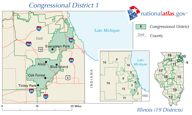
image caption = The 1st congressional district of Illinois since 2003
representative =Bobby Rush
party = Democratic
english area = 97.84
metric area = 253.41
percent urban = 100
percent rural = 0
population = 653,647
population year = 2000
median income = 37,222
percent white = 29.5
percent black = 65.5
percent asian = 1.4
percent native american = 0.2
percent hispanic = 4.8
percent other race = 1.4
percent blue collar = 21.6
percent white collar = 61.3
percent gray collar = 17.1
cpvi = D + 35The 1st Congressional District ofIllinois includes part of Cook County, and has been represented by DemocratBobby Rush since January 1993. This district includes much of the South Side ofChicago , extending into the city's southwest suburbs until reaching the border of Will County, and covers 97.84square mile s (253.41 km²), making it one of the 40 smallest districts in the U.S. although there are four smaller districts in Illinois. It is adjacent to the 2nd District to the east and south, the 7th District to the north, and the 3rd and 13th Districts to the west, and also borders the 11th District at its southwest corner; the district's northeast border followsLake Michigan 's shoreline for almost a mile. The district was created following the 1830 Census and came into being in 1833, five months before Chicago was organized as a town; the state was previously represented in Congress on an at large basis. The 1st District initially included southwestern Illinois until 1853cite book |last=Parsons |first=Stanley B. |coauthors=William W. Beach, Dan Hermann |title=United States Congressional Districts 1788-1841 |year=1978 |publisher=Greenwood Press |location=Westport, CT |isbn=0-8371-9828-3 |pages=pp. 302-304 ] cite book |last=Parsons |first=Stanley B. |coauthors=William W. Beach, Michael J. Dubin |title=United States Congressional Districts and Data, 1843-1883 |year=1986 |publisher=Greenwood Press |location=Westport, CT |isbn=0-313-22045-X |pages=pp. 7-8 ] and the state's northern edge until 1863Parsons, et al. (1986), pp. 53-54.] ; since that time the district has included all or part of Cook County, with its population primarily residing onChicago's South Side since 1883.The district has the highest percentage (65.5) of
African American residents in the nation, and has been represented in Congress by African Americans since 1929. It is also one of the most reliably Democratic districts in the country, although not quite to the nearly monolithic extent that it was during the 1980s when over 90% of the district's residents were black.cite book |last=Gottron |first=Martha V. (ed.) |title=Congressional Districts in the 1980s |year=1983 |publisher=Congressional Quarterly |location=Washington, D.C. |isbn=0-87187-264-1 |pages=p. 156 ] The district has not elected a Republican to Congress since 1932, and Democratic candidates routinely receive over 80% of the vote here.Geography
In the City of
Chicago , the 1st District includes the communities of Auburn Gresham, Burnside, Chatham and Greater Grand Crossing; almost all of West Englewood; the portion of Englewood south of 57th Street; the portion of Woodlawn west ofStony Island Avenue (i.e. excluding Jackson Park); the southern half of Kenwood (home of U.S. SenatorBarack Obama ); the eastern portion of Ashburn; parts of Avalon Park, Calumet Heights, Chicago Lawn, Douglas, Grand Boulevard, Hyde Park, Morgan Park, New City, Oakland, Roseland, South Shore, Washington Heights and Washington Park; the portion of Beverly southeast of 97th Street and Prospect Avenue; the portion of West Pullman southwest of 119th Street and Racine Avenue; and approximately two square blocks at the northwest corner of South Chicago.The district's area south of 95th Street is almost entirely west of the
Dan Ryan Expressway (Interstate 57 ). The district includes the suburban municipalities of Crestwood, Evergreen Park, Midlothian, Posen and Robbins, nearly all of Alsip, Blue Island and Oak Forest, parts of Calumet Park, Dixmoor, Markham, Orland Hills, Orland Park, Palos Heights, Tinley Park and Worth, and some small sections of Country Club Hills and Riverdale.Demographics
Illinois' 1st District was the nation's first district with a black majority population, and has included the central area of Chicago's South Side
African American community since the 1920s. Over 85% of the district's residents were black during the period from the 1950s through the 1980s, but redistricting since that time – which redrew the district lines with the goal of maintaining three Chicago districts with black populations exceeding 60% – has reduced the percentage of black residents in the 1st District to 70% in the 1990s and the current figure of 65%. Outward migration has caused the South Side's population to decrease over the years, and the district has expanded to the southwest to gain residents, particularly as the state's Congressional delegation has been reduced in numbers; the district, which covered only nine square miles in the 1950s, is now over ten times that size, and nearly half its current area was added for the 2000s.The 1st District's population dropped by 27% in the 1950s, [cite book |title=Congressional District Data Book: Districts of the 87th Congress |year=1961 |publisher=U.S. Bureau of the Census |location=Washington, D.C. |pages=p. 16 ] and by 20% in both the 1970s and 1980s, [cite book |title=Congressional Districts in the 1990s: A Portrait of America |year=1993 |publisher=Congressional Quarterly |location=Washington, D.C. |isbn=0-87187-722-8 |pages=p. 235 ] and in redistricting after the 1990 Census, the district was extended into the suburbs for the first time in 90 years. Chicago is now home to 70% of the district's residents (down from 90% in the 1990s), [cite book |last=Tarr |first=David R. (ed.) |title=Congressional Districts in the 2000s: A Portrait of America |year=2003 |publisher=CQ Press |location=Washington, D.C. |isbn=1-56802-849-0 |pages=p. 296 ] although roughly 60% of the district's area is outside the city. The district's white population (almost 30% of its residents) is concentrated in the suburban areas and in a few Chicago neighborhoods such as Hyde Park. [See [http://fastfacts.census.gov/servlet/CWSThematicMapFramesetServlet?_bm=y&-oldGeo=50000US1701&-_MapEvent=displayBy&-tm_name=DEC_2000_110H_M00265&-ds_name=DEC_2000_110H&-ActiveGeoDiv=&-back=/servlet/CWSFacts%3F_event%3DChangeGeoContext%26geo_id%3D50000US1701%26_geoContext%3D01000US%257C04000US17%257C50000US1711%26_street%3D%26_county%3D%26_cd%3D50000US1701%26_cityTown%3D%26_state%3D04000US17%26_zip%3D%26_lang%3Den%26_sse%3Don%26ActiveGeoDiv%3D%26_useEV%3D%26pctxt%3Dfph%26pgsl%3D500%26_content%3D%26_keyword%3D%26_industry%3D&-pgsl=500&-redoLog=false&-geo_id=50000US1701&-_dBy=511&-pctxt=fph U.S. Census Bureau map] showing distribution of district's white population.] The district's largest white ethnic groups are Irish (7.1%), German (6.2%), Polish (4.5%) and Italian (3.2%), ["Congressional Districts in the 2000s: A Portrait of America", p. 298.] mirroring the demographics of the neighboring 3rd and 13th Districts. There are also sizable Dutch, Swedish, Czech, Greek and Lithuanian populations in the area of Oak Forest, Orland Park and Tinley Park, the district's three largest suburbs.
The Kenwood-Hyde Park area was for several decades home to a significant Jewish community, and there is still ample evidence of its history; the former Kehilath Anshe Ma'ariv temple (its second location) has been the headquarters of
Jesse Jackson 's Operation PUSH/Rainbow Coalition since 1971 [http://ecuip.lib.uchicago.edu/diglib/social/cityofneighborhoods/southlakefront/con_tour_f-g.html] . The area also includes a notable Black Muslim presence; the home ofNation of Islam leaderLouis Farrakhan is in Kenwood.As of 2000, only 38% of the district's adult residents were married, well below the national average of 54.4%.
Economy
The departure of the steel industry, along with other manufacturing jobs, from the South Side in recent decades has created economic difficulties which the area is still trying to overcome. The 1st District's median household income as of 2000, $37,222, trailed the national average by 11.4%, the unemployment rate (7.6%) was more than double the national rate, and nearly 20% of district residents were living in poverty. These problems are more pronounced within the Chicago portion of the district – 14 of the district's 18 suburbs had median household incomes over $40,000 as of 1999, with the six most affluent grouped in the southwest corner of the district – although black middle-class Chicago neighborhoods such as Avalon Park and Chatham have remained more stable, along with the more upscale Hyde Park-Kenwood area. Health care and higher education now constitute major economic sectors in the region.
Hospitals in the district include Oak Forest Hospital in Oak Forest and Provident Hospital in Grand Boulevard, both part of the
Cook County Bureau of Health Services , as well as theUniversity of Chicago Hospitals in Hyde Park, Little Company of Mary Hospital in Evergreen Park, Holy Cross Hospital in Chicago Lawn, St. Francis Hospital in Blue Island,Jackson Park Hospital in South Shore andSt. Bernard Hospital in Englewood.Local educational institutions include the
University of Chicago in Hyde Park,Illinois Institute of Technology (IIT) in Douglas,Trinity Christian College in Palos Heights andKennedy-King College , a Chicago city college, in Englewood, andChicago State University in Roseland is located directly outside the district at its southern edge; in addition, there are five seminaries in Hyde Park: theCatholic Theological Union ,Chicago Theological Seminary , Lutheran School of Theology,McCormick Theological Seminary andMeadville Lombard Theological School .U.S. Cellular Field , home of theChicago White Sox , is less than 1000 feet west of the district's northwestern border. Other area cultural and entertainment attractions include the DuSable Museum of African American History in Chicago's Washington Park, andFirst Midwest Bank Amphitheatre in Tinley Park; several square miles ofCook County Forest Preserves can be found on three sides of Oak Forest, and Oak Forest's Chicago Gaelic Park [http://www.chicagogaelicpark.org/] is home to Irish Fest, held annually on Memorial Day weekend. Business and industrial presences in the district include Panduit Corporation [http://www.panduit.com/] , an electrical manufacturer in Tinley Park; Parco Foods [http://www.parcofoods.com/] , a cookie manufacturer in Blue Island; and Midwest Suburban Publishing, publisher of the "Daily Southtown ", in Tinley Park.In addition to Washington Park and those sites associated with the University of Chicago and IIT, district locations on the
National Register of Historic Places include:References
External links
* [http://projects.washingtonpost.com/elections/keyraces/census/il/district-1/ "Washington Post" page on the 1st District of Illinois]
*PDFlink| [http://www.census.gov/prod/2004pubs/03statab/congdist.pdf Statistical Abstract of the United States: 2003] |163 KiB - Congressional District Profiles, U.S. Census Bureau
*PDFlink| [http://www2.census.gov/geo/maps/cong_dist/cd108_named/ind_pdf/IL_CD01n.pdf U.S. Census Bureau - 1st District map] |1.47 MiB
* [http://fastfacts.census.gov/servlet/CWSFacts?_event=ChangeGeoContext&geo_id=50000US1701&_geoContext=01000US%7C04000US17%7C50000US1711&_street=&_county=&_cd=50000US1701&_cityTown=&_state=04000US17&_zip=&_lang=en&_sse=on&ActiveGeoDiv=&_useEV=&pctxt=fph&pgsl=500&_content=&_keyword=&_industry= U.S. Census Bureau - 1st District Fact Sheet]
Wikimedia Foundation. 2010.