- Marakkanam
-
Marakkanam — city — Coordinates 12°12′N 79°57′E / 12.2°N 79.95°ECoordinates: 12°12′N 79°57′E / 12.2°N 79.95°E Country India State Tamil Nadu District(s) Viluppuram Population 19,153 (2001[update]) Time zone IST (UTC+05:30) Area
• 14 metres (46 ft)
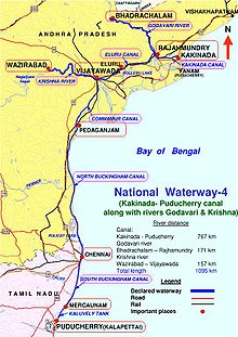
Marakkanam(Tamil:மரக்காணம்) is a Coastal panchayat town (பேரூராட்சி) in Viluppuram district in the Indian state of Tamil Nadu.It is well connected to the State Capital Chennai & nearby State Pondicherry by East Coast Road (ECR). In the West side, Marakkanam is connected to taluk head quarter town Tindivanam by State Highway SH-134.Marakkanam is situated on the declared National Waterways NW-4. On materialisation of National Waterways NW-4, Marakkanam will be connected to two states Andhra Pradesh (Kakinada) & Pondicherry through North and South Buckingham Canal.
Contents
History
Marakkanam was connected to Vijayawada in Andhra Pradesh through the Buckingham Canal ,a 420 km long fresh water navigation canal. The 110 k.m Stretch from Marakkanam to Chennai is called South Buckingham Canal. The canal connects most of the natural backwaters along the coast to the port of Chennai (Madras). It was constructed by the British Raj, and was an important waterway during the late nineteenth and the twentieth century.Canal was formerly used to convey goods up and down, but later the usage has downgraded due to industrial pollution of water.
India's National Waterways NW-4 Connecting Kakinada (Andhra Pradesh) & Puducherry. NW-4 passes through Rajamundry, Vijayawada, Pedakanjam, Chennai, Marakkanam & Pondicherry
Geography
Indian Postal code for Marakkanam is 604303.
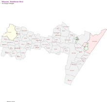
Marakkanam panchayat town was divided into 56 Village Panchayats.The following are the Village Panchayats under Marakkanam
- Adasal
- Adavallikoothan
- Alankuppam
- Alapakkam
- Alathur
- Annamputhur
- Anumandai
- Asappur
- Athur
- Brammadesam
- Chettikuppam
- Cheyyankuppam
- Endiyur
- Endur
- Eraiyanur
- Jaggampettai
- Kandadu
- Kattalai
- kaippani nagar
- Kilarungunam
- Kiledaiyalam
- Kilpettai
- Kilputhuppattu
- Kilsithamur
- Kilsiviri
- Kolathur
- Koonimedu
- Kovadi
- Kurur
- Manur
- Molasur
- Munnur
- Nadukuppam
- K.N Palayam
- pudhuppakkam
- Kandadu
- Nagalpakkam
- Nagar
- Nallalam.t
- Nallur
- Nalmukkal
- mandur
- Omippair
- Panichamedu
- Perumukkal
- Pudhupakkam.m
- Salavadi
- Singanur
- Thenkalavaii
- Thennerkunam
- Thenpasar
- Urani
- Vada Nerkunam
- Vadaalappakkam
- Vadakottippakkam
- Vaidappakkam
- Vannippair
- Vengai
- Vittalapuram
- Siruvadi
Demographics
As of 2001[update] India census[1], Marakkanam had a population of 19,153. Males constitute 50% of the population and females 50%. Marakkanam has an average literacy rate of 61%, higher than the national average of 59.5%: male literacy is 70%, and female literacy is 52%. In Marakkanam, 13% of the population is under 6 years of age.
Major resources
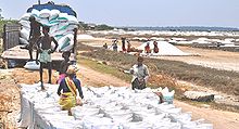
Salt Production
Fishing
Agriculture
Real Estate
TEMPLES
- BUMIEASWARER
Churchs
- Lord Jesus Christ's Prayer House (kolathur)
- Our Lady of Maduranayaguy Church (Roman Catholic)
Schools
- Government Higher Secondary School
- Government Girls High School
- Panchayat Union Elementary School
- J.M.J. Matriculation School
- Ramakrishna Matriculation School
Hospitals
Government Hospital, Marakkanam (Near ECR bypass)
Road Connectivity
- 35 km from Tindivanam. It's Well connected to the taluk head quarter town Tindivanam.
- All the Buses plying through ECR via Kovalam, Mamallapuram, Kadapakkam Chennai to Puduchery are connected to Marakkanam.
- Connected to Chennai & Puducherry with Govt Bus No 83A via Chengalpattu, Madhuranthagam, Soonambedu, Allathur
- Connected to Chennai & Marakkanam with Govt Bus No 188A via Kovalam, Mamallapuram, Kalpakkam, Kadapakkam
- Connected to Chennai & Cuddalorewith Govt Bus No 162 via Chengalpattu, Madhuranthagam, Soonambedu, Allathur
Places near Marakkanam
- Tindivanam
- Kalpakkam
- Puducherry
- Koonimedu
- Murukkery
- Brahmadesam
- Nagar-5 km from Murukkery towards North
- Nallalam
- Soonambedu
- Kadapakkam
- Alamparai Fort
- Vadanerkunam
References
- ^ "Census of India 2001: Data from the 2001 Census, including cities, villages and towns (Provisional)". Census Commission of India. Archived from the original on 2004-06-16. http://web.archive.org/web/20040616075334/http://www.censusindia.net/results/town.php?stad=A&state5=999. Retrieved 2008-11-01.
Viluppuram District District Headquarters Country State Region Divisions Kallakkurichi · Tindivanam · Tirukkoyilur · Viluppuram
Taluk Gingee · Kallakurichi · Sankarapuram · Tindivanam · Thirukkoyilur · Ulundurpet · Vanur · Villupuram
Revenue blocks Chinnasalem · Gingee · Kallakkurichi · Kalrayan Hills · Kanai · Kandamangalam · Koliyanur · Mailam · Marakkanam · Melmalayanur · Mugaiyur · Olakkur · Rishivandiyam · Sankarapuram · Thiagadurgam · Thiruvennainallur · Tirukkoyilur · Tirunavalur · Ulundurpet · Vallam · Vanur · VikravandiMunicipality Town Panchayat Ananthapuram · Arakandanallur · Chinnasalem · Gingee · Kottakuppam · Manalurpet · Marakkanam · Sankarapuram · Thiagadurgam · Thirukkoyilur · Thiruvennainallur · Ulundurpettai · Vadakkanandal · Valavanur · VikravandiRivers Pennaiyar River · Komugi River · Manimuktha River · Kedilam River · Malattar River · Sankaraparani River · Varaganathi RiverHistory Early Cholas · Kalabhras · Pallavas · Medieval Cholas · Later Cholas · Later Pandyas · Delhi Sultanate · Madurai Sultanate · Vijayanagar Empire · Thanjavur Nayaks · Thanjavur Marathas · Nawab of the Carnatic · British RajPlaces of interest State of Tamil Nadu Highway Network National Highways 
State Highways  Indian National Waterways Network
National Waterways Categories:- Roads in Tamil Nadu
- Cities and towns in Viluppuram district
- Viluppuram district geography stubs
Wikimedia Foundation. 2010.


