- Linslade
-
Coordinates: 51°55′27″N 0°40′39″W / 51.9243°N 0.6774°W
Linslade 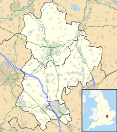
 Linslade
Linslade shown within BedfordshirePopulation 21,590 [1] OS grid reference SP910259 Parish Leighton-Linslade Unitary authority Central Bedfordshire Ceremonial county Bedfordshire Region East Country England Sovereign state United Kingdom Post town LEIGHTON BUZZARD Postcode district LU7 Dialling code 01525 Police Bedfordshire Fire Bedfordshire and Luton Ambulance East of England EU Parliament East of England UK Parliament South West Bedfordshire List of places: UK • England • Bedfordshire Linslade is an English town, located on the Bedfordshire side of the Bedfordshire-Buckinghamshire border (and roughly a third-way between London and Birmingham). It abuts onto the town of Leighton Buzzard with which it forms the civil parish of Leighton-Linslade. Linslade was transferred from Buckinghamshire in 1965, and was previously a separate urban district in its own right. It remained part of the Diocese of Oxford until 2008 when it joined Leighton Buzzard in the Diocese of St Albans. The original Anglo-Saxon settlement of Linslade, which was prominent during the 13th century, was not located at the modern site, but is to be found further north, and survives today as the hamlet of Old Linslade. The present location superseded the original during the 1840s, after massive growth associated with the construction of the Grand Union Canal and—particularly—the London and Birmingham Railway (Now known as the West Coast Main Line). Linslade underwent a second major period of expansion, again associated with the railways, during the 1970s.
Contents
Etymology
The name Linslade is Anglo Saxon in origin, and may mean 'river crossing near a spring'. (Though other plausible meanings exist.[2]) The original form, recorded—for example—in the Anglo-Saxon Chronicle of 966, was Hlincgelad; then linchlade, pronounced lince-lade but by the time of the Domesday Book, in 1086, it had become Lincelada.[3] The name continued to evolve, first appearing in its modern form in the 16th of 17th Century,[4] but with variations continuing into the 19th Century.[5]
History
Old Linslade
The earliest records of Linslade are of an Anglo-Saxon Manor, at the site of present-day Old Linslade, in 975 belonging to "Azelina", Ralph Tailbois' wife;.
After the Norman Conquest, in 1066, the manor was taken over by the de Beauchamps family. In 1251 a royal charter was granted to William de Beauchamp to hold a weekly market in Linslade, as well as a yearly 8-day fair. This grant was made on account of a Holy Well or Spring, located to the north of the village, which was a site of major pilgrimage. The holy well, which was a fabricated miracle to bring souls to the shrinking congregation of Old Linslade, was where the canal is sited today not far from the church.
In 1299, however, Oliver Sutton, Bishop of Lincoln, warned pilgrims off by threatening those who did not desist with excommunication. His reason for this is either that the well was unconsecrated[6] or that the miracles being attested to happen at the well were in fact fraudulent.[7] The vicar of Linslade, who did not dissuade the pilgrimages from visiting the spring because of the offerings they made, was forced to appear at the bishop's court.
Without the pilgrims, the importance of Linslade declined. But in the 15th century, the original 12th century church, dedicated to St Mary the Virgin, was rebuilt.
Chelsea New Town
A second settlement, known as Chelsea New Town, began growing to south of the original Linslade, on the Buckinghamshire-side of the crossing into Leighton Buzzard. At the beginning of the 19th Century the parish population was 203, but in 1805 the Grand Union Canal was opened on the Linslade-side of the River Ouzel, and in 1838 the London & North Western Railway built a railway line alongside the canal.[8] This precipitated a rapid growth in population around the station, so that by 1840 the parish of Linslade had 869 residents. This prompted the vicar of Linslade, the Rev. B. Perkins, to set about fundraising for a school for the parish's poor, and a church for the New Town. Fundrasing for the church was only completed by the Rev. Perkin's successor, Rev. Peter Thomas Ouvry; and its completion in 1849 marks the point that the New Town had become Linslade.
The name Chelsea Green exists as a street name in modern Linslade.
Bideford Green
From the 1840s onwards, Linslade grew steadily, although dipping during the Wars.[9] But at the end of 1960s a sustained period of development began which saw major housing estates added, so that by the end of the 1970s the town had over doubled in size. This saw an influx of commuters to these cheap houses, swelling of the population to something close to its present level.
Since the 1980s expansion has been constrained by Green Belt, with constructed limited to infilling packets of lands left undeveloped, or redeveloping older sites. But with the construction of the Linslade Western Bypass ( A4146 ), and the government demanding many more houses in the South-East, residents fear that a new period of expansion may be just around the corner.
Amenities
The expansion of Linslade during the 1970s added few additional amenities, besides houses, and so to this day Linslade relies on pre-existing facilities, many of which are Victorian in origin and—where those are insufficient—on Leighton Buzzard. Facilities are, however, managed jointly for the two towns (although see traffic, below, to understand why this can be a problem).
The principle Leighton-Linslade facilities within Linslade are Tiddenfoot Leisure Centre, which includes a swimming pool and indoor sports courts; and Leighton Buzzard Railway Station.
Commercial
Linslade has no high street. Small, family run shops are clustered at the "Centre of Linslade", where three arterial roads converge to cross the canal and river. (Note, however, that Linslade's "Centre" is not its geographical centre.) Many of these buildings are Victorian in origin, as are all pubs, and the Hunt Hotel.
In recent years the area between the river and the canal has been redeveloped – adding Tesco, Aldi, and Homebase superstores. Other high-street stores can be found in Leighton; or, failing that, at Milton Keynes. There are also corner shops on the estates.
Education
Bedfordshire operates a three-tier education system, with Lower-, Middle and Upper Schools. Linslade has three Lower Schools (Linslade Lower, Southcott Lower, and Greenleas Lower) distributed relatively evenly across town; with a Middle School (Linslade Middle) and an Upper school (The Cedars) located opposite each other, on the edge of town.
Catchment areas for the Leighton-Linslade mean that some Linslade children attend Middle School in Leighton Buzzard and some Leighton children attend Upper School in Linslade, adding to traffic problems.
Community facilities
The 1970s expansion added one community centre on Bideford Green, run by a Residents Association; this includes a small bar. This can be hired out for public use, and is used for dance lessons and martial arts, as well as a polling station. Dance classes can also be taken at another community centre – the Forster Institute; and the Leanne Hughes dance school next to the station. Linslade Parish Hall (St Barnabas' Church Hall – a school unto 1961) is used by many Leighton-Linslade organisations, including Tai Chi groups, and is undergoing a programme of renovation and extension. Nyamba Scout Hut is home to 1st Linslade Scouts and Guides, as well as playgroups.
Parks and playgrounds
Linslade has two semi-wild park areas. Linslade Wood (colloquially called Bluebell Wood) is a mature woodland dating back to at least the 16th Century. Tiddenfoot Pit, a former quarry, turned into a lake and wildlife area. Both are managed by Greensands Trust.
Additional there are parks suitable for teenagers to kick around a football, and for dogs to run about, as well as fenced off play areas for young children, containing slides and swings.
Sport
As well as being home to several junior football teams, Linslade is represented at senior level by local 5-a-side team, Sporting Linslade. Sporting Linslade are the current Division 3 champions, their only domestic trophy to date.[10] Sporting Linslade were chosen as the 5-a-side team of the year in the national Carling One-All Awards 2009.[11]
Status as a town
There is no straightforward answer as to question of whether Linslade is a town in its own right. It is possible that this is indeed the case, although with Linslade forming part of the administrative area of Leighton-Linslade; while it could equally be that Linslade is a district of a town called Leighton-Linslade, or more simply of Leighton Buzzard.
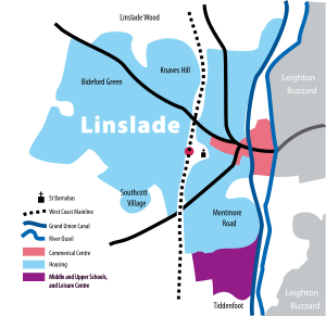 Schematic map of Linslade
The latter is argued for by the Post Office, who refuse to recognise Linslade in official postal addresses, notwithstanding the fact that on every road into Linslade, including the bridge over the river, there are prominent signs marking 'Linslade'. That said, even the most militant Linslader would understand the "town centre" to mean Leighton-Buzzard High Street, and the parish council of Leighton Linslade is referred to as the Town Council, on both sides of the river.
Linslade certainly owes it existence to a historical quirk; for if the county boundary had been elsewhere, then Chelsea New Town would have been considered part of Leighton Buzzard much earlier. The river, too, has played (and indeed continues to play) its part in keeping the two towns separate. But it is clear that Linslade and Leighton Buzzard are now part of a single urban entity, although it will likely be at least another a generation before the name and identity of that town emerge.
Infamous events
In 1963 the Great Train Robbery took place at a site near Bridego Bridge, between the villages of Cheddington and Linslade. Every time a Great Train Robber was caught law dictated that they had to be brought back to the small court house at Linslade to be charged.
In 1984 Malcolm Fairley, aka The Fox, conducted a series of assaults and rapes in Leighton Buzzard and the surrounding villages, several of which took place in Linslade.
Notable inhabitants
Famous residents include Hollyoaks actress Ciara Janson.
Tom Wise, the former Member of the European Parliament for the East of England jailed for expenses fraud lives in Linslade, as does Russell Stannard, author of several children's book and books on science and religion, and emeritus Professor of Physics at the Open University.
See also
- Southcote, Bedfordshire
- Leighton Buzzard railway station
- Leighton-Linslade
- Leighton Buzzard
- Cheddington
References
- ^ Bedfordshire County Council, Population Estimates and Forecasts, sum of 2007 estimates for Linslade and Southcott wards.
- ^ http://met.open.ac.uk/genuki/big/eng/bkm/Linslade/Index.html met.open.ac.uk
- ^ http://www.leighton-linslade.com/domesday/transcript2.html leighton-linslade.com
- ^ http://www.british-history.ac.uk/report.asp?compid=42585 british-history.ac.uk
- ^ http://www.leighton-linslade.com/name/linslade.html leighton-linslade.com
- ^ http://met.open.ac.uk/genuki/big/eng/bkm/Linslade/Index.html met.open.ac.uk
- ^ http://www.british-history.ac.uk/report.asp?compid=42585 british-history.ac.uk
- ^ http://www.linslade-parish.org.uk/History/History.htm linslade-parish.org.uk
- ^ http://www.leighton-linslade.com/populations/linslade.html leighton-linslade.com
- ^ Sporting Linslade
- ^ CARLING ONE-ALL AWARDS 2009 - THE WINNERS!
- 'Parishes: Linslade', A History of the County of Buckingham: Volume 3 (1925), pp. 387–91. http://www.british-history.ac.uk/report.asp?compid=42585 Date accessed: 15 September 2006
- History of a local school which became St Barnabas' Church Hall
- A history of the schools of Leighton Buzzard & Linslade, Maggi Stannard, 1990, ISBN 0-9514159-2-1.
- St. Barnabas' Church Linslade A History of the Church, Graham Gill
- Info on Linslade at the OU
External links
Playgroups
- Bluebell Playgroup (Southcott Lower School)
- Linslade Child Care (Linslade Lower School)
Schools
- Linslade Lower School
- Southcott Lower School
- Greenleas Lower School
- Linslade Middle School (Warning: javascript needed.)
- Cedars Upper School
Others
- Leighton-Linslade Town Council
- St Barnabas' Church
- 1st Linslade Scouts
- Sporting Linslade Football Club
- Linslade Woods
- Friends of Linslade Woods
Unitary authorities Major settlements Topics - Parliamentary constituencies
- Places
- SSSIs
- Visitor attractions
Categories:- Towns in Bedfordshire


Wikimedia Foundation. 2010.