- Toddington, Bedfordshire
-
Coordinates: 51°57′N 0°32′W / 51.95°N 0.53°W
Toddington 
 Toddington
Toddington shown within BedfordshirePopulation 4,459 (2001) OS grid reference TL009289 Parish Toddington Unitary authority Central Bedfordshire Ceremonial county Bedfordshire Region East Country England Sovereign state United Kingdom Post town DUNSTABLE Postcode district LU5 Dialling code 01525 Police Bedfordshire Fire Bedfordshire and Luton Ambulance East of England EU Parliament East of England UK Parliament Mid Bedfordshire List of places: UK • England • Bedfordshire Toddington is a large village and civil parish in the county of Bedfordshire, England which is situated 5 miles NNW of Luton, 4 miles (6 km) north of Dunstable, 6 miles (10 km) south west of Woburn and 35 miles NNW of London on the A5120 and B579. It is 0.5 miles from Junction 12 of the M1 motorway and lends its name to the nearby service station. The hamlet of Fancott also forms part of the Toddington civil parish.
It is situated near the motorway and many larger towns, however is built around a large village green, on which sits the parish church and four of the village's now six public houses. The Dunstable Northern Bypass taking heavy traffic bound for Dunstable from the M1 away from the village had been delayed but in Sept 2011 a restart was announced.[1] A large-scale housebuilding programme has been proposed by the government for the environs of Luton, Dunstable and Milton Keynes, and proposals to build a 20,000 seater football stadium was withdrawn in Feb 2007.
Many of the population commute to London for work[citation needed] using First Capital Connect rail services from Harlington and Leagrave. Toddington has experienced a rise in house prices due to its reputation as a quiet English village and the easy commute into London.
For local government purposes it is in Central Bedfordshire, and is in the Mid-Bedfordshire parliamentary constituency, represented since 5 May 2005 by the Conservative MP Nadine Dorries.
Contents
Amenities
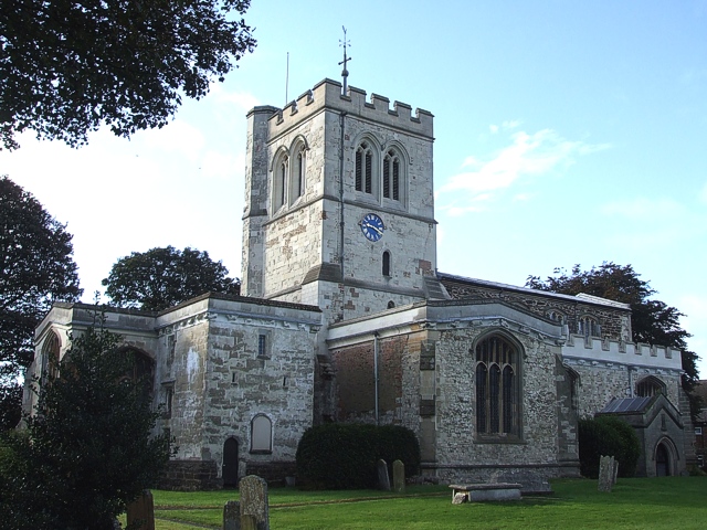
There are five churches, Church of England (St George), Anglican, Methodist, Baptist, and a Christian Fellowship.
Toddington reputedly had the most pubs per head of population of any village in the UK, although one has closed indefinitely and another turned into a restaurant. These include; The Bedford Arms,[2] the Oddfellows Arms, the Angel,[3] the Griffin,[4] the Bell (upper floors were badly damaged by fire on the 21st January 2010 but the pub opened again soon after), the Fancott Arms[5] and formerly the Nag's Head, Sow and Pigs (now closed indefinitely, July 2011), the Red Lion (turned into Ritzy Bar).
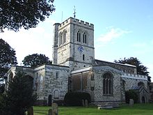 St George's Church
Toddington also has its own theatre - Tads Theatre, situated on Conger Lane. The theatre is owned and run by the charity group Tads Theatre, formerly known as the Toddington Amateur Dramatics Society. The group puts on between 4 and 6 in house productions a year, including an annual family pantomime.
Another well known entertainment feature of Toddington is the brass band. The Toddington Town Band (or TTB as it is known colloquially) performs regularly at village events. The Toddington Town Band has existed in one form or another since 1956.
The nearest mainline rail station is Harlington, which is located in the nearby village of Harlington and is served by First Capital Connect. From Harlington station, you can travel north to Flitwick and Bedford, or south to Luton, Luton Airport Parkway, St Albans, St Pancras International, Gatwick Airport and Brighton. The Fancott Arms hosts the ridable miniature railway (Fancott).
Dropshort Marsh lies immediately south of the village (51°56′19″N 0°32′16″W / 51.9385°N 0.5379°W). It is managed as a nature reserve by the local Wildlife Trust, and is designated a Site of Special Scientific Interest.[6][7]
Toddington is blessed with an excellent rights of way network so there are many walks around the village. A range of suggested walks are available on the website Lets Go, then search for Toddington. The Icknield Way Path passes through the village on its 110 mile journey from Ivinghoe Beacon to Knettishall Heath. The Icknield Way Trail, a multi-user route for riders and off-road cyclists also passes through the village.[8]
Schools
The village is served by two schools, Toddington St George Lower School and Parkfields Middle School which provide education for children aged between 4 and 13 years of age. After year 8, children transfer to Harlington Upper School located in the nearby village of Harlington.
Geography
Toddington is situated on a chalky plateau, Totternhoe Stone, which rises up to 100 ft above the other Mid-Bedfordshire villages (e.g. Westoning, Harlington, Flitwick).
Other information
Toddington Castle was a timber motte-and-bailey castle built before the 13th century in Toddington. Today only earthworks remain of the castle, known as Conger Hill. Chalgrave Castle was built to the south of the village during the 11th century, however no visible remains of the structure exist today.
Elizabeth I is reputed to have stayed in Toddington Manor.[citation needed] William Blake is said to have drunk at the Angel.[citation needed]
References
- ^ Highways Agency, A5-M1 Link (Dunstable Northern Bypass).
- ^ Bedford Arms
- ^ The Angel
- ^ The Griffin
- ^ The Fancott Arms
- ^ Wildlife Trust, Dropshort Marsh.
- ^ Natural England, Dropshort Marsh.
- ^ Icknield Way Trail
External links
- Toddington Parish Council
- St George's church
- Toddington Guest House
- Toddington Manor
- Ramblings from the Potting Shed in the blog of the Toddington Manor Head Gardener
- Toddington Poetry Society
- Toddington Residents Association
- Toddington Rovers Football Club
- Toddington Scout Group
- Toddington Tennis Club
- Toddington Town Band
Categories:- Villages in Bedfordshire
- Civil parishes in Bedfordshire


Wikimedia Foundation. 2010.