- Eyeworth
-
Coordinates: 52°05′41″N 0°10′43″W / 52.09459°N 0.1787°W
Eyeworth 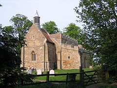
All Saints Church, Eyeworth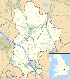
 Eyeworth
Eyeworth shown within BedfordshireOS grid reference TL248455 Unitary authority Central Bedfordshire Ceremonial county Bedfordshire Region East Country England Sovereign state United Kingdom Post town BIGGLESWADE Postcode district SG19 Dialling code 01767 Police Bedfordshire Fire Bedfordshire and Luton Ambulance East of England EU Parliament East of England UK Parliament North East Bedfordshire List of places: UK • England • Bedfordshire Eyeworth (also Eyworth) is a village and civil parish located in east Bedfordshire, England, around 5 miles north east of Biggleswade.
It is now part of the parish of Sutton and Eyeworth which had a combined population of 385 in 2001, of which 86 were estimated to be part of Eyeworth itself.[1]
Despite its small size Eyeworth is mentioned in the Domesday Book. The majority of the houses are Victorian, though the seventeenth century Church Farm still remains.
The widow of Francis Bacon, née Alice Barnham, lived in Eyeworth following his death, and she died there in 1650. There were a number of minor skirmishes in the parish during the Civil War and it is reputed that Oliver Cromwell visited the village and damaged some of the church's icons.[2]
All Saints Church
The village is home to a medieval church dedicated to All Saints whose current building dates back to the fourteenth century and is partly constructed from Totternhoe stone. The church's fifteenth century spire was destroyed by lightning in 1967 and after the subsequent theft of the lead from its roof was replaced by a much smaller modern turret.[2]
The interior houses a number of medieval brasses and monuments to Sir Edmund Anderson (d.1605), founder of the Anderson line who were lords of the manor, and who was also a judge during the trial of Mary, Queen of Scots.
References
- ^ "Parish Profile for Sutton / Eyeworth". Bedfordshire County Council. http://www.galaxy.bedfordshire.gov.uk/webingres/bedfordshire/census/parish-profiles/pp-sutton-eyeworth.htm.
- ^ a b Alan Castle (2001). Walking in Bedfordshire. Cicerone Press Ltd.
External links
 Media related to Eyeworth at Wikimedia CommonsCategories:
- Villages in Bedfordshire
- Civil parishes in Bedfordshire
- Bedfordshire geography stubs


Wikimedia Foundation. 2010.