- Maulden
-
Coordinates: 52°02′N 0°28′W / 52.03°N 0.47°W
Maulden 
 Maulden
Maulden shown within BedfordshirePopulation 2,900 (2001) OS grid reference TL048377 Parish Maulden Unitary authority Central Bedfordshire Ceremonial county Bedfordshire Region East Country England Sovereign state United Kingdom Post town Bedford Postcode district MK45 Dialling code 01525 Police Bedfordshire Fire Bedfordshire and Luton Ambulance East of England EU Parliament East of England UK Parliament Mid Bedfordshire List of places: UK • England • Bedfordshire Maulden is a small village and civil parish located in the county of Bedfordshire, in the administrative area of Central Bedfordshire, in the newly created Maulden And Houghton Conquest Ward. An active Parish Council meets monthly- the clerk is Lynda Galler [1]. The village is located 1.5 miles east of Ampthill and about 8 miles (13 km) south of Bedford. It has about 1,100 homes and 2,900 residents.[1] Recently, the number of people in the village has increased with a new housing development by Croudace Homes which has brought 46 new houses to the village.[2].
Maulden is referred to in the Domesday Book as Meldone and the meanings ascribed to the various versions of the name include "cross on the hill", "high down" and "place of meeting". The current MP for the area is Nadine Dorries.
Maulden also holds the coveted title of 'Britain's Longest Village'.
Contents
Amenities
Maulden has a branch of the The Co-operative Group a thriving community convenience, open 7 days a week. The village also includes a small Post Office. Its pubs and eaterys include: The George, The White Hart;a 17th Century thatched centrepiece of Village, [3], The Dog & Badger and The Black Horse. It has a primary school, Maulden Lower School for ages 4 to 9- with after school club ([4]), and for Middle School and Upper School provision, children must go to the nearby Ampthill, Alameda Middle and Redborne School. There is also a Local Authority run Pre-School [5] and a private nursery - Tudor Court. There are also two small industrial estates to the south east of the village. These are primarily agricultural, but also contain some light chemical installations and offices. The only youth facility in the village is a recreation ground in the west of the village which is home to the Maulden Magpie's Football Club, now recently improved to a Football Foundation ground. [6]. The village hall hosts a number of functions and groups who meet there including the Maulden Baby and Toddler Group, who meet there on most Wednesday mornings, jumble sales, exercise classes etc. Each year the Maulden Players perform a pantomime with contributions from many members of the village and surrounding communities. This year (2008) was Sleeping Beauty.[7].
Church
 A picture of the Parish Church
St Mary the Virgin church is the parish church of Maulden. It stands on the Greensand Ridge to one side of the village main road, commanding imposing views over the village and surrounding Mid-Bedfordshire countryside. There are church services every Sunday and throughout the week. The weekly sermon can be heard on the internet. Sermon The church has an active community, with a variety of different events taking place.
There is one Rectory for the Parish of St Marys the Virgin. The current incumbent is Rev. Richard Winslade. There is also a Baptist church.
History
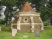 A picture of the Mausoleum
In 1824 the church consisted of the tower, a nave with a very low roof (it was reported in the Bedford Mercury of October 1858 that during a heavy downpour it was difficult to hear the sermon), a chancel with a slightly higher roof, a north aisle and gallery. This gallery was quite large, and because of the low roof came down to only two feet above the tops of the pews underneath, as well as blocking the light from two of the windows. The pews, some of which faced different ways, provided seating for 248, plus 40 in the gallery. There was no south aisle and no vestry. There was a south entrance with a porch, and a doorway in the north wall, next to the passageway to the Ailesbury mausoleum. The bell tower is in active use and includes a mechanical westminster "chime" which is a distinctive sound in the village.
In the churchyard stands a 17th century mausoleum and crypt known as the Ailesbury Mausoleum (pictured). The original mausoleum was built by Thomas, Earl of Elgin, in memory of his second wife Diana, daughter of the Earl of Stamford. The mausoleum and crypt are sometimes open to visitors during the summer months. On August 6, 2008, lead was stolen from the roof of the mausoleum causing at least £10,000 worth of damage.
Census
The 1851 Census Index for Maulden can be found in the 1851 Index to Census of Bedfordshire, Volume 4, Book 2 available from the Bedfordshire Family History Society. More recent surveys are available from the National Audit Office.
History
Maulden was a parish in the union of Ampthill, hundred of Redbornestoke, county of Bedford, 1½ miles from Ampthill; containing 1330 inhabitants. The parish comprised nearly 3000 acres (12 km²), of which 260 were woodland and plantations, and of the remainder, two thirds were arable and one third pasture.
Many of the women were employed in lacemaking and the plaiting of straw. There were some quarries of sandstone; and a pleasure fair was held in the week nearest to St. Bartholomews-day.
The living was a rectory, valued in the King's books at £15.9.7; net income £512; patron, the Marquess of Ailesbury. The tithes were commuted for land and a corn rent, under an act of enclosure in 1796. The church, principally in the latter English style, was, with little intermixture, completely restored in 1837. There were places of worship for baptists and Methodists.[2]
Surrounding scenery
Maulden is surrounded by arable land and rolling pasture hills to the west, allotments and more arable land to the south, and hilly pasture to the east. To the northeast, Maulden Wood stretches over to the ancient road, the A6. Directly north lies Kings Wood and to the Northwest is Houghton House on the Bedfordshire Greensand Ridge Path.
Maulden Players
Maulden Players are an amateur dramatics society who meet weekly at Maulden Village Hall on a Monday night and 2 - 3 times a year put on performances for public audiences. The Players were founded in 1983 under the former guise of St. Mary's Parish Players. Originally only putting on one performance a year with the pantomime in January, the Players soon added more productions to their calendar which usually include a play in May/June for the adult members of the group and a youth production around September/October.
External links
- Website of the Parish Church
- Maulden Players Official Website
- Maulden's Windows and Conservatory Family Run Company
- Website of Maulden History Society
- Website of Maulden Pre-School
References
- ^ Office for National Statistics : Census 2001 : Parish Headcounts : Mid Bedfordshire Retrieved 16 October 2010
- ^ A Topographical Dictionary of England – Samuel Lewis – 1831
Categories:- Villages in Bedfordshire
- Civil parishes in Bedfordshire
- Ampthill


Wikimedia Foundation. 2010.