- Cublington
-
Coordinates: 51°53′33″N 0°46′45″W / 51.8926°N 0.7791°W
Cublington 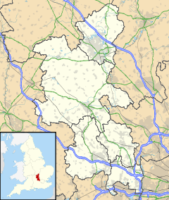
 Cublington
Cublington shown within BuckinghamshirePopulation 338 [1] OS grid reference SP835225 Parish Buckingham District Aylesbury Vale Shire county Buckinghamshire Region South East Country England Sovereign state United Kingdom Post town LEIGHTON BUZZARD Postcode district LU7 Dialling code 01296 Police Thames Valley Fire Buckinghamshire Ambulance South Central EU Parliament South East England UK Parliament Buckingham List of places: UK • England • Buckinghamshire Cublington is a village and one of 110 civil parishes[2] within Aylesbury Vale district in Buckinghamshire, England. It is about seven miles (11 km) north of Aylesbury. The village name is Anglo Saxon in origin, and means 'Cubbel's estate'. In the Domesday Book of 1086 it was recorded as Coblincote.
The parish church of St Nicholas is built in the perpendicular style. The tower of the church is decorated with blank tracery windows. Inside, the chancel arch has unusual corbels of a man and a monkey. At one time there was also a Methodist Chapel in the village.
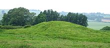 The Beacon
500 yards (500 m) from the church is a small man-made hill, about 20 ft (6.1 m). high, known as "The Beacon", it is in fact the motte of a small Norman castle.[3]
North west of the church the 18th century stable block of the former manor house survives, it is an impressive building built of brick. A granary also survives built on an arcaded basement. This is rare as granaries in the area tended to be built on saddle stones. This type of agricultural building was generally raised from the ground to deter rodents.
There are some houses of note, these include: Old Manor Farm, a large low house with a recently created series of spectacular gardens; and opposite the church, the former rectory, dating from the 18th century with more recent additions, and an informal garden, open to the public once or twice a year. Neales Farm is an H plan half-timbered house dating from circa 1600.
The village has many old cottages, as well as small enclaves of newly built houses.
In 1971, the Report of the Roskill Commission on the Third London Airport selected Cublington as the location of a proposed third airport for London on the basis of cost-benefit analysis.[4] The government later rejected the recommendation due to quality of life concerns in favour of a site at Maplin Sands, Foulness.[5]
The village pub is called "The Unicorn".
References
- ^ Neighbourhood Statistics Census 2001
- ^ Ayelsbury District Council web site. Retrieved 30 June 2009
- ^ Cublington, The Beacon (Pastscape)
- ^ Parliamentary Debates, House of Commons, March 4, 1971.
- ^ Patterson, Walt (1973) Airports, Concorde in trouble Environment: London Report Retrieved 15 July 2009
External links
Categories:- Villages in Buckinghamshire
- Civil parishes in Buckinghamshire

Wikimedia Foundation. 2010.