- Cuddington, Buckinghamshire
-
Coordinates: 51°47′37″N 0°55′45″W / 51.793671°N 0.929061°W
Cuddington 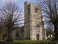
St Nicholas's Church, Cuddington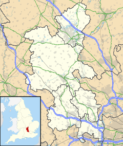
 Cuddington
Cuddington shown within BuckinghamshirePopulation 545 [1] OS grid reference SP738111 District Aylesbury Vale Shire county Buckinghamshire Region South East Country England Sovereign state United Kingdom Post town AYLESBURY Postcode district HP18 Dialling code 01844 Police Thames Valley Fire Buckinghamshire Ambulance South Central EU Parliament South East England UK Parliament Buckingham List of places: UK • England • Buckinghamshire Cuddington is a village and civil parish within Aylesbury Vale district in Buckinghamshire, England. It is near the Oxfordshire border, about six miles west of Aylesbury.
The village name is Old English (Anglo-Saxon) in origin, and means "Cudda's estate." In the Domesday Book of 1086 it was recorded as Cudintuna. Anciently the village was the location of a medicinal spring of great repute, though its exact location is unknown. The Church of St Nicholas dates from the 12th Century but was much restored in 1857. Across the road is Tyringham Hall that dates from the 17th Century. During the Second World War the King of Norway who was staying at the nearby Hartwell House attended a church service in the village.
Cuddington is centred around the village green and the road junction linking Aylesbury, Long Crendon and Haddenham. The majority of the original houses were built on the north side but in the last 50 years or so new homes have been built predominantly on the south side.
The current population is around 550 residents. Two of the most famous former residents were Jonathan and David Dimbleby.
The village, like surrounding villages, has been the location of several Midsomer Murders episodes.
Facilities in the village include:
- Shop/post office
- Hairdressing salon
- Pub/Restaurant
- 2 Churches (although one of these is rarely used)
- Village Hall
- Playing Field with Clubhouse, Tennis Courts, Children's Park and Cricket and Football pitches
For many years the village has won the regional heat of Britain's Best Kept Village Competition and also the Britain in Bloom competition.
Cuddington and Dinton Church of England School is a mixed Church of England primary school. It is a voluntary aided school, which takes children from the age of four through to the age of eleven. Cuddington was an infant school but has recently merged with Dinton School to form a full primary school on two sites. There are now just over one hundred pupils on roll.
References
External links
- Cuddington Village Website
- Cuddington and Dinton Church of England School
- Cuddington Kites Cricket Club
Famous residents past and present
- David Dimbleby – Broadcaster
- Jonathan Dimbleby – Broadcaster
- John Holyman – 16th century Bishop of Bristol
Categories:- Villages in Buckinghamshire
- Civil parishes in Buckinghamshire
- Buckinghamshire geography stubs


Wikimedia Foundation. 2010.