- Wing, Buckinghamshire
-
Coordinates: 51°53′53″N 0°43′01″W / 51.898°N 0.717°W
Wing 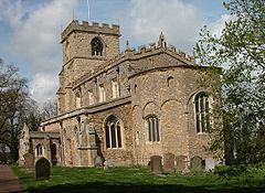
All Saints' parish church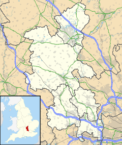
 Wing
Wing
Wing shown within BuckinghamshirePopulation 2,897 (2001 census)[1] OS grid reference SP882229 Parish Wing District Aylesbury Vale Shire county Buckinghamshire Region South East Country England Sovereign state United Kingdom Post town Leighton Buzzard Postcode district LU7 Dialling code 01296 Police Thames Valley Fire Buckinghamshire Ambulance South Central EU Parliament South East England UK Parliament Buckingham Website Wing Village List of places: UK • England • Buckinghamshire Wing is a village and civil parish in Aylesbury Vale district in Buckinghamshire, England. The village is on the main A418 road between Aylesbury and Leighton Buzzard. It is about 8 miles (13 km) north east of Aylesbury, 3 miles (4.8 km) west of Leighton Buzzard and 12 miles (19 km) south of Milton Keynes.
Contents
History
The Domesday Book of 1086 records the toponym as Witehunge and in Old English circa 966–975 as Weowungum (dative plural case). It could mean:-
- "Wiwa's sons or people".
- "The dwellers at, or devotees of, a heathen temple."
The first syllables of the names of the nearby village of Wingrave and the nearby hamlet of Wingbury have the same etymology.
The remains of the temple referred to may be under the Anglo-Saxon Church of England parish church of All Saints.[citation needed]
The BBC Television programme Meet the Ancestors came to Wing in 2000 and recreated the face of an Anglo-Saxon girl found buried in the old graveyard.
Wing also has the oldest continuously used religious site in the country,[citation needed] with evidence showing the site has had religious use going back well over 1300 years. The Anglo-Saxon origin of All Saints' parish church makes it one of the oldest churches in England.[citation needed]

An ancient track, part of the pre-historic Icknield Way linking Oxford with Cambridge, once passed through the village. This was still use din the Middle Ages and led to an increase in the village's size, though with the advent of modern roads and motorways this is less used today.
As early as the 7th century there was an abbey near the village at Ascott, that had been built by an unknown member of the House of Wessex royal family and given to a Benedictine convent in Angers. The Anglo-Saxon church in Wing, dedicated to All Saints, was also built at about this time for St Birinus,[2] but evidence found in the 15th century during extensive renovations on the church suggest a Roman structure had stood on this site beforehand.[3] Roman tiles[clarification needed] may also be found in the ceiling of the crypt of the church.
It is unusual among religious buildings of this age for the church and abbey to be built apart: if they were built at the same time it was normal for them to be constructed within the same complex of buildings. One possible explanation for this is that the church was built on a pre-existing religious site, which the evidence in the village's name and in the aforementioned archeological finds seem to suggest. The church contains a number of fine monuments, including the "purest Renaissance monument of the mid-16th century" to Sir Robert Dormer (died 1552) and a wall monument attributed to Louis-François Roubiliac.

Wing came to prominence in the 20th century when the location of a new London airport was being discussed, and Wing was one of the prime locations for it. A community campaign was organised, called the 'Wings Off Wing Campaign', and was successful: the airport at Heathrow was expanded instead. The disused RAF Wing is now a chicken farm but the layout of the runways can still be seen from the air.
Amenities
Wing has three public houses, a social club and a police station.
Wing has two schools. Overstone Combined School is a mixed, foundation primary school for children aged 4–11.[4] Cottesloe School is a secondary school for children aged 11–18.[5]
Ascott House, a home of the Rothschild family, is in the parish.
References
- ^ "Area: Wing CP (Parish): Parish Headcounts". Neighbourhood Statistics. Office for National Statistics. http://www.neighbourhood.statistics.gov.uk/dissemination/LeadTableView.do?a=7&b=792108&c=wing&d=16&e=15&g=424490&i=1001x1003x1004&m=0&r=1&s=1216766250073&enc=1&dsFamilyId=779. Retrieved 22 April 2011.
- ^ All Saints Church history
- ^ Britain Express website
- ^ Overstone Combined School
- ^ The Cottesloe School
Further reading
- Page, W.H., ed (1905). A History of the County of Buckingham, Volume 1. Victoria County History. Archibald Constable & Co. p. 396.
- Page, W.H., ed (1925). A History of the County of Buckingham, Volume 3. Victoria County History. pp. 449–458.
- Pevsner, Nikolaus (1973) [1966]. Buckinghamshire. The Buildings of England. Harmondsworth: Penguin Books. pp. 294–296. ISBN 0 14 071019 1.
External links
-
- David Nash Ford: Wing Church, Buckinghamshire - Saxon Apse & Crypt
- David Nash Ford: Wing Church, Buckinghamshire - Monuments
- 1st Wing Scout Group
Categories:- Villages in Buckinghamshire
- Civil parishes in Buckinghamshire
- English mythology
- Germanic mythology
- Non-Christian religious placenames in Britain


Wikimedia Foundation. 2010.