- Queenborough
-
Coordinates: 51°25′06″N 0°44′42″E / 51.4183°N 0.7450°E
Queenborough 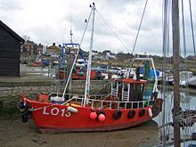
The Creek
 Queenborough
Queenborough shown within KentPopulation 3,471 OS grid reference TQ908724 District Swale Shire county Kent Region South East Country England Sovereign state United Kingdom Post town QUEENBOROUGH Postcode district ME11 Dialling code 01795 Police Kent Fire Kent Ambulance South East Coast EU Parliament South East England UK Parliament Sittingbourne and Sheppey List of places: UK • England • Kent Queenborough is a small town on the Isle of Sheppey in the Swale borough of Kent in South East England.
Queenborough is two miles (3.2 km) south of Sheerness. It grew as a port near the Thames Estuary at the westward entrance to The Swale where it joins the River Medway. It is in the Sittingbourne and Sheppey parliamentary constituency.
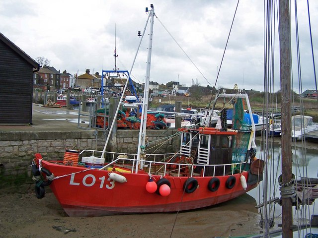
Queenborough Harbour offers moorings between the Thames and Medway. It is possible to land at Queenborough on any tide and there are boat builders and chandlers in the marina. Admiral Lord Nelson, is reputed to have learnt much of his seafaring skills in these waters, and also shared a house near the small harbour with his mistress, the Lady Hamilton.
Queenborough today still reflects something of its original 18th century seafaring history, from which period most of its more prominent buildings survive. The church is the sole surviving feature from the medieval period. The town was first represented by two Members of Parliament in 1572.
Contents
History
Saxon
In Saxon times, the settlement on the site was known as Cyningburh, "King's Borough".[1]
Medieval
A fortress, called Sheppey or Queenborough Castle, was built to guard the passage of ships along the Swale upon the command of King Edward III between 1361-1377, during the Hundred Years' War with France. It was built on the site of a much earlier, but smaller castle.[2] This later fortress was a round symmetrical one with 70 rooms, modelled on French-style chateaux of the period; it regained importance in the 16th century under Thomas Cheney, when it is thought to have influenced the construction of nearby Deal Castle and Walmer Castle.
In those days north Kent was divided by open waters and marshes stretching inland. The safest navigation to the open sea was then the route from the Thames into the Yantlet Creek (separating the Isle of Grain from the rest of Hoo Peninsula), and thus into the Swale from the Medway estuary, around the leeward side of the Isle of Sheppey into the Wantsum Channel, navigating past the Isle of Thanet to Sandwich and only then into the open waters of the English Channel. It was thus an easily defensible planned-town centre for the wool trade.
King Edward III had the town renamed after his Queen, Philippa of Hainault, and conferred upon it the rights of a free borough, with a governing body of a mayor and two bailiffs. He granted Queenborough a charter in 1366 and two years later bestowed the duties of a royal borough upon it.
During this period, Queenborough, on the Isle of Sheppey was an important town for the export of wool, a significant crown revenue. From 1368: "By Royal decree, the Wool Staple was transferred from Canterbury to Queenborough, which, together with Sandwich, became one of the only two places in Kent through which all the exported wool was compulsorily directed."
The castle was excavated in 2005 by Time Team.[3]
17th century
King Charles I had the town re-incorporated under the title of the "mayor, jurats, bailiffs and burgesses of Queenborough", during which time the population was chiefly employed in the local oyster fishery. However the fort having protected the Swale and Medway estuaries for 300 years was never in fact to realise its function as a garrison, and recorded no active military history. After being seized by Parliamentarians in 1650, and being considered unsuitable for repair, being of "no practical use" it was demolished during the interregnum.
Not long after this, in 1667, the Dutch captured the new Sheerness fort (then under construction) and invaded Queenborough. The occupation lasted only a few days; though the Dutch caused widespread panic, they were unable to maintain their offensive, and withdrew having captured the Royal Charles and burnt numerous other ships in the Thames and Medway. Following this raid on the Medway much-needed attention was given to the improvement of the naval defences of the Medway, which at length helped strengthen the economy of Queenborough and Sheppey. Some 300 years later in 1967, The Queenborough and Brielle (the Netherlands) twinning project was established.
19th century to date
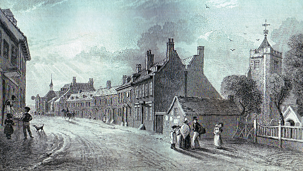
 View of Queenborough ca. 1830.
The parish church was overhauled during 1690 to 1730, and a number of houses added to the growing town during the 18th century. With the general prosperity of the colonial and mercantile trades of the age, Queenborough thrived. However early in the 19th century, change was again visited upon the ancient settlement. "Queenborough in the 1850s was a very sorry place indeed; broken down and almost lawless."
With the silting up of the Yantlet creek and the Wantsum channel and improved navigation through the Thames estuary to London, Queenborough began to lose its importance, becoming something of a backwater. Daniel Defoe described it as "a miserable and dirty fishing town (with) the chief traders ... alehouse keepers and oyster catchers".
The Royal Navy eventually became less prominent on the River Medway as other dockyards developed and ships grew in size, so that they were largely replaced by prison hulks which would frequently dispose of their dead charges on a salt marsh at the mouth of The Swale, which was subsequently to become known as Dead Man's Island, and can still be found as such, on local maps today. The new fort and harbour developments completed at Sheerness by this time further replaced Queenborough by being better positioned at the mouth of the Medway.
It is all the same worth noting as evident from records between 1815-20 that the Corporation of Queenborough was in some financial difficulties, owing some £14,500 that it could not hope to pay. It appears that the mayor and other officials had been less than honest in their duties toward the community, with the use of the public money at their disposal. This fraud caused a great financial burden upon the fisherman and oystermen, who were driven to "unlawful and riotous assembly", in protest against unwarranted charges made upon them in the course of their trade.
So serious had this deterioration in conditions become, that by the middle of the 19th century the Corporation was bankrupt, and Parliament was called upon to act, vesting by an Act of Parliament much of the town's business in the hands of trustees who were able to refinance the economy by selling land, property and the ancient oyster fishery. The oyster trade having been corrupted by smuggling and the bribery of the island's Members of Parliament, it lost its franchise in the Reform Act of 1832.
A Borough Charter granted in 1885 gave some renewed impetus to the struggling borough council, but it was not until 1937 that the Charity Commissioners were at last able to appoint a borough council, but the town and its fisheries never fully recovered. The present trustees are Swale Borough Council, which incorporated the old borough council in the reorganisation of 1974. Queenbrough now has a town council, which includes a mayor.
Unsightly modern sea wall defences have hindered the character of the beaches but were deemed necessary; a large yachting harbour exists, where the pirate radio ship Radio Caroline (in the river Medway 2003-4) anchored for a while. Tourism is today a major feature of the island, with Queenborough enjoying some of the fruits of local investment.
Matthias Falconer of Brabant established the first copperas factory in England at Queenborough in 1579.
The economy of Queenborough was boosted significantly by the establishment of a branch line from Sittingbourne by the South-Eastern & Chatham Railway which operated in conjunction with a mail and passenger service by steamer to Flushing in the Netherlands. The Swale was bridged when the railway was built in 1860.
From the town's depression in the 1850s there began a process of recovery. New industries came to Queenborough including a glass works and a company engaged in coal washing. Besides these many other small industries developed, including potteries, the Sheppy Fertilizer company (which used the old spelling of Sheppey) and the glue works. The Portland cement works opened in 1890, and there is still a considerable trade in timber.
Government
Queenborough is in the parliamentary constituency of Sittingbourne and Sheppey. Since 1997, the constituency's Member of Parliament has been Derek Wyatt of the Labour Party.[4]
Queenborough is within the Swale local government district and its electoral ward of Queenborough and Halfway. This ward has three of the forty seven seats on the Swale Borough Council. As of the 2007 Local Elections, two of those seats were held by the Labour Party and one by the Conservative Party.[5]
The town council at one point had an Official Monster Raving Loony Party mayor.
Demographics
Queenborough Compared 2001 UK Census Queenborough Swale District England Total population 3,471 122,801 49,138,831 Foreign born 2.8% 3.6% 9.2% White 99% 98% 91% Asian 0.4% 0.7% 4.6% Black 0.3% 0.3% 2.3% Christian 78% 76% 72% Muslim 0.1% 0.4% 3.1% No religion 15% 15% 15% Over 65 years old 13% 16% 16% Bachelor's degree or higher 7% 12% 20% As of the 2001 UK census, the parish of Queenborough had a population of 3,471.[6]
For every 100 females, there were 94.5 males. The age distribution was 7% aged 0-4 years, 18% aged 5-15 years, 10% aged 16-24 years, 28% aged 25-44 years, 23% aged 45-64 years and 13% aged 65 years and over.[6]
The ethnicity of the Queenborough and Halfway electoral ward, which includes the neighbouring villages of Minster-on-Sea, Rushenden and Halfway Houses, was 98.6% white, 0.7% mixed race, 0.3% black, 0.2% non-Chinese Asian and 0.3% Chinese or other.[6]
The place of birth of Queenborough and Halfway residents was 97.2% United Kingdom, 0.6% Republic of Ireland, 0.4% Germany, 0.3% other Western Europe countries, 0.3% Far East, 0.3% Africa, 0.3% North America, 0.2% South Asia, 0.2% Oceania and 0.1% Middle East.[6]
Religion was recorded as 77.6% Christian, 0.1% Muslim and 0.1% Jewish. 14.7% were recorded as having no religion, 0.3% had an alternative religion and 7.7% didn't state their religion.[6]
7% of Queenborough and Halfway residents aged 16-74 had a Bachelor's degree or higher, compared to 20% nationally.[6]
Economy
A modern pharmaceutical factory and laboratories, and a steel rolling mill are among the more recent developments, but the mill has suffered greatly as a result of the restrictions in place by the American steel trade. Considerable unemployment is expected locally.
As of the 2001 UK census, the economic activity of residents aged 16–74 of Queenborough and its neighbouring villages of Minster-on-Sea, Rushenden and Halfway Houses was 42.0% in full-time employment, 12.7% in part-time employment, 7.1% self-employed, 3.4% unemployed, 1.5% students with jobs, 3.0% students without jobs, 14.6% retired, 8.0% looking after home or family, 5.3% permanently sick or disabled and 2.4% economically inactive for other reasons. The unemployment rate of 3.40% was similar to the national rate of 3.35%.[6]
The industry of employment of residents was 24% manufacturing, 16% retail, 9% construction, 9% real estate, 10% transport & communications, 7% health & social work, 7% public administration, 5% education, 4% hotels & restaurants, 2% finance, 1% agriculture and 3% other community, social or personal services. Compared to national figures, the town had a relatively high percentage of workers in manufacturing, construction, public administration and transport & communications, and a relatively low percentage in agriculture, health & social work, education, finance and real estate.[6]
Transport links
Trains pass through Queenborough railway station on the Sheerness Line between Sittingbourne, where the line links with the rest of the network, and Sheerness.
Sources
- J C Varker [1]
- 'Queenborough and its oysters', Geoffrey Hufton. (Bygone Kent Vol.3, No 7)
- Sheppey Gazette
- Population figures
See also
References
- ^ Lewis, Samuel (1848). A Topographical Dictionary of England. pp. 623–627.; Isaac Taylor, Names and Their Histories: A Handbook of Historical Geography 1898:230.
- ^ Lewis, Samuel (1848). A Topographical Dictionary of England. pp. 623–627.
- ^ "Queenborough Kent". Channel 4. 2006-03-12. http://www.channel4.com/history/microsites/T/timeteam/2006_queen.html. Retrieved 2010-02-10.
- ^ "Derek Wyatt". Guardian.co.uk. http://politics.guardian.co.uk/person/0,9290,-5704,00.html. Retrieved 2007-04-29.
- ^ "List Councillors By Ward". Swale Borough Council. http://www.swale.gov.uk/dso/CouncillorsBy.asp?SortOrder=Ward. Retrieved 2007-03-29.
- ^ a b c d e f g h "Neighbourhood Statistics". Statistics.gov.uk. http://neighbourhood.statistics.gov.uk/dissemination/LeadAreaSearch.do?a=3&i=1001&m=0&enc=1&areaSearchText=Queenborough+and+Halfway&areaSearchType=14&extendedList=false&searchAreas=Search. Retrieved 2007-03-29.
Towns and villages in the Borough of Swale in Kent, England 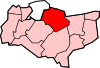 Bapchild · Badlesmere · Bay View · Bobbing · Borden · Boughton Street · Boughton under Blean · Bredgar · Brogdale · Buckland · Chestnut Street · Conyer · Dargate · Davington · Denstroude · Doddington · Dunkirk · Eastchurch · Eastling · Elmley · Faversham · Faversham Without · Goodnestone · Graveney · Halfway Houses · Hartlip · Harty · Heart's Delight, Swale · Hernhill · Highsted · Iwade · Kemsley · Keycol · Kingsdown · Leaveland · Leysdown-on-Sea · Lower Halstow · Luddenham · Lynsted · Milstead · Milton Regis · Minster · Mockbeggar · Murston · Newington · Newnham · Norton · Oad Street · Oare · Ospringe · Oversland · Painters Forstal · Queenborough · Rodmersham Green · Rushenden · Selling · Sheldwich · Shellness · Sheerness · Sittingbourne · Stalisfield Green · Teynham · Throwley · Tonge · Tunstall · Upchurch · Uplees · Warden · Waterham · Whitehill
Ceremonial county of Kent Unitary authorities Boroughs or districts Major settlements - Ashford
- Broadstairs
- Canterbury
- Chatham
- Cranbrook
- Dartford
- Deal
- Dover
- Edenbridge
- Faversham
- Folkestone
- Fordwich
- Gillingham
- Gravesend
- Greenhithe
- Herne Bay
- Hythe
- Lydd
- Maidstone
- Margate
- Minster
- New Romney
- Northfleet
- Paddock Wood
- Queenborough
- Rainham
- Ramsgate
- Rochester
- Royal Tunbridge Wells
- Sandwich
- Sevenoaks
- Sheerness
- Sittingbourne
- Snodland
- Southborough
- Strood
- Swanley
- Swanscombe
- Tenterden
- Tonbridge
- Walmer
- West Malling
- Westerham
- Westgate-on-Sea
- Whitstable
See also: List of civil parishes in Kent
Rivers See: Rivers of KentTopics Categories:- Swale
- Towns in Kent


Wikimedia Foundation. 2010.