- Doddington, Kent
-
Coordinates: 51°16′53″N 0°46′23″E / 51.2815°N 0.773°E
Doddington 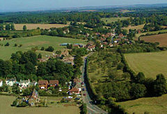
Aerial photo of Doddington
 Doddington
Doddington shown within KentDistrict Swale Shire county Kent Region South East Country England Sovereign state United Kingdom Police Kent Fire Kent Ambulance South East Coast EU Parliament South East England List of places: UK • England • Kent Doddington is an affluent rural English village, in the south eastern county of Kent, within the borough of Swale. A picturesque village nestling in the 'Syndale Valley' which is in the Kent Downs and is designated an Area of outstanding natural beauty. Today the village is popular with commuters to London and retired people who are attracted by its quiet charm.
Within the parish at Sharsted Court, earthworks excavated were believed remains of an Iron Age Belgic Fort (100-43BC). However the current village settlement dates from the 11th Century. The village has a garage (Doddington Service Station), one pub (The Chequers Inn) which also acts as a post office. A multi-award winning butchers (Doughtys) owned by the Doughty family since 1919 and a butcher's shop since 1789. Of particular note is Doddington Church with the unusual dedication of "The decollation (beheading) of St John the Baptist". The dedication dates from at least 1467 when it is referenced in a will.
 Doddington Church 2006
Other notable buildings within the Parish are: Doddington Place built in 1870 for the Croft family (of 'Croft original sherry' fame) [1] who owned it until 1906 when the Jefferies and Oldfied families jointly purchased it. It is still owned by the Oldfield family and the gardens are open to the public.
Nearby is Sharsted Court, a Medieval Hall house, however a building on the site dates from at least 1080. Today Sharsted Court is a large romantic rambling manor house due to the many additions and alterations over the centuries. It is owned by former Wimbledon champion Virginia Wade.
Every Christmas the local Thespian group The Valley players put on an outstanding village Pantomime, adding their own twist to the traditional plays. In 2011 they shall be performing Mother Goose.
References
External links
- Doddington Village Website
- The Official Chequers Inn website
- Doddington Place Gardens
- Kent Downs, AONB
- Doddington, location
Towns and villages in the Borough of Swale in Kent, England 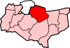 Bapchild · Badlesmere · Bay View · Bobbing · Borden · Boughton Street · Boughton under Blean · Bredgar · Brogdale · Buckland · Chestnut Street · Conyer · Dargate · Davington · Denstroude · Doddington · Dunkirk · Eastchurch · Eastling · Elmley · Faversham · Faversham Without · Goodnestone · Graveney · Halfway Houses · Hartlip · Harty · Heart's Delight, Swale · Hernhill · Highsted · Iwade · Kemsley · Keycol · Kingsdown · Leaveland · Leysdown-on-Sea · Lower Halstow · Luddenham · Lynsted · Milstead · Milton Regis · Minster · Mockbeggar · Murston · Newington · Newnham · Norton · Oad Street · Oare · Ospringe · Oversland · Painters Forstal · Queenborough · Rodmersham Green · Rushenden · Selling · Sheldwich · Shellness · Sheerness · Sittingbourne · Stalisfield Green · Teynham · Throwley · Tonge · Tunstall · Upchurch · Uplees · Warden · Waterham · Whitehill
List of places in Kent Categories:- Swale
- Villages in Kent


Wikimedia Foundation. 2010.