- Upchurch
-
Coordinates: 51°22′37″N 0°39′01″E / 51.3770°N 0.6503°E
Upchurch
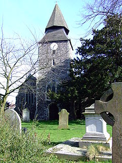
The church with unusual steeple
 Upchurch shown within Kent
OS grid reference TQ843675 District Swale Shire county Kent Region South East Country England Sovereign state United Kingdom Post town Sittingbourne Postcode district ME9 Dialling code 01634 Police Kent Fire Kent Ambulance South East Coast EU Parliament South East England UK Parliament Sittingbourne and Sheppey List of places: UK • England • Kent Upchurch village is situated at the junction of numerous minor roads in the Swale district of Kent, England. It is a civil parish within Swale Borough Council, and the village centre is about 1 mile (1.6 km) east of the boundary with the unitary authority of Medway.
History
Upchurch lay on a pre-Roman trackway; the many linking roads are the result of Roman occupation, which had built a community of ex-soldiers who wanted to settle in England. A Roman cemetery has been discovered here. There were also several Roman pottery works sited here. It is probable that, although today the land is low-lying and marshy, it was once higher than it is today.
The Upchurch Hoard is a hoard of well worn coins which date from the first and second century A.D. which were found close to Upchurch.[1] A more recent pottery was established here in 1909 called the Upchurch Pottery. Although it is now closed it became well known and could be found retailing through such outlets as Liberty & Co..
The village has a connection with Sir Francis Drake whose father became its vicar in 1560 after having been prayer-reader to the Medway fleet.[2]
Under the 14th century church is a small crypt (a charnel house) where bones were kept when the churchyard was full. It was discovered in 1877 and the bones re-interred. The church is also notable for its very unusual 'candle-snuffer' steeple where an octagonal pyramid appears to have been stacked on top of a square one resembling a couple of inverted ice-cream cones. It is believed that the distinctive shape was chosen to serve as a navigational aid for shipping on The River Thames.
The settlement of Otterham Quay lies a mile west of the village at the head of Otterham Creek.
Facilities
In the Village, there is a food store, a newsagent, a local chip shop, a post office, a hardware store and a Greengrocer. Upchurch also has a Cricket Club with a membership of 150 players. The club has developed into one of the finest cricketing facilities in Kent. They have developed a fine clubhouse,with two cricket squares and the first eleven has now risen into Division Three of the Kent League. They currently field 4 teams on a Saturday, two on a Sunday, and several youth teams.
References
- ^ Upchurch Hoard, Andrew McCabe, ancients.info, accessed June 2010
- ^ Notes on Upchurch
Categories:- Swale
- Villages in Kent
Wikimedia Foundation. 2010.


