- Murston
-
Coordinates: 51°20′28″N 0°45′09″E / 51.341°N 0.7524°E
Murston 
 Murston
Murston shown within KentPopulation 5,300 (2005)[1] District Swale Shire county Kent Region South East Country England Sovereign state United Kingdom Police Kent Fire Kent Ambulance South East Coast EU Parliament South East England List of places: UK • England • Kent Murston is a suburb of Sittingbourne in Kent, England.
Towns and villages in the Borough of Swale in Kent, England 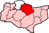 Bapchild · Badlesmere · Bay View · Bobbing · Borden · Boughton Street · Boughton under Blean · Bredgar · Brogdale · Buckland · Chestnut Street · Conyer · Dargate · Davington · Denstroude · Doddington · Dunkirk · Eastchurch · Eastling · Elmley · Faversham · Faversham Without · Goodnestone · Graveney · Halfway Houses · Hartlip · Harty · Heart's Delight, Swale · Hernhill · Highsted · Iwade · Kemsley · Keycol · Kingsdown · Leaveland · Leysdown-on-Sea · Lower Halstow · Luddenham · Lynsted · Milstead · Milton Regis · Minster · Mockbeggar · Murston · Newington · Newnham · Norton · Oad Street · Oare · Ospringe · Oversland · Painters Forstal · Queenborough · Rodmersham Green · Rushenden · Selling · Sheldwich · Shellness · Sheerness · Sittingbourne · Stalisfield Green · Teynham · Throwley · Tonge · Tunstall · Upchurch · Uplees · Warden · Waterham · Whitehill
List of places in Kent References
- ^ "2005 Ward Level Population Estimates". Kent County Council. September 2006. http://www.kent.gov.uk/NR/rdonlyres/E503169D-C06B-498F-BD0A-678EE22B4D37/6841/sae108.pdf. Retrieved 2007-08-20.
External links
 Media related to Murston at Wikimedia CommonsCategories:
- Swale
- Villages in Kent
- Kent geography stubs


Wikimedia Foundation. 2010.