- Dunkirk, Kent
-
Coordinates: 51°17′29″N 0°58′49″E / 51.2915°N 0.9804°E
Dunkirk 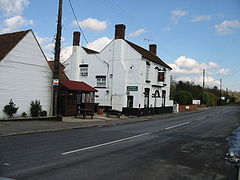
The Red Lion Inn, Dunkirk
 Dunkirk
Dunkirk shown within KentDistrict Swale Shire county Kent Region South East Country England Sovereign state United Kingdom Police Kent Fire Kent Ambulance South East Coast EU Parliament South East England UK Parliament Canterbury List of places: UK • England • Kent Dunkirk is a village and civil parish between Faversham and Canterbury in southeast England.
Toponymy
The origin of the village's name is still not very clear, but it is understood to come from a house called "Dunkirk", lived in by a Fleming from Dunkerque on the border between France and Belgium.
Dunkirk's main claim to fame is that in 1838 it was the scene of the last armed rising on British soil, the Battle of Bossenden Wood to the north of the village.
External links
 Media related to Dunkirk, Kent at Wikimedia Commons
Towns and villages in the Borough of Swale in Kent, England 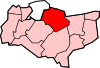 Bapchild · Badlesmere · Bay View · Bobbing · Borden · Boughton Street · Boughton under Blean · Bredgar · Brogdale · Buckland · Chestnut Street · Conyer · Dargate · Davington · Denstroude · Doddington · Dunkirk · Eastchurch · Eastling · Elmley · Faversham · Faversham Without · Goodnestone · Graveney · Halfway Houses · Hartlip · Harty · Heart's Delight, Swale · Hernhill · Highsted · Iwade · Kemsley · Keycol · Kingsdown · Leaveland · Leysdown-on-Sea · Lower Halstow · Luddenham · Lynsted · Milstead · Milton Regis · Minster · Mockbeggar · Murston · Newington · Newnham · Norton · Oad Street · Oare · Ospringe · Oversland · Painters Forstal · Queenborough · Rodmersham Green · Rushenden · Selling · Sheldwich · Shellness · Sheerness · Sittingbourne · Stalisfield Green · Teynham · Throwley · Tonge · Tunstall · Upchurch · Uplees · Warden · Waterham · Whitehill
List of places in Kent Categories:- Swale
- Villages in Kent
- Kent geography stubs


Wikimedia Foundation. 2010.