- Denstroude
-
Coordinates: 51°18′56″N 1°01′12″E / 51.31557°N 1.020°E
Denstroude 
 Denstroude
Denstroude shown within KentDistrict Swale Shire county Kent Region South East Country England Sovereign state United Kingdom Post town Canterbury Police Kent Fire Kent Ambulance South East Coast EU Parliament South East England List of places: UK • England • Kent Denstroude is a dispersed hamlet located to the west of the A290 road north of Canterbury in Kent, England. It is a collection of houses and farms, one of which takes its name from the hamlet; the other being Parsonage Farm, although there is no church nearby. It stretches between the parishes of Blean and Dunkirk, in the districts of Canterbury and Swale respectively.
External links
 Media related to Denstroude at Wikimedia Commons
Towns and villages in the Borough of Swale in Kent, England 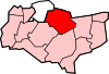 Bapchild · Badlesmere · Bay View · Bobbing · Borden · Boughton Street · Boughton under Blean · Bredgar · Brogdale · Buckland · Chestnut Street · Conyer · Dargate · Davington · Denstroude · Doddington · Dunkirk · Eastchurch · Eastling · Elmley · Faversham · Faversham Without · Goodnestone · Graveney · Halfway Houses · Hartlip · Harty · Heart's Delight, Swale · Hernhill · Highsted · Iwade · Kemsley · Keycol · Kingsdown · Leaveland · Leysdown-on-Sea · Lower Halstow · Luddenham · Lynsted · Milstead · Milton Regis · Minster · Mockbeggar · Murston · Newington · Newnham · Norton · Oad Street · Oare · Ospringe · Oversland · Painters Forstal · Queenborough · Rodmersham Green · Rushenden · Selling · Sheldwich · Shellness · Sheerness · Sittingbourne · Stalisfield Green · Teynham · Throwley · Tonge · Tunstall · Upchurch · Uplees · Warden · Waterham · WhitehillCategories:
- Swale
- Villages in Kent
- Kent geography stubs


Wikimedia Foundation. 2010.