- Crowsnest Highway
-
Crowsnest Highway

Highway 3 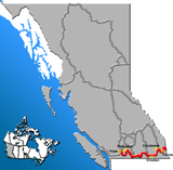
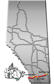
Route information Length: 1,161 km (721 mi) Existed: 1932 – present Major junctions West end:  BC 1 near Hope, BC
East end: 
 Hwy 1 / Hwy 41A in Medicine Hat, AB
Location Municipalities: Hope, Sparwood, Crowsnest Pass Rural municipalities: Pincher Creek No. 9 M.D., Willow Creek No. 26 M.D., Lethbridge County, Taber M.D., Forty Mile No. 8 County, Cypress County Major cities: Greenwood, Grand Forks, Castlegar, Cranbrook, Fernie, Lethbridge, Medicine Hat Towns: Princeton, Osoyoos, Creston, Fort Macleod, Coalhurst, Coaldale, Taber, Bow Island Villages: Keremeos, Midway, Salmo, Cowley, Barnwell Highway system Trans-Canada Highway
Provincial highways in British ColumbiaProvincial highways in Alberta
←  BC 2
BC 2BC BC 3A  →
→←  Hwy 2A
AB Hwy 3A  →
→The Crowsnest Highway, also known as the Interprovincial or, in British Columbia, the Southern Trans-Provincial, is an east-west highway, 1,161 km (721 mi) in length, through the southern parts of British Columbia and Alberta, providing the shortest highway connection between British Columbia's Lower Mainland and southeast Alberta. It is designated a core route in Canada's National Highway System,[1] and is designated as Highway 3 for its entire length.
The highway, which is mostly two lanes, was officially established in 1932, mainly following a mid-19th century gold rush trail originally traced out by an engineer named Edgar Dewdney. It takes its name from the Crowsnest Pass, the location at which the highway crosses the Continental Divide between British Columbia and Alberta.
In British Columbia, the first segment of the highway between the Trans-Canada Highway and Highway 5A is locally known as the Hope-Princeton Highway. In Alberta, the highway forms concurrencies with both the Red Coat Trail and the CANAMEX Corridor from Highway 2 west of Fort Macleod to Highway 4 at the eastern limits of Lethbridge.
Contents
Route description
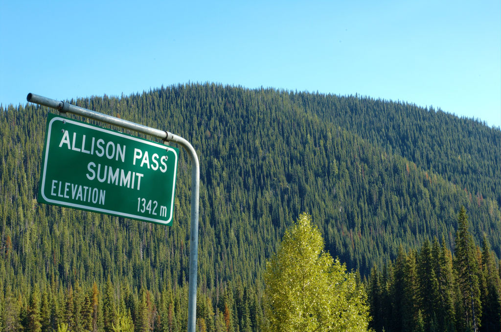
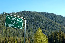 The peak of Allison Pass.
British Columbia
The Crowsnest Highway's total length in British Columbia is 837 km (520 mi),[citation needed] and its total length within Alberta is 324 km (201 mi).[2] The Crowsnest Highway's western terminus is at Hope, where it branches off from Highway 1. The highway goes east for 7 km (4.3 mi) to its junction with Highway 5, then through Allison Pass and Manning Provincial Park for 127 km (79 mi) towards the Town of Princeton. There are several significant ascents in this stretch between Hope and Princeton. The first is the steep climb to the Hope Slide, followed later by the remainder of the climb up to Allison Pass at an elevation of 1,342m (4,473 ft). After the summit of Allison Pass, the road descends for 40 km (25 mi) before beginning another long climb up Sunday Summit (1,284m, 4,280 ft). Soon after Sunday Summit is the descent into Princeton, where Highway 5A begins.
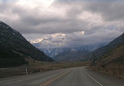 Through the Similkameen Valley westwards into the mountains
After Princeton, the Crowsnest goes southeast for 67 km (42 mi), through Hedley, to the Village of Keremeos, where a junction with a length of highway designated as 3A is located, leading towards Penticton and Highway 97. Another 46 km (29 mi) southeast, and the Crowsnest reaches the Town of Osoyoos and a junction with Highway 97. The highway then proceeds to hug the Canada-U.S. border east through a stretch of switchbacks known as Anarchist Mountain, which is also the name of the upland rural community beyond the summit.
52 km (32 mi) east of Osoyoos, the Crowsnest reaches its junction with Highway 33 at Rock Creek, then the highway heads east for 70 km (43 mi) to its junction with Highway 41 at a location called Carson, just west of Grand Forks. Another 26 km (16 mi) east, passing through Grand Forks en route, the Crowsnest meets Highway 395 at the southern end of Christina Lake.
Further east from Christina Lake, the Crowsnest travels for 47 km (29 mi) through Bonanza Pass to its junction with Highway 3B at Nancy Greene Lake, which is the cutoff to the ski town of Rossland. It is another 26 km (16 mi) east to the junction with Highway 22 at Castlegar, and another 2 km (1.2 mi) east to a junction with another stretch of Highway designated as 3A, also within Castlegar. Leaving Castlegar, the Crowsnest reaches its eastern junction with Highway 3B 26 km (16 mi) east. Highway 6 converges with the Crowsnest at Salmo, 11 km (6.8 mi) east of the 3B junction, and the two highways proceed south for 14 km (8.7 mi) to the Burnt Flat Junction, where Highway 6 diverges south.
East of Burnt Flat, the Crowsnest heads through the Kootenay Pass on a stretch known as the Kootenay Skyway, or Salmo-Creston Skyway. 67 km (42 mi) east of Burnt Flat, the Crowsnest reaches the Town of Creston, just past junctions with Highway 21 and Highway 3A. 40 km (25 mi) later, south of Yahk, Highway 95 merges onto the Crowsnest. The two highways share a common alignment for 72 km (45 mi) northeast along the Moyie River to a junction with Highway 95A at Cranbrook. Another 6 km (3.7 mi) east, Highway 95 diverges north from the Crowsnest and Highway 93 merges onto the Crowsnest from the north. Highway 93 and the Crowsnest share a common alignment for the next 53 km (33 mi) southeast to Elko, where Highway 93 diverges south. 31 km (19 mi) north of Elko, the Crowsnest reaches Fernie, then it goes north another 30 km (19 mi) to its junction with Highway 43 at Sparwood, and another 19 km (12 mi) east, the highway reaches the boundary with Alberta at Crowsnest Pass.
Alberta
Once into Alberta, the Crowsnest Highway goes east 16 km (9.9 mi) to the Bighorn Highway at Coleman, then 26 km (16 mi) east to its junction with Highway 22, another 20 km (12 mi) to its junction with Highway 6, then another 44 km (27 mi) to its junction with Highway 2 north, then proceeding 5 km (3.1 mi) east into the Town of Fort Macleod and the Crowsnest's junction with Highway 2 south. After Fort Macleod, the Crowsnest goes 27 km (17 mi) east, crossing the Oldman River, to Highway 3A southeast of Monarch, which feeds Highway 23.
The highway reaches the first access (Westview Drive W) to the City of Lethbridge 13 km (8.1 mi) later. At this point, the Crowsnest's only freeway segment begins. 2 km (1.2 mi) later, Highway 25 (University Drive W) branches to the north before crossing the Oldman River for the second time. The freeway segment ends at Mayor Magrath Drive, which branches as Highway 5 to the south. The highway intersects Highway 4 at the eastern limits of Lethbridge.
45 km (28 mi) east of Lethbridge, the Crowsnest reaches the Town of Taber. Within Taber, Highway 36 runs concurrently with the highway for 3 km (1.9 mi). Upon dropping the concurrency, the Crowsnest ends 113 km (70 mi) later at the Trans-Canada Highway in the City of Medicine Hat.
Major intersections
British Columbia
The following is a list of exits along the expressway and freeway portions of British Columbia Highway 3 (Crowsnest Highway).
Hope to Princeton

District Municipality km Exit Destinations Notes 170 BC 1 north, Water AvenueEastbound only 171 3 Avenue Westbound only 173 Old Hope- Princeton Way 177  BC 5 Coquihalla Highway, Highway 3, Crowsnest Highway
1.000 mi = 1.609 km; 1.000 km = 0.621 mi
Concurrency terminus • Closed/Former • Incomplete access • UnopenedCastlegar
District Municipality km Exit Destinations Notes  BC 22 south (Columbia Ave.) – Rossland, Trail
20th St., 6th Ave. to BC 22Westbound only BC 3A east – Castlegar Airport, Nelson1.000 mi = 1.609 km; 1.000 km = 0.621 mi
Concurrency terminus • Closed/Former • Incomplete access • UnopenedCranbrook
District Municipality km Exit Destinations Notes Begin expressway at 22nd Street north 23rd Street N At-grade intersection 30th Street N At-grade intersection  BC 95A north – Cranbrook Airport, Kimberley
 BC 95 / BC 93 north – Fort Steele, Invermere, Radium Hot Springs
Begin multiplex with Highway 93 Expressway ends 1.000 mi = 1.609 km; 1.000 km = 0.621 mi
Concurrency terminus • Closed/Former • Incomplete access • UnopenedAlberta

The following is a list of major intersections along Alberta Highway 3 (Crowsnest Highway) from west to east.[2][3]
Municipality km Description Notes Municipality of Crowsnest Pass 0 Begins at British Columbia border
Preceded by BC 3
BC 316  Hwy 40 branches off to the north at Coleman
M.D. of Pincher Creek No. 9 35  Hwy 507 branches off to the south near Burmis
40  Hwy 3A branches off to the southeast
42  Hwy 22 branches off to the north
43 Hwy 3A branches off to the southwest near LundbreckVillage of Cowley 52  Hwy 510 branches off to the north
M.D. of Pincher Creek No. 9 62  Hwy 6 branches off to the south at Pincher Station
65 Crosses  Hwy 785
77  Hwy 786 branches off to the south at Brocket
M.D. of Willow Creek No. 26 105  Hwy 810 branches off to the south
106  Hwy 2 branches off to the north
Hwy 2 concurrency beginsInterchange (Exit 89 on Hwy 2)
 Red Coat Trail concurrency begins
CANAMEX Corridor concurrency beginsTown of Fort Macleod 110  Hwy 811 branches off to the north
111 Hwy 2 branches off to the south
Hwy 2 concurrency endsM.D. of Willow Creek No. 26 132 Hwy 3A branches off to the northeastCounty of Lethbridge Crosses the Oldman River 138 Hwy 3A branches off to the northwest to  Hwy 23
Partial interchange 145  Hwy 509 branches off to the south
UAR 205 branches off to the north at Kipp near CoalhurstCity of Lethbridge 151 Hwy 3A (Westside Drive W) branches off to the southeastPartial interchange 153  Hwy 25 branches off to the north
University Drive W branches off to the southInterchange 155 Bridge Drive W (former Hwy 3A) branches off to the southInterchange Crosses the Oldman River 155.5 Crosses an unnamed road in the Oldman River valley Interchange 156 5 Avenue N branches off to the east Partial interchange 156.5 1 Avenue S branches off to the south Eastbound exit only 157 Crosses Scenic Drive Partial interchange 158 Crosses Stafford Drive Interchange 159 Crosses 13 Street Grade-separated, westbound exit only 160 Crosses Mayor Magrath Drive
 Hwy 5 branches off to the south
Interchange 161.5  Hwy 512 (1 Avenue S) branches off to the east
Eastbound exit only 162 Crosses 43 Street
 Hwy 4 branches off to the south
 Hwy 843 branches off to the north Red Coat Trail concurrency ends
CANAMEX Corridor concurrency endsTown of Coaldale 174 Crosses  Hwy 845
County of Lethbridge 184 Hwy 512 branches off to the southM.D. of Taber 199 Hwy 3A branches off to the northeast to Barnwell202 Hwy 3A branches off to the northwest to BarnwellTown of Taber 207  Hwy 864 branches off to the north
208  Hwy 36 branches off to the south
Hwy 36 concurrency begins211 Hwy 36 branches off to the north
Hwy 36 concurrency endsM.D. of Taber 242  Hwy 877 branches off to the south at Grassy Lake
County of Forty Mile No. 8 260 Crosses  Hwy 879 between Burdett and Bow Island
286  Hwy 885 branches off to the south
Cypress County 302  Hwy 887 branches off to the south near Seven Persons
City of Medicine Hat 321  Hwy 523 (Holsom Road SW) branches off to the west
324 Ends at Hwy 1
Succeeded by Hwy 41AInterchange 1.000 mi = 1.609 km; 1.000 km = 0.621 mi
Concurrency terminus • Closed/Former • Incomplete access • UnopenedSee also
- Dewdney Trail
- Kettle Valley Railway (southern mainline of the CPR)
References
- ^ "National Highway System". Transport Canada. 2009-12-13. http://www.tc.gc.ca/eng/mediaroom/backgrounders-b05-r003e-1877.htm. Retrieved 2011-03-16.
- ^ a b "2010 Provincial Highways 1 - 216 Series Progress Chart". Alberta Transportation. March 2010. http://www.transportation.alberta.ca/Content/docType329/Production/provincial001-216.pdf. Retrieved 2011-03-16.
- ^ Alberta Tourism, Parks and Recreation. Alberta Official Road Map (Map) (2010 ed.). Section N-5, N–6, N-7, N–8.
External links
- Crowsnest Highway tour
- 2010 Provincial Highways 1 - 216 Series Progress Chart (map, 8 MB) by Alberta Transportation.
Roads of British Columbia Provincial highways 1 · 1A · 2 · 3 · 3A · 3B · 4 · 4A · 5 · 5A · 6 · 7 · 7B · 8 · 9 · 10 · 11 · 12 · 13 · 14 · 15 · 16 · 17 · 18 · 19 · 19A · 20 · 21 · 22 · 22A · 23 · 24 · 26 · 27 · 28 · 29 · 30 · 31 · 31A · 33 · 35 · 37 · 37A · 39 · 41 · 43 · 49 · 52 · 77 · 91 · 91A · 93 · 95 · 95A · 97 (A · B · C · D) · 99 · 101 · 113 · 118 · 395 · South Fraser Perimeter Road (under construction)Other provincially maintained roads Atlin Road · Bridge River Road · Cecil Lake Road · Coalmont Road · Cultus Lake Road · Glover Road · Head Bay Road · Hemlock Valley Road · Horsefly Road · Jesmond Road · Likely Road · Mission Mountain Road · Nazko Road · Omineca Resource Road · Pavilion Mountain Road · Port Mellon Highway · Queen Charlotte City-Skidegate Road · Strathcona Parkway · Telegraph Creek Road · Westside RoadHistorical provincial highways Municipal limited-access roads Barnet Highway · Gaglardi Way · Golden Ears Way · Grant McConachie Way · Knight Street · SW Marine Drive · Marine Way · Russ Baker WayHistoric roads and trails Alaska Highway · Atlin Road · Cariboo Road · Chilkoot Trail · Crowsnest Highway · Dewdney Trail · Dewdney Trunk Road · Douglas Road · Hudson's Bay Brigade Trail · Lillooet Cattle Trail · Nisga'a Highway · Okanagan Trail · Old Cariboo Road · Old Yale Road (Grand Trunk Road) · River Trail · Whatcom TrailSee also Italics denotes highways with expressway sections.
Bold denotes highways with expressway and freeway sections.Highways in Alberta 
Expressways
and FreewaysNamed
HighwaysAnthony Henday · Bicentennial · Bighorn · Bow Valley Parkway · Bow Valley Trail · Buffalo · Cowboy · Crowsnest · David Thompson · Devonian Way · Dinosaur · Forestry Trunk · Grizzly · Hoo Doo Trail · Icefields Parkway · Mackenzie · Northern Woods and Water Route · Parkland · Poundmaker · Queen Elizabeth II · Red Coat Trail · Sherwood Park Freeway · Stoney · Trans-Canada · Veterans Memorial · Yellowhead1-216 Series 1 · 1A · 1X · 2 · 2A · 3 · 3A · 4 · 5 · 6 · 7 · 8 · 9 · 10 · 10X · 11 · 11A · 12 · 13 · 13A · 14 · 15 · 16 · 16A · 17 · 18 · 19 · 20 · 20A · 21 · 22 · 22X · 23 · 24 · 25 · 26 · 27 · 28 · 28A · 29 · 31 · 32 · 33 · 35 · 36 · 37 · 38 · 39 · 40 · 41 · 41A · 42 · 43 · 44 · 45 · 47 · 49 · 50 · 52 · 53 · 54 · 55 · 56 · 58 · 59 · 60 · 61 · 62 · 63 · 64 · 64A · 66 · 68 · 69 · 72 · 88 · 93 · 93A · 100 · 201 · 216Categories:- Alberta Primary Highways, 1-216 series
- Freeways in Alberta
- British Columbia provincial highways
- Trans-Canada Highway
- Interior of British Columbia


Wikimedia Foundation. 2010.