- Memorial Drive (Calgary)
-
Memorial Drive 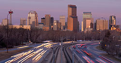
Memorial Drive seen from the Zoo bridgeMaintained by: City of Calgary Length: 14 km (9 mi) Location: Calgary Major
junctions:Deerfoot Trail Memorial Drive (formerly Sunnyside Boulevard) is a major road in Calgary, Alberta. Besides having an important role in city infrastructure, the tree lined sides of Memorial Drive serve as a living testament to the many soldiers who died during World War I and give it a parkway look on the western section.[1] An active path system also runs along the south side of Memorial Drive, beside the banks of the Bow River. The Calgary Soldiers' Memorial will form part of an extensive renovation to Memorial Drive, which will heighten the function of the road as a monument to the city's military.[2] The Landscape of Memory Project began in 2004, in order to revitalize a nine kilometre stretch of the road. [3]
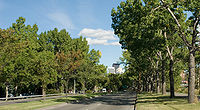 Memorial Drive looking east from 17 St NW
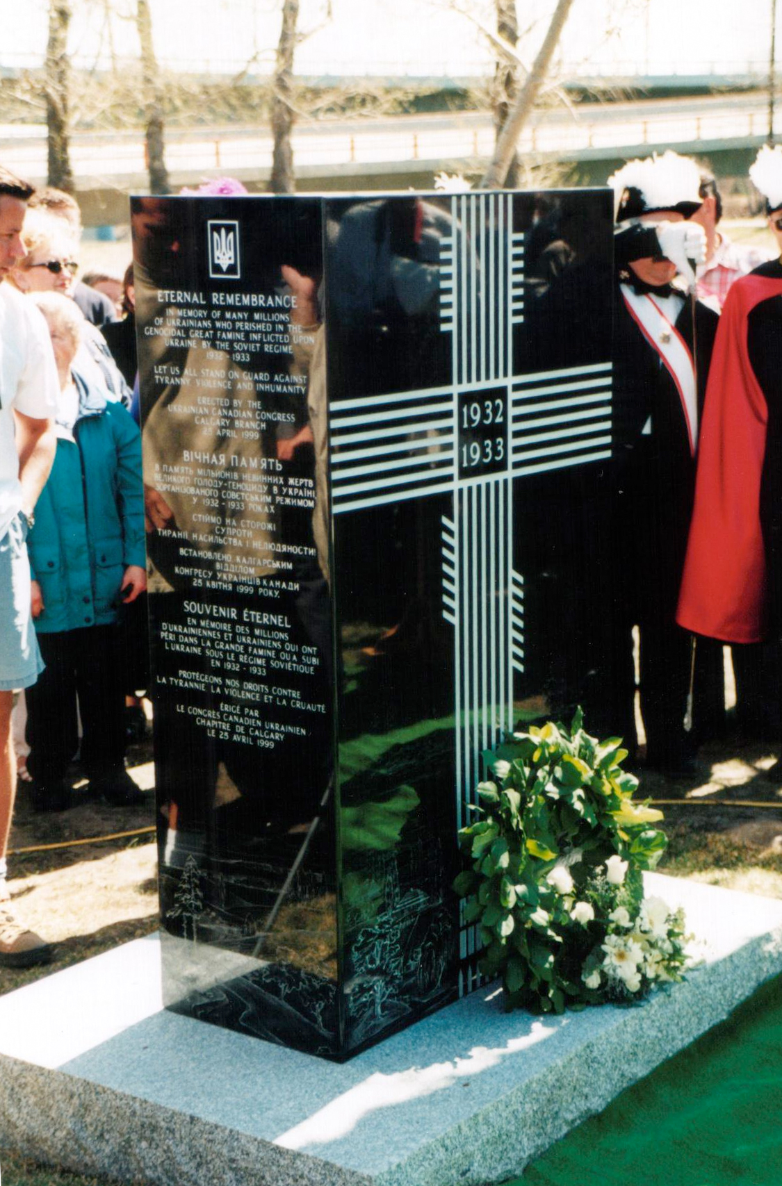
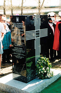 Ihor Novosilets' Holodomor Monument near Memorial Drive (Calgary) at Edmonton Trail, Dedication: "Eternal Remembrance. In memory of many millions of Ukrainians who perished in the genocidal great famine inflicted upon Ukraine by the Soviet Regime 1932-1933. Let us all stand on guard against tyranny, violence and inhumanity."
Memorial Drive officially begins at an interchange with Crowchild Trail in the northwest, serving as an eastern extension of Parkdale Boulevard (which, along with 3 Avenue NW, is an extension of the arterial connector Bowness Road). The road continues east as a divided parkway until it passes the dual-intersection with 4th Street NE and Edmonton Trail at which point it becomes a freeway until Deerfoot Trail (at which point it downgrades to an at-grade expressway). (Westbound traffic is offered a flyover into downtown at the 4th/Edmonton intersection. At this point the C-Train runs along the median of the split road, beginning with the Bridgeland/Memorial Station. After passing Barlow Trail, the road downgrades to a major arterial with the C-Train turning north along 36th Street/Metis Trail after the Franklin Station. Memorial is then downgraded to traffic signalized intersections and continues east to 68th Street N.E., where it downgrades once again to a residential street for its last few blocks to its present terminus at Abbeydale Drive.
City planners have made provisions for Memorial Drive to eventually connect with the proposed East Freeway. East of 36th Street[4], Memorial Drive serves as the boundary between the Northeast and Southeast sectors of the city.
Major intersections
From west to east, the following intersections[5] are observed along Memorial Drive:
Memorial Drive Exit list 
Entering the City of Calgary 
Continues as Parkdale Boulevard, 3 Avenue NW, and Bowness Road to Highway 1 - Trans-Canada Highway 

Kensington Road to Crowchild Trail At-grade intersection 

km 0 Crowchild Trail No access to Crowchild Trail SB, Crowchild NB from Memorial EB, or Memorial WB from Crowchild SB from this exit; use Kensington Road 
19th Street W No access to 19th Street from Memorial EB, use Kensington Road 
km 1.5 14th Street W EB exit to SB 14th Street and NB exit from 14th Street to Memorial WB only; all other access use Kensington Road 

km 2.2 10 Street W to Kensington Avenue - Becomes local arterial road past this point At-grade intersection 
km 4.2 Lower deck of Centre Street Bridge At-grade intersection 


km 5.0 4th Street to Downtown Calgary At-grade intersection; although left turns are permitted from WB Memorial, much traffic to Downtown Calgary uses 4th Street Flyover 

km 5.1 Edmonton Trail from Downtown Calgary At-grade intersection, much traffic uses yield lane onto Memorial EB 

km 5.2 4th Street Flyover to Downtown Calgary Becomes freeway past this point, speed changes to 80 km/h 
9th Street E WB right-in, right-out 
km 6.2 12th Street E, Zoo Road to Calgary Zoo, Zoo C-Train Station km 7.5 Highway 2 - Deerfoot Trail Intersections on Memorial at interchange, downgrades to expressway past this point 19th Street E WB right-in, right-out km 8.7 Barlow Trail km 9.6 28th Street E At-grade intersection, speed changes to 60 km/h km 10.3 36th Street E At-grade intersection 39th Street E, Marlborough Way - Becomes local arterial road past this point At-grade intersection km 12.2 52nd Street E At-grade intersection km 13.7 68th Street E At-grade intersection km 14.0 Ends at Abbeyvale Drive At-grade intersection 
Proposed extension to East Freeway See also
References
- ^ City of Calgary. The Trees of Memorial Drive
- ^ City of Calgary revitalization plan for Memorial Drive
- ^ Calgary Sun article
- ^ City of Calgary. Memorial Drive Project
- ^ "Memorial Drive on Alberta Roads". Photographed July 2002. http://albertaroads.homestead.com/Calgary/memorial.html. Retrieved 7 September 2009.
Roads in Calgary, Alberta North-south routes Nose Hill Drive • Sarcee Trail • Shaganappi Trail • Crowchild Trail · Centre Street · Macleod Trail · Edmonton Trail • Blackfoot Trail • Deerfoot Trail • Barlow Trail • Metis Trail • 52 Street EEast-west routes Country Hills Boulevard • Beddington Trail • Airport Trail • McKnight Boulevard • John Laurie Boulevard • Memorial Drive • Bow Trail • 17 Avenue SW • 17 Avenue SE • Heritage Drive • Southland Drive • Anderson Road • Canyon Meadows DriveHighways and expressways 1 (16 Avenue N) · 1A (Crowchild Trail) · 2 (Deerfoot Trail) · 2A (Macleod Trail) · 8 (Glenmore Trail) · 22X (Marquis of Lorne Trail) · 201 (Stoney Trail) • 560 (Glenmore Trail) • 563 (Old Banff Coach Road) • 772 (Symons Valley Road) • 773 (37 Street SW)Highways in Alberta 
Expressways
and FreewaysNamed
HighwaysAnthony Henday · Bicentennial · Bighorn · Bow Valley Parkway · Bow Valley Trail · Buffalo · Cowboy · Crowsnest · David Thompson · Devonian Way · Dinosaur · Forestry Trunk · Grizzly · Hoo Doo Trail · Icefields Parkway · Mackenzie · Northern Woods and Water Route · Parkland · Poundmaker · Queen Elizabeth II · Red Coat Trail · Sherwood Park Freeway · Stoney · Trans-Canada · Veterans Memorial · Yellowhead1-216 Series 1 · 1A · 1X · 2 · 2A · 3 · 3A · 4 · 5 · 6 · 7 · 8 · 9 · 10 · 10X · 11 · 11A · 12 · 13 · 13A · 14 · 15 · 16 · 16A · 17 · 18 · 19 · 20 · 20A · 21 · 22 · 22X · 23 · 24 · 25 · 26 · 27 · 28 · 28A · 29 · 31 · 32 · 33 · 35 · 36 · 37 · 38 · 39 · 40 · 41 · 41A · 42 · 43 · 44 · 45 · 47 · 49 · 50 · 52 · 53 · 54 · 55 · 56 · 58 · 59 · 60 · 61 · 62 · 63 · 64 · 64A · 66 · 68 · 69 · 72 · 88 · 93 · 93A · 100 · 201 · 216Categories:- Freeways in Alberta
- Roads in Calgary

Wikimedia Foundation. 2010.