- Crowchild Trail
-
Crowchild Trail 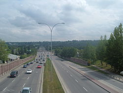
Crowchild Trail, just north of 5 Ave NW looking SouthLocation: Calgary, Alberta Crowchild Trail is an expressway located on the west side of Calgary, Alberta, Canada.
The road was originally signed as 24th Street SW from North Glenmore Park to the Bow River, 24th Street NW from the Bow to the intersection with 16th Avenue NW (the Trans-Canada Highway, Highway 1), and Highway 1A from 16th Ave NW to the city limits. It was renamed Crowchild Trail in March, 1971 in honour of David Crowchild, Chief of the Tsuu T'ina Nation from 1946 to 1953.
Crowchild Trail's south terminus is located at North Glenmore Park as a minor arterial road. Exiting northbound from the park the road intersects several residential streets within the communities of Lakeview and North Glenmore Park, and several residential dwellings are located on the Trail itself. Continuing northward, its first major intersection is with Glenmore Trail at an interchange that was built in 1981, which is the point at which Crowchild becomes an freeway. After an interchange was completed at 50th Avenue SW in 2003, Crowchild Trail became a true freeway from Glenmore Trail to Kensington Road NW, with overpasses at Flanders Avenue SW, 33rd Avenue SW and 17th Avenue SW and interchange intersections with 10th Avenue SW, Bow Trail and Memorial Drive. The speed limit on the freeway sections are 80 km/h (50 mph).
Traffic slows immediately north of the Bow River (dropping to a principal arterial with a 60 km/h (40 mph) limit), with controlled intersections at Kensington Road NW and 5th Avenue NW, and heavy use by football fans and transit users at McMahon Stadium and students of the University of Calgary. After 24th Avenue NW the road veers northwest, and once again becomes an uninterrupted freeway until the Stoney Trail ring road. An interchange is currently under construction at Stoney Trail, which will make Crowchild Trail a freeway nearly to the city limits, at which point (following a signalized intersection with Twelve Mile Coulee Road), Crowchild Trail continues as Highway 1A, eventually linking to the towns of Cochrane and Canmore.
Contents
Major intersections
From south to north, the following intersections[1] are observed along Crowchild Trail:
Crowchild Trail Exit list 
Entering the City of Calgary 
Starts north of Glenmore Reservoir as a minor arterial road 


 km 1.0
Highway 8 - Glenmore Trail At-grade intersections on Crowchild Trail; Becomes freeway, speed limit changes to 80 km/h 

Southbound flyover to Glenmore Trail westbound 
km 1.6 54th Avenue SW Right-in, right-out on northbound lanes only km 2.1 50th Avenue SW, Mt. Royal Gate SW km 3.0 Flanders Avenue, Caen Avenue, Richard Road km 3.9 33rd Avenue SW 
km 4.5 24th Street SW to 17th Avenue SW Southbound lanes only km 4.6 Richmond Road, 17th Avenue SW Northbound lanes only 

km 6.2 Bow Trail No access from Bow Trail eastbound to Crowchild Trail southbound, and from Crowchild Trail northbound to Bow Trail westbound 

km 6.4 10th Avenue SW SB exit, NB entrance only; Bow Trail westbound uses 10th Avenue SW to access Crowchild Trail northbound 
km 6.9 Bow River bridge 

km 7.0 Memorial Drive Access between Memorial and Crowchild limited; Use Kensington Road for most access 
 km 7.3
Kensington Road At-grade intersection, becomes expressway 
km 7.5 2nd Avenue NW Right-in, right-out on Northbound lanes only km 7.95th Avenue NW At-grade intersection 

km 8.5 University Drive to Trans-Canada Highway, University of Calgary Northbound exit, Southbound entrance 
 km 8.8
13th Avenue NW SB exit, intersects with University Drive 

km 9.0 Highway 1 - Trans-Canada Highway EB to Calgary, Medicine Hat and WB to Banff SB exit on Crowchild Trail only;Use University Drive exit to access from NB lanes 

McMahon Stadium access road At-grade intersection  km 9.5
23rd Avenue NW east to Banff Trail, west to McMahon Stadium Another access route to Highway 1; At-grade intersection 

km 9.6 Northbound entrance from Banff Trail, Highway 1A merges onto Crowchild Trail; Southbound access route to McMahon Stadium NB entrance only; use 23rd Avenue for primary access to Banff Trail  km 9.9
24th Avenue NW At-grade intersection; becomes freeway again km 11.0 Charleswood Drive 
km 11.3 Brentwood Road to Brentwood Village Mall Northbound exit only 

km 11.9 Southbound collector lane merges SB entrance 
 km 11.8
Brisebois Drive 


Northbound splits into express/collector setup, exits for Northland/Shaganappi or Brisebois Drive/Brentwood Road 


Brisebois Drive to northbound Crowchild on-ramp crosses collector lanes; Southbound exit to Brisebois Drive km 12.6Northland Drive 


km 12.9 Southbound collector lanes exit to Northland Mall, southbound Express to collector lanes exit; Northbound collector to express lanes km 13.3Shaganappi Trail 
km 13.4 Collector lanes merge onto main lanes 

km 14.4 Northbound right-in, right-out to Dalhousie Drive via 53rd Street exit km 14.653rd Street NW km 15.7 Sarcee Trail km 17.7 Nose Hill Drive Crowfoot Crescent km 18.3 Crowfoot Rise/Crowfoot Connector Right-in, right-out on NB lanes only km 19.7 Highway 201 - Stoney Trail km 22.312 Mile Coulee Road At-grade intersection; Freeway ends 
km 22.4 Exiting the City of Calgary 
Continues north-west as Highway 1A towards Cochrane Note:
Exits highlighted with yellow are proposed
Exits highlighted with blue are under construction
Exits highlighted with red are slated to be closedGallery
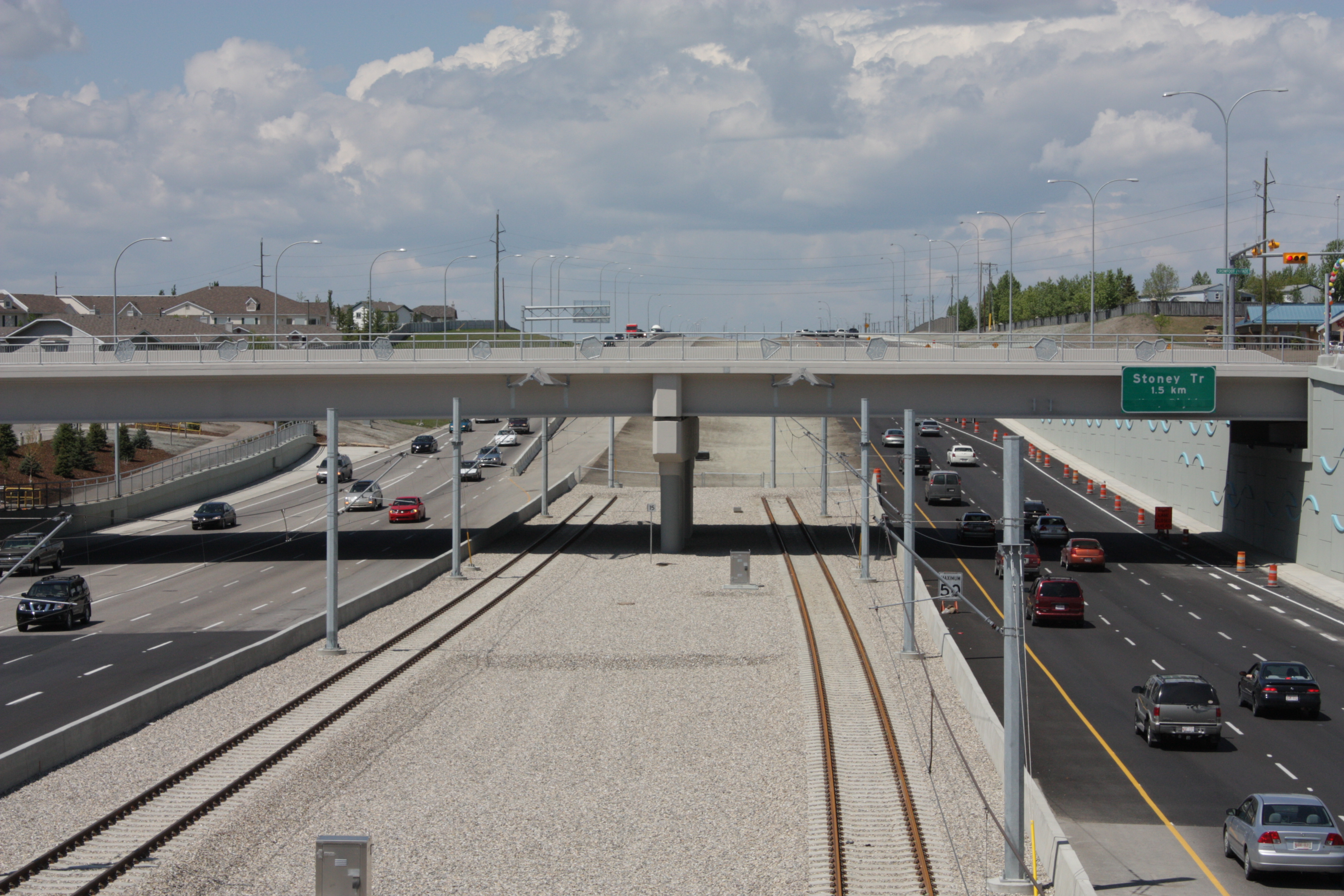
-

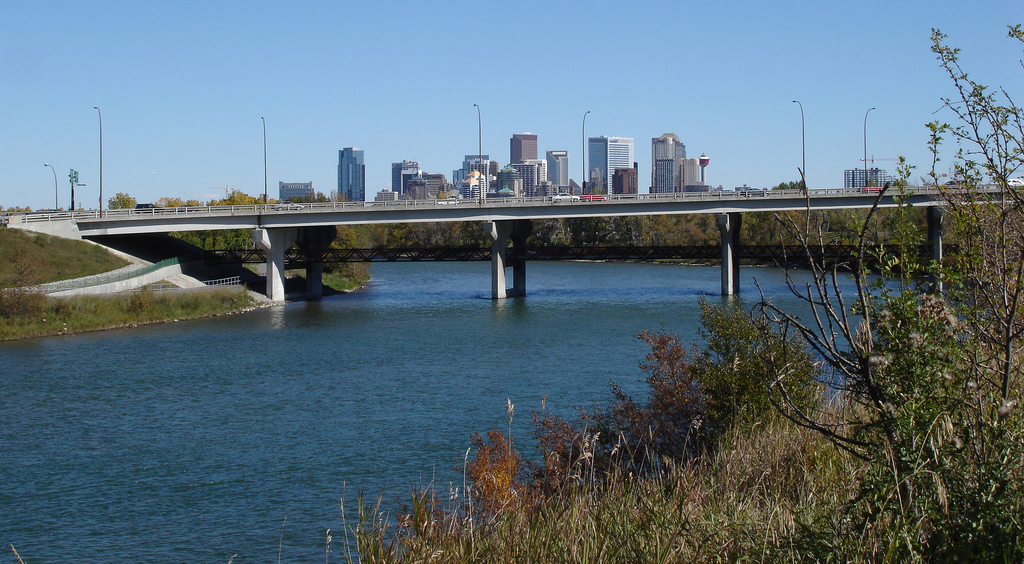
Crowchild Trail at the interchange with Stoney Trail
-
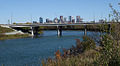
Bridge over Bow River
-
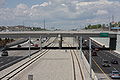
C-Train tracks along Crowchild Trail
References
- ^ "Crowchild Trail on Alberta Roads". Photographed August 2003. http://albertaroads.homestead.com/Calgary/Crowchild/crow1.html. Retrieved 7 September 2009.
See also
Roads in Calgary, Alberta North-south routes Nose Hill Drive • Sarcee Trail • Shaganappi Trail • Crowchild Trail · Centre Street · Macleod Trail · Edmonton Trail • Blackfoot Trail • Deerfoot Trail • Barlow Trail • Metis Trail • 52 Street EEast-west routes Country Hills Boulevard • Beddington Trail • Airport Trail • McKnight Boulevard • John Laurie Boulevard • Memorial Drive • Bow Trail • 17 Avenue SW • 17 Avenue SE • Heritage Drive • Southland Drive • Anderson Road • Canyon Meadows DriveHighways and expressways 1 (16 Avenue N) · 1A (Crowchild Trail) · 2 (Deerfoot Trail) · 2A (Macleod Trail) · 8 (Glenmore Trail) · 22X (Marquis of Lorne Trail) · 201 (Stoney Trail) • 560 (Glenmore Trail) • 563 (Old Banff Coach Road) • 772 (Symons Valley Road) • 773 (37 Street SW)Highways in Alberta 
Expressways
and FreewaysNamed
HighwaysAnthony Henday · Bicentennial · Bighorn · Bow Valley Parkway · Bow Valley Trail · Buffalo · Cowboy · Crowsnest · David Thompson · Devonian Way · Dinosaur · Forestry Trunk · Grizzly · Hoo Doo Trail · Icefields Parkway · Mackenzie · Northern Woods and Water Route · Parkland · Poundmaker · Queen Elizabeth II · Red Coat Trail · Sherwood Park Freeway · Stoney · Trans-Canada · Veterans Memorial · Yellowhead1-216 Series 1 · 1A · 1X · 2 · 2A · 3 · 3A · 4 · 5 · 6 · 7 · 8 · 9 · 10 · 10X · 11 · 11A · 12 · 13 · 13A · 14 · 15 · 16 · 16A · 17 · 18 · 19 · 20 · 20A · 21 · 22 · 22X · 23 · 24 · 25 · 26 · 27 · 28 · 28A · 29 · 31 · 32 · 33 · 35 · 36 · 37 · 38 · 39 · 40 · 41 · 41A · 42 · 43 · 44 · 45 · 47 · 49 · 50 · 52 · 53 · 54 · 55 · 56 · 58 · 59 · 60 · 61 · 62 · 63 · 64 · 64A · 66 · 68 · 69 · 72 · 88 · 93 · 93A · 100 · 201 · 216Categories:- Freeways in Alberta
- Roads in Calgary
- Alberta road stubs
- Calgary stubs
-


Wikimedia Foundation. 2010.