- C-Train
-
- This article is about the light rail system in Calgary. For other uses, see C Train (disambiguation).
C-Train 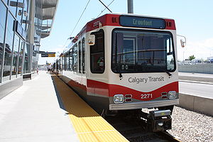
Info Locale Calgary, Alberta Transit type Light rail transit (details) Number of lines 3 in operation
1 under constructionNumber of stations 36 Daily ridership 267,500[1] Operation Began operation May 25, 1981 Operator(s) Calgary Transit Technical Track gauge 4 ft 8 1⁄2 in (1,435 mm) (standard gauge) Electrification Overhead lines, 600 volts DC[2] System map Legend

Tuscany (2014) (2012) 69th Street Station 


Crowfoot 

Dalhousie 
Brentwood (2012) Sirocco 
University Sarcee Trail SW 


Crowchild Trail tunnel (2012) 45th Street Station 

(2012) Westbrook 
Banff Trail 
19th Street tunnel (2012) Shaganappi Point 
14th Avenue Level Crossing Crowchild Trail underpass 
Lions Park 

14th Street NW overpass (2012) Sunalta 

SAIT Way Level Crossing SAIT/ACAD/Jubilee future West Line 202 

10th Street NW (2012) 11th Street Station Sunnyside 10th Street Station 


Bow River bridge NW 


Northwest Line 201 8th Street Station 

7th Street Station 6th Street Station 4th Street Station 3rd Street Station 1st Street Station Centre Street Station 

City Hall 8th Avenue S. tunnel 


South Line 201 

Northeast Line 202 CPR tunnel Victoria Park/Stampede Bow River bridge NE Elbow River bridge SE Bridgeland Memorial Erlton/Stampede Calgary Zoo Cemetery Hill tunnel 
CN Rail overpass 39 Avenue Station 
Deerfoot Trail overpass 42 Avenue tunnel Barlow/Max Bell Chinook Barlow Trail overpass Glenmore Trail underpass 
Franklin Macleod Trail underpass Heritage Memorial Drive NE tunnel Haysboro Storage Yards 

Southland Marlborough Anderson 16th Avenue NE overpass Anderson LRT Yards Rundle Canyon Meadows Whitehorn McKnight Boulevard NE overpass 

Oliver Bowen Yards Fish Creek-Lacombe 
McKnight-Westwinds Shawnessy Martindale (2012) Somerset-Bridlewood 

Saddletowne (2012) C-Train is the light rail transit (LRT) system in Calgary, Alberta, Canada. It has been in operation since May 25, 1981. The system is operated by Calgary Transit, a department of the Calgary municipal government.
Contents
Operations
The C-Train system currently operates on 48.8 kilometres (30.3 mi) of track, organized into two routes. The light rail track isn't an isolated network as a connection to the conventional Canadian Pacific Rail line exists via a track switch near Heritage Station.
The longest route numbered 201 serves the southern and northwestern areas, while the shorter route, 202, serves the northeastern sections of the city. Most track is at grade with its own right-of-way. The downtown portion is shared right-of-way serving both routes along the 7th Avenue transit mall at street level. This portion is a zero-fare zone and serves as a downtown people mover. The tracks split at the east and west ends of downtown into lines leading to the south, northeast and northwest residential neighbourhoods of Calgary. An additional line is currently being implemented to extend route 202 to the western neighbourhoods. Eight percent (8%) of the system is underground, and 5% is grade-separated (elevated). Trains are powered by overhead electric wires, using pantographs to draw power. In the early 2000s, Calgary Transit began using the spelling CTrain for the LRT system, although this variation has not passed into general use and local media continue to use C-Train.
In the third quarter of 2010, the C-Train system had an average of 252,600 revenue riders per weekday, the second busiest light rail system in North America behind the Monterrey Metro.[3]
History
The idea of rail transit in Calgary originated in a 1967 Calgary transportation study, which recommended a two-line metro system to enter service in 1978. The original plans had called for two lines, a northwest-to-south line (on a similar routing to the present-day Northwest and South lines) between the original Banff Trail station (at Crowchild Trail and Northland Drive, between the present-day Brentwood and Dalhousie stations) and Southwood station (at Southland Drive, roughly at the location of the present-day Southland station, with five stations in downtown underneath 7 Avenue; and the west line, which ran from downtown to the community of Glendale, primarily along the 26 Avenue SW corridor. A fourth line, a north central line running from downtown to Thorncliffe mostly along Centre Street was also envisioned, but was thought to be beyond the scope of the study. However, a building boom in the 1970s had caused the heavy rail concept to fall out of favour due to the increased costs of construction, with light rail as its replacement. LRT was chosen over dedicated busways and the expansion of the Blue Arrow bus service (a service similar to bus rapid transit today) because light rail has lower long-term operating costs and to address traffic congestion problems – indeed, the Blue Arrow service all but disappeared in 2000.
The present-day C-Train originated in a 1975 plan, calling for construction of a single line, from the downtown core (8 Street station) to Anderson Road (the present-day Anderson station. The plan was approved by City Council in May 1977, with construction of what would become the LRT's South Line beginning one month later. The South line opened on May 25, 1981. Though the South Line was originally planned to extend to the northwest, political pressures led to the commission of the Northeast Line, running from Whitehorn station (at 36 Street NE and 39 Avenue NE) to the downtown core, with a new downtown terminal station for both lines at 10 Street SW, which opened on April 27, 1985. The Northwest Line, the extension of the South line to the city's northwest, was opened on September 17, 1987, in time for the 1988 Winter Olympics. This line ran from the downtown core to University station, next to the University of Calgary campus. Since then, all three lines have been extended incrementally, with most of the stations commissioned and built in the 2000s:
August 31, 1990 Brentwood station Northwest Line October 9, 2001 Canyon Meadows station
Fish Creek-Lacombe stationSouth Line December 15, 2003 Dalhousie station Northwest Line June 28, 2004 Shawnessy station
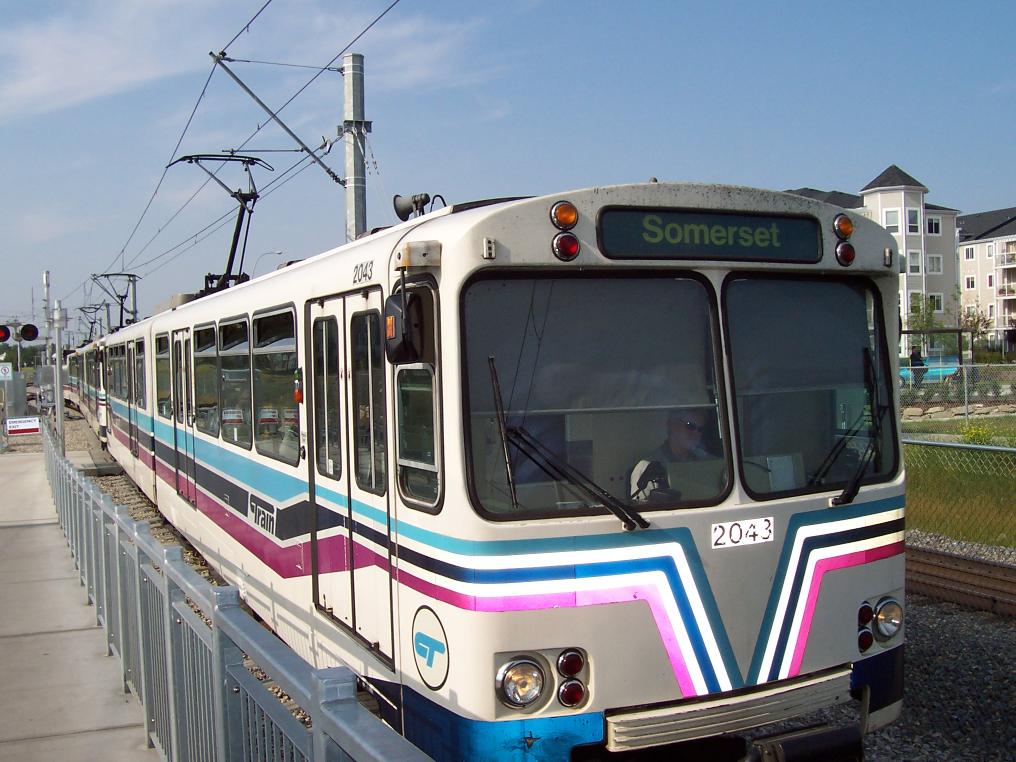
Somerset-Bridlewood stationSouth Line December 17, 2007 McKnight-Westwinds station Northeast Line June 15, 2009 Crowfoot station Northwest Line The system initially used Siemens-Duewag U2 LRVs (originally designed for German metros, and used by Edmonton's earlier LRT and the U-Bahn, a light rail system in Frankfurt), which constituted the entire fleet until mid-July 2001, when the first Siemens SD-160 cars were delivered. There are now seventy-two SD-160s and eighty U2s in service (the eighty-third U2 was lost in a March 2001 accident, the eighty second was lost in an accident in late 2006, the eighty-first was lost in late 2007/early 2008).
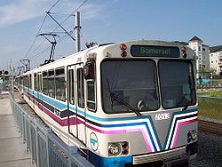
 Somerset-Bridlewood station on the south C-Train line.
However, demand for light rail has exploded in recent years. In the decade prior to 2006, the city's population grew by 25% to over 1 million people, while ridership on the C-Train grew at twice that rate, by 50% in only 10 years. This resulted in severe overcrowding on the trains and demands for better service. In December 2004, city council approved an order for 33 additional SD-160 vehicles from Siemens, and in December 2006, approved an order for an additional 7. In November 2007 city council approved purchasing another 38 SD-160 LRVs to be used in conjunction with the West LRT extension and further expansions to the NE and NW legs. When all are finally delivered, the city's fleet will include 227 light rail vehicles. At that point in time the city will increase the frequency of trains from one every 5 minutes to one every 3 minutes during rush hour.[citation needed]
As of 2007 there is a total of 48.8 km of track; the three lines are 20.7 km (the southern line), 12.5 km (the northeastern line), and 15.0 km (the northwestern line) in length.
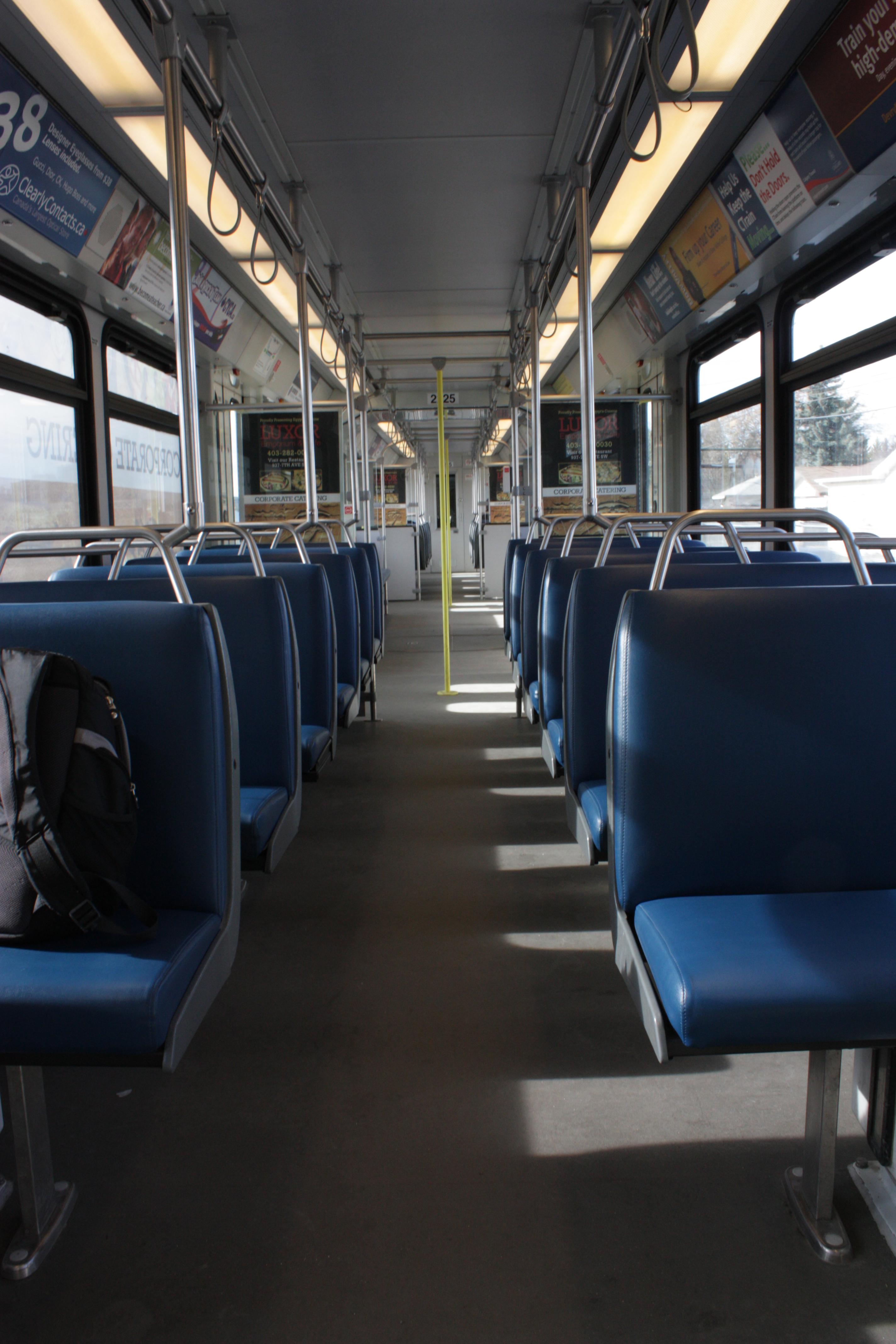
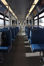 Interior of the Siemens SD-160 operated by Calgary Transit
In 2001, the C-Train became the first public transit system in Canada to claim all of its electricity from emissions-free wind power generation. The electricity is generated by Enmax operating in the southernmost region of Alberta.[4][5] The trains are powered from the same power grid as before; however, an equivalent amount of electricity is produced at the southern wind farms and "dedicated" to the C-Train. Under Alberta's deregulated market for electricity, large consumers can contract to purchase their electricity from a specific vendor, although the individual electrons received off the province-wide grid may not be exactly the same as those transmitted. The only requirement is that supply and demand be the same at each end.
On February 18, 2009, Calgary Transit announced that the C-Train had carried one billion (1,000,000,000) riders in the 28 years since the start of service on May 25, 1981.[6] The trains were now carrying over 280,000 passengers every weekday, higher than any other light rail system in Canada or the United States. Mayor Dave Bronconnier stated that more vehicles were on order to deal with crowding, the northeast and the northwest legs were being extended, and construction of the new west leg was due to start later in the year.[7]
In the following section preliminary timelines for construction of future stations are referenced. For example, construction of a north C-Train line is not expected until after 2023. It should be noted that the city has, on several occasions, accelerated construction of C-Train expansion due to demand and available money. For example the McKnight-Westwinds station, which opened in 2007, was, as recently as 2002, not planned until beyond 2010. Similarly, the timeline of construction of the south line extension was also pushed up several years due to increasing population and traffic volume. There are plans to develop new routes into the center north and the southeast of the city.
In 2010, the entire CCTV Security Camera network was replaced with new, state of the art, IP based cameras along with a new 10GB Fiber-optic network ring to each leg of the LRT line. The project was completed by Contava Inc and will see continuous future upgrades as new stations and technology become available.
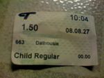 A ticket purchased from a CTrain station.
Fares
Rides taken solely within the downtown are free. This is known as the 7th Avenue Free Fare Zone and encompasses all C-Train stations along 7th Avenue.[8] Fares for regular travel are shown in the accompanying table. In addition to the fares below, on March 16, 2009, Calgary Transit began charging a $3 parking fee in all Park and Ride lots, except between the hours of 6 pm and 2 am on weekdays and all day weekends and holidays. A $60 monthly parking pass is also offered.[9] Full-time students attending Alberta College of Art and Design, SAIT Polytechnic, Mount Royal University, and the University of Calgary, pay into the UPass program through a fee on their tuition that provides students full access to transit services during each school semester.[10][11][12]
Fare Type Price (Canadian dollars)[13] Cash Fare $2.75 Youth Cash Fare $1.75 Book of 10 Tickets $24.00 Book of 10 Youth Tickets $15.00 Day Pass $8.25 Youth Day Pass $5.25 Monthly Pass $90.00 Youth Monthly Pass $54.25 Monthly Pass, Reduced Rate $40.00 Senior Citizen Annual Pass $35.00 Senior Citizen Annual Pass, Reduced Rate $15.00 UPass – Mount Royal University $105.00[10] UPass – SAIT Polytechnic $105.00[12] UPass – University of Calgary $105.00[11] Route details
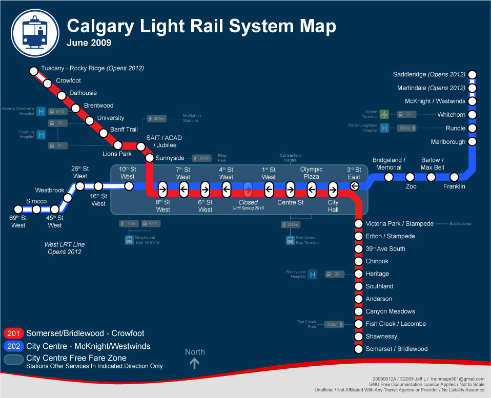
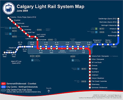 Calgary Light Rail System Map
There are currently two major routes in operation: Route 201 (Somerset/Bridlewood–City Centre–Crowfoot) and Route 202 (McKnight/Westwinds–City Centre).
Route 201
This route comprises two lines: the south line, which was the first of the three lines to be built, and the northwest line, which is the newest of the three lines to be built. Currently there are eleven stations on the south line (of which two opened on June 28, 2004) and eight on the northwest line.
Downtown Line
As part of the original Route 201 south line, nine stations were built along 7th Avenue S, which formed the 7th Avenue Free Fare Zone. The track runs at grade in a semi-exclusive right of way, shared with buses and city and emergency vehicles.
Westbound stations consisted of Olympic Plaza (known as 1st St SE until 1987), 1st St SW, 4th St SW, and 7th St SW. Since all downtown stations have side platforms, a switch west of the 7th Street SW station allowed a westbound train to cross over to east-bound tracks at the 8th St SW station. The eastbound stations were followed by 6th St SW, 3rd St SW, Centre Street and City Hall (known as 2nd St SE until 1987). When the northeast leg opened (Route 202), a center platform 10th St SW was added, and was the terminus for both Route 201 and Route 202 until the northwest extension of Route 201 opened in 1987, it will remain the terminus of Route 202 until 2012.
South Line
Seven stations on this line opened on May 25, 1981, as the first light railway line to serve the city. From north to south, they are Victoria Park/Stampede (originally Stampede), Erlton/Stampede (originally Erlton), 39 Avenue (originally 42 Avenue), Chinook, Heritage (also the site of the Haysboro LRT Storage Facility), Southland, and Anderson (also the site of the Anderson LRT Yards). On October 9, 2001, two new stations were added: Canyon Meadows and Fish Creek-Lacombe. On June 28, 2004, two more stations opened: Shawnessy and Somerset-Bridlewood. A further three stations—Silverado (most likely in the area of 194th Avenue SW), 212th Avenue South, and Pine Creek (in the area around 228th Avenue SW) – are planned for the future once the communities adjacent to their location are developed, likely beyond 2020.[14]
Northwest Line
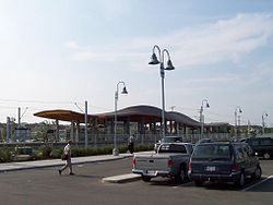
Five stations on this line opened on September 7, 1987. From the most central to the most northwesterly, they are Sunnyside, SAIT/ACAD/Jubilee (the station name in full is "Southern Alberta Institute of Technology/Alberta College of Art and Design/Jubilee Auditorium"), Lions Park, Banff Trail, and University. On August 31, 1990, Brentwood station was opened as a new terminus, and on December 15, 2003, Dalhousie Station was opened. An eighth station – Crowfoot (formerly Crowfoot-Centennial) – opened on June 15, 2009.[15] A ninth station – Tuscany (formerly Tuscany-Rocky Ridge) – was approved in November 2007 for completion by 2014.[16] An intermediate station near Northland Drive is possible in the future as well (between Brentwood and Dalhousie).
Route 202
This route comprises one line: the northeast line. Seven of these stations opened on April 27, 1985; from most central to most northeastern, they are: Bridgeland/Memorial, Zoo, Barlow/Max Bell, Franklin, Marlborough, Rundle, and Whitehorn. An eighth station – McKnight/Westwinds – opened in 2007. Two more stations – expected to be named Martindale and Saddletowne[17] – were approved by city council in November 2007 for completion by 2011.[16] Additional stations are proposed for future development, likely beyond 2023, at 96th Avenue, Country Hills Boulevard, 128th Avenue (north of Skyview Ranch) and Stoney Trail (in the Stonegate Landing development),[17] as those areas are developed.[18]
Future lines
Plans exist to build two additional lines from the city centre: a westbound line (which would extend Route 202), and a southeastern line. A third, northern line is to be planned beyond 2023. Note: station names listed below are subject to change (as Calgary Transit has, on several occasions in the past, renamed approved stations prior to construction).
West LRT
The plans for this line, which runs west from downtown, have existed since the beginning of construction of the South Line in 1978.[19] Construction began in 2009 and will open March 2013, instead of December 12, 2012, because of utility work delays for the Bow Trail and 17th Avenue SW corridors.[20]
The City of Calgary began a review process in late 2006 to update the plans to current standards, and Calgary City Council gave final approval to the project[21] and allocated the required $566-million project funding on November 20, 2007.[16] Funding for the project will be sourced from the infrastructure fund that was created as a result of the Province of Alberta returning the education tax portion of property taxes to the city. Construction of this line began in 2009 and is being constructed at the same time as further extensions of the NE and NW lines of the LRT system that were approved in November 2007.
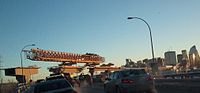 West LRT construction over Bow Trail
The West LRT line has six station to be named (from east to west): Sunalta (near 16th Street S.W.), Shaganappi Point, Westbrook, 45th Street West (Glendale), Sirocco, and 69th Street West (west of 69th Street S.W. near Westside Recreation Centre).
The updated alignment from the 2007 West LRT Report[17] includes the line running on an elevated guideway beginning west of the future 11th Street S.W. station, running along the CPR right of way to Bow Trail S.W., and then to 24th Street S.W. The line will then run at grade past Shaganappi Point Station and drop into a tunnel to 33rd Street SW. The tunnel will then run under the Westbrook Mall parking lot, and the current site of the decommissioned Ernest Manning Senior High School. The line will then follow the north side of 17th Avenue S.W. past 37th Street S.W. below grade to 45th Street Station. Past 45th Street the line will run at grade, and approaching Sarcee Trail S.W. will move onto an elevated guideway that will pass over Sarcee Trail S.W. The line will then run at grade to the Sirocco Station, and then proceed to drop below grade and pass under eastbound 17th Avenue S.W. at 69th Street S.W. and return to grade on the south side of the avenue. The line will then terminate at the site of the final station located to the west of 69th Street S.W. (tentatively known as College Station due to the proximity to two private colleges that are located adjacent to the station).[22]
Three of the new West LRT stations will be located at grade. Westbrook, 45 Street SW,[23] and 69th St. SW stations will be located below grade, while Sunalta will be an elevated station.[24] On October 5, 2009, the city council announced approval of a plan to put a portion of the west LRT line in a trench at 45th Street and 17th Avenue SW, a move welcomed by advocates who fought to have it put underground. The change will cost an estimated $61 million, however lower than expected construction costs are expected to absorb much of the change. The cost for the project is now over budget by at least C$35 million and the overall cost could be more than C$1.46 billion because of soaring costs of land used.[25]
On October 29, 2009 city council announced that the contract to construct the West LRT had been awarded to a consortium led by SNC Lavalin.[26]
Future extension of the West LRT to Aspen Woods Station (around 17th Avenue and 85th Street SW) has been planned, and future extensions further west to 101st Street SW may be added as new communities adjacent to 17th Avenue SW are built.[22]
Southeast Line
This line is planned to run from downtown (although on a different routing, not following the 7th Avenue corridor) to the communities of Douglasdale and McKenzie Lake and McKenzie Towne in the southeast, and onwards past Highway 22X into the so-called "Homesteads" region east of the Deerfoot Trail extension. Eighteen stations have been planned for this route, of which up to eleven are expected to be built by 2023. Three of the proposed downtown stations are expected to be built underground,[27] and the rest of the line will follow the 52 Street SE corridor from Douglasdale and McKenzie Towne to Auburn Bay (south of Highway 22X) and then wind its way through Health Campus (adjacent to a planned southeast hospital) and Seton. Unlike Routes 201 and 202, which use high-floor U2 and SD-160 LRVs, the eastern route is expected to employ low-floor LRVs,[28] such as the Siemens Avanto.
From north to south, the proposed stations are: Eau Claire, Central (at 6 Avenue), Macleod Trail, 4 Street SE, Ramsay/Inglewood, Crossroads, Highfield, Lynnwood, Ogden, South Hill, Quarry Park, Douglasglen (the last expected by 2023), Shepard, Prestwick, McKenzie Towne, Auburn Bay/Mahogany (at 52nd Street), Health Campus/Seton (the station likely will share the name of the hospital), with further stations to the south expected in the future.[29] [30]
North Line
Although it is not expected to be built until beyond 2023[31], this line for which a route has not yet been approved by council south of Beddington Trail or north of Stoney Trail, would serve the residential communities of Country Hills, Coventry Hills, Harvest Hills, and Panorama Hills, and could extend north to Airdrie.[32] The line is planned to connect to a proposed multi-mode transportation hub at 96th Avenue before reaching Harvest Hills Boulevard, connecting the airport, bus service, and a proposed high-speed rail service to Edmonton.[33]
Other future improvements
 Although newer models have been purchased, almost all of Calgary's original trains remain in service.
Currently, Calgary Transit operates three-car trains. The five newest stations—Crowfoot, Dalhousie, McKnight-Westwinds, Shawnessy, and Somerset-Bridlewood along with the refurbished 1st Street S.W., 4th Street SW, and 6th Street SW stations in downtown—have been built to accommodate trains of four cars. It is planned to refurbish all other downtown stations, and to expand original stations outside of downtown to support four car trains. The downtown stations and the south line will be lengthened first, ending in 2013; followed by the northwest line (so as to be able to run four-car trains on Route 201) in 2015. Stations on the northeast line is expected to be extended in 2017. By 2023 Calgary Transit also plans to begin decommissioning some of the original Siemens-Duewag U2s (as of 2008 seventy nine of the original eighty-three are in service, and are nearing twenty-seven years of service, and by 2023 will be forty-two years old). Additional LRVs have been added to the system to accommodate growth, including 72 Siemens SD160 LRVs as of late 2008, with an additional 38 ordered in conjunction with the NW and NE LRT extensions, and the West LRT, which will be completed by 2011 and 2012, respectively.
Downtown station refurbishment
In June 2007 the City of Calgary released information on the schedule for the refurbishment of the remaining original downtown stations.[34] The plan involves replacing and relocating most stations, and expanding Centre Street station which was refurbished in 2001, to board four-car trains. The new stations will retain existing names, however they may be shifted one block east or west, or to the opposite side of 7th Avenue. The first station to undergo refurbishment was the 7th Street SW station, which was relocated one block to the east and re-opened on February 27, 2009.[35] The 6th Street SW, 4th Street SW and 3rd Street SW stations will be reconstructed in place, with 6th Street SW opening in early 2009 and the others following in 2010. This requires that the stations be closed during demolition and reconstruction, however only one station will be closed at any one time. The new stations will feature longer platforms for longer trains, better integration of the platforms into the sidewalk system, better lighting, and more attractive landscaping and street furniture.
The 10th Street SW Station, which is currently the terminus for Route 202 in the downtown, will be replaced with a new station located one block to the west at 11th Street SW. This station was initially proposed to be undertaken as the first station to be completed in the refurbishment project, however it has been pushed back and will now be completed closer to 2012 and the opening of the West LRT.
Underground infrastructure
In addition to numerous tunnels to allow trains to pass under roadways, geographic features, and mainline railways, there are other notable underground portions of Calgary's C-Train system.
Part of the system through downtown is planned to be transferred underground when needed to maintain reliable service. Given this, portions of the needed infrastructure have been built as adjacent and associated land was developed.[36] As a result of this original plan, when the City of Calgary built a new Municipal Building, it built a short section of tunnel to connect the existing CPR tunnel to the future tunnel under 8th Avenue S. The turnoff to this station is visible in the tunnel on Route 201 entering downtown from the south, shortly before City Hall. However, after urban explorers discovered the tunnel and visited it during a transit strike[citation needed], the city walled off the spur tunnel with cinder blocks.
As the population of metropolitan Calgary increases and growing suburbs require new lines and extensions, the higher train volumes will exceed the ability of the downtown section along 7th Avenue S to accommodate them. To provide for long-term expansion, the city is reviewing its plans to put parts of the downtown section underground. The current plans allow the expanded Route 202 (Northeast/West) to use the existing 7th Avenue S surface infrastructure. The expanded Route 201 (Northwest/South), currently sharing 7th Avenue S with Route 202, will be relocated to a new tunnel dug beneath 8th Avenue S. The future Southeast/Downtown route will probably enter downtown through a shorter tunnel under one or more streets (candidates include 2nd Street W, 5th Street W, 6th Street W, 8th Avenue S, 10th Avenue S, 11th Avenue S, and 12th Avenue S). The future North line will probably share track from the Zoo station through downtown with the existing Northeast line (Route 202), avoiding the cost of a tunnel until passenger volumes grow.[29] Although Calgary City Council commissioned a functional study for the downtown metro component of the C-Train system in November 2007, the city is unlikely to complete this expansion before 2017 unless additional funding is received from provincial or federal governments.
List of C-Train stations
The typical C-Train station outside the downtown core allows for several methods of passenger arrival and departure. Many C-Train passengers travel to and from suburban stations on feeder bus routes that wend their way through surrounding neighbourhoods. Another popular option is a Park and Ride lot, in which commuters drive to a station by car and then transfer to a C-Train to complete their journey. Alternatively, some C-Train passengers disembark at drop-off zones from vehicles travelling elsewhere; because many of these commuters are conveyed by their spouses, these zones are branded as Kiss and Ride areas.
Route 201
Route 202
Future stations
Station Route Area Open Location Tuscany Route 201 NW 2014 51°08′07″N 114°14′15″W / 51.13528°N 114.2375°W Martindale Route 202 NE 2012 51°07′11″N 113°57′39″W / 51.11972°N 113.96083°W Saddletowne Route 202 NE 2012 69th St. SW Route 202 West 2013 51°02′15″N 114°11′26″W / 51.0375°N 114.19056°W Sirocco Route 202 West 2013 51°02′13″N 114°10′17″W / 51.03694°N 114.17139°W 45th St. SW Route 202 West 2013 51°02′16″N 114°09′12″W / 51.03778°N 114.15333°W Westbrook Route 202 West 2013 Shaganappi Point Route 202 West 2013 51°02′29″N 114°07′24″W / 51.04139°N 114.12333°W Sunalta Route 202 West 2013 51°02′41.28″N 114°05′56″W / 51.0448°N 114.09889°W Reasons for success
The C-Train's high ridership rate and cost effectiveness is attributed to a number of factors. The nature of Calgary itself has encouraged C-Train use. Calgary has a dense downtown business district, with the second most corporate head offices in Canada after Toronto, most of them crowded into about one square kilometre of land. In recent decades the population has grown dramatically, outpacing the ability of roads to transport people into the city.[37]
Costs were controlled during construction and operation of the system by using relatively cheap, existing technology. A grade separated system was passed over in preference of a system without significant elevated or buried elements and the trains and stations selected were of the tried and tested, utilitarian variety (for example, vehicles are not air conditioned, storage yards are not automated and stations are in general concrete platforms with a modest shelter overhead). This allowed more track to be laid with the available funds and contrasts with the Edmonton Light Rail Transit which buried the portion of the system in downtown and under the University of Alberta, increasing costs. The C-Train uses a self service model of payment, reducing fare collection costs.
In 2001, the US General Accounting Office released a study of the cost-effectiveness of American light rail systems.[38] Although not included in the report, Calgary had a capital cost of US$24.5 million per mile (year 2000 dollars), which would be the sixth lowest (Edmonton was given as US$41.7 million per mile). Because of its high ridership (then 188,000 boardings per weekday) the capital cost per passenger was $2,400 per daily passenger, by far the lowest of the 14 systems compared (had Edmonton been included it would have been the next most cost effective at $8,900 per weekday passenger, while the closest American system was Sacramento at $9,100 per weekday passenger). Operating costs are also low, in 2005, the C-Train cost CDN$163 per operating hour to operate. With an average of 600 boardings per hour, cost per LRT passenger is CDN$0.27, compared to $1.50 for bus passengers in Calgary.[39]
Planning for the C-Train also played an important role. Although the light rail system was not chosen until 1976, the city had reserved transit corridors for some form of high capacity transport in the 1960s, and planning for the system was done when Calgary's population was less than 500,000. The city reached an agreement with CP Rail to build most of the south line along their existing right-of-way. The lines and stations were placed to serve large residential areas and business districts and to serve existing and predicted travel patterns. Feeder bus stations were established.
The city chose not to build major freeways into the city centre, forcing commuters to use the train as their numbers increased but downtown street capacity did not. Similarly, the city limited the number of parking spaces in the downtown core, making it prohibitively expensive for many people to drive to downtown jobs, particularly as surface lots gave way to development. Downtown unreserved monthly parking is amongst the most expensive in North America, behind only Midtown and Downtown Manhattan for business districts.[40] As a result, in 2006 over 42% of Calgary's 112,000 downtown workers used Calgary Transit to get to work.
Although not generally grade separated, the C-Train is able to operate at high speeds on much of its track by separating it from pedestrians with fences and concrete bollards. Trains are also given right of way at most road crossings outside of downtown. As a result, trains are able to operate at 80 km/h (50 mph) outside of downtown, and 40 km/h (25 mph) along the 7th Avenue corridor. 7th Avenue is a free fare zone, encouraging use for short hops through the city. The city achieves high capacity on the 7th Avenue transit corridor by staging the traffic lights, so that all the trains move forward in unison to the next station on the synchronized green lights, and load and unload passengers on the intervening red lights.[39]
Facilities
- Anderson Garage – LRV indoor storage and training facilities
- Haysboro Garage – small indoor and outdoor LRV storage; LRV yard and Turner Storage Area
- Oliver Bowen Maintenance Centre – major LRV repair and shops; storage for 60 cars (and up to 108 cars after expansion)
See also
References
- ^ "APTA Ridership Report – Light Rail" (PDF). American Public Transportation Association. Fourth quarter 2010. http://www.apta.com/resources/statistics/Documents/Ridership/2010_q4_ridership_APTA.pdf. Retrieved 2011-05-15.
- ^ "SD160 Light Rail Vehicle: Calgary, Canada" (PDF). Siemens Transportation Systems, Inc. 2007. http://www.mobility.siemens.com/shared/data/pdf/sts_usa_internet/calgary_sd160.pdf. Retrieved January 23, 2011. "Catenary supply voltage: 600 Vdc"
- ^ "Principales características del sistema de transporte colectivo metrorrey". INEGI. http://dgcnesyp.inegi.gob.mx/cgi-win/bdieintsi.exe/SER15157. Retrieved 2009-06-16.
- ^ "Ride the Wind". Calgary Transit. March 3, 2011. http://www.calgarytransit.com/environment/ride_the_wind.html. Retrieved April 16, 2011.
- ^ Cuthbertson, Richard (February 17, 2011). "City wants electric car test". Calgary Herald (Postmedia Network). http://www.calgaryherald.com/technology/City+wants+electric+test/4299222/story.html. Retrieved April 16, 2011.
- ^ Logan, Shawn (February 19, 2009). "C-Train's the rail thing for one-billionth rider". The Calgary Sun. http://www.calgarysun.com/news/2009/02/19/8445786-sun.html. Retrieved 2009-02-27.
- ^ "CTrain Carries its One Billionth Customer" (Press release). City of Calgary. February 18, 2009. http://newsroom.calgary.ca/pr/calgary/PRN-release20090218_123907_6074_0.aspx. Retrieved April 16, 2011.
- ^ Calgary's Light Rail Transit Line (Calgary Transit page)
- ^ Calgary Transit. "Calgary Transit Park and Ride Services". http://www.calgarytransit.com/html/park_n_ride.html. Retrieved 2009-06-23.
- ^ a b "UPass FAQ". Mount Royal University. http://www.mtroyal.ca/AboutMountRoyal/TransportationParking/U-PassFAQs/U-Pass%20FAQs.htm. Retrieved 2010-09-26.
- ^ a b "UPass – What is it?". University of Calgary. http://www.ucalgary.ca/UPASS/whatis. Retrieved 2010-09-26.
- ^ a b "SAIT Transit or Parking – Frequently Asked Questions". SAIT. http://sait.ca/studentservices/transportationandparking/FAQs/index.shtml. Retrieved 2010-09-26.
- ^ Calgary Transit – Fares
- ^ Calgary Transit (2008) (PDF). Calgary LRT Network Plan. City of Calgary. p. 5. http://calgarytransit.com/pdf/ct_lrt_network_plan.pdf. Retrieved 2009-01-01.
- ^ Calgary Transportation Infrastructure (2007). "Northwest LRT Extension – Dalhousie CTrain Station to Crowfoot CTrain Station". City of Calgary. Archived from the original on 2007-12-29. http://web.archive.org/web/20071229020959/http://www.calgary.ca/portal/server.pt/gateway/PTARGS_0_2_771_203_0_43/http;/content.calgary.ca/CCA/City+Hall/Business+Units/Transportation+Infrastructure/Construction+Projects/LRT/Northwest+LRT+Extension/Northwest+LRT+Extension.htm. Retrieved 2007-12-22.
- ^ a b c Calgary City Council (2007). "Minutes of Calgary City Council special meeting of 06 November 2007" (MS Word). City of Calgary. http://publicaccess.calgary.ca/lldm01/livelink.exe?func=ccpa.general&msgID=IeqqTregrD&msgAction=download. Retrieved 2007-12-22.
- ^ a b c Calgary Transportation Planning (November 20, 2007) (PDF). 2007 West LRT Report. City of Calgary. http://www.calgarytransit.com/pdf/west_lrt_2007_report.pdf. Retrieved 2007-12-22.
- ^ Calgary Transit (2008) (PDF). Calgary LRT Network Plan. City of Calgary. p. 6. http://calgarytransit.com/pdf/ct_lrt_network_plan.pdf. Retrieved 2009-01-01.
- ^ Calgary Transportation Department (1983) (PDF). West LRT Functional Study. City of Calgary. http://www.calgarytransit.com/pdf/West_LRT_Report_1983_Consolidation.pdf. Retrieved 2007-12-22.
- ^ Cuthbertson, Richard (November 10, 2011). "West LRT’s deadline detour leaves budgets derailed by $35M". Calgary Herald. http://www.calgaryherald.com/business/energy-resources/West+deadline+detour+leaves+budgets+derailed/5693850/story.html. Retrieved 2011-11-11.
- ^ CBC News (November 20, 2007). "Council confirms route for C-Train's west line". Canadian Broadcasting Corporation. http://www.cbc.ca/canada/calgary/story/2007/11/20/west-lrt.html. Retrieved 2007-12-22.
- ^ a b City of Calgary (PDF). West LRT Map (Map) (2007 ed.). http://www.calgarytransit.com/pdf/west_lrt_mrc_roadnet_reference_areas.pdf. Retrieved 2007-12-22.
- ^ The Calgary Herald (October 5, 2009). "West LRT leg headed below ground after council vote". The Calgary Herald. http://www.calgaryherald.com/West+headed+below+ground+after+council+vote/2069023/story.html. Retrieved 2009-10-05.
- ^ Calgary Transit (2008) (Flash). West LRT – Route Map. City of Calgary. http://www.westlrt.ca/contentabout/routemap.cfm. Retrieved 2009-06-13.
- ^ Cuthbertson, Richard (November 16, 2011). "Soaring west LRT costs hit $1.46B — and threatening to keep rising". Calgary Herald. http://www.calgaryherald.com/news/calgary/Soaring+west+costs+threatening+keep+rising/5722391/story.html. Retrieved 2011-11-17.
- ^ Mayor Bronconnier Announces Design-Build Award, City of Calgary, October 29, 2009, http://www.westlrt.ca/contentdesign/industry_news.cfm, retrieved June 9, 2010
- ^ Calgary Land Use Planning & Policy (2007) (PDF). City Centre Plan. Part 2, p. 79. City of Calgary. http://www.calgary.ca/DocGallery/BU/planning/pdf/centre_city/centre_city_plan_one.pdf. Retrieved 2007-12-22.
- ^ Calgary Land Use Planning & Policy (2007) (PDF). Beltline Area Redevelopment Plan. Part 2, pp. 85–86. City of Calgary. Archived from the original on September 30, 2007. http://web.archive.org/web/20070930222350/http://www.calgary.ca/DocGallery/BU/planning/pdf/centre_city/beltline/beltline_plan_two.pdf. Retrieved 2007-12-22.
- ^ a b Clifton ND Lea Consulting (2004) (PDF). Southeast LRT Functional Planning Study. Phase III – Glenmore Trail to Elbow River. City of Calgary. http://www.calgarytransit.com/pdf/SE_LRT_Final_Report.pdf. Retrieved 2007-12-22.
- ^ Calgary Transit (2008) (PDF). Calgary LRT Network Plan. City of Calgary. p. 8. http://calgarytransit.com/pdf/ct_lrt_network_plan.pdf. Retrieved 2009-01-01.
- ^ Markusoff, Jason (May 23, 2011). "City launches discussion of north-central LRT route options". Calgary Herald. http://www.calgaryherald.com/City+launches+discussion+north+central+route+options/4828196/story.html. Retrieved 2011-05-24.
- ^ Plan It Calgary (February 29, 2009) (PDF). Draft Calgary Transportation Plan 2009. City of Calgary. http://www.calgary.ca/docgallery/BU/planning/pdf/plan_it/draft_calgary_transportation_plan.pdf. Retrieved April 24, 2010.
- ^ Calgary Transit (2006) (PDF). North Central Calgary Transit Corridor Review. City of Calgary. http://www.calgarytransit.com/pdf/north_central_calgary_transit_corridor_review.pdf. Retrieved 2007-12-22.
- ^ Calgary Transportation Infrastructure (2007). "7 Avenue Refurbishment". City of Calgary. http://www.calgary.ca/portal/server.pt/gateway/PTARGS_0_2_395_203_0_47/http;/content.calgary.ca/CCA/City%20Hall/Business%20Units/Transportation%20Infrastructure/Construction%20Projects/LRT/7%20Avenue%20Refurbishment/7%20Avenue%20Refurbishment.htm. Retrieved 2007-12-22.
- ^ Calgary Transit (2009). "7 Street West Platform Now Open". City of Calgary. http://www.calgarytransit.com/html/7_street_station_info.html. Retrieved 2009-03-11.
- ^ Calgary Planning Department (1982) (PDF). City Hall Area Redevelopment Plan. p. 30. City of Calgary. Archived from the original on March 1, 2008. http://web.archive.org/web/20080301231218/http://www.calgary.ca/docgallery/bu/planning/pdf/city_hall_arp.pdf. Retrieved December 22, 2007.
- ^ Hubbel, John; Colquhoun, Dave (2006). "Light Rail Transit in Calgary, The First 25 Years". 2006 Joint International Light Rail Conference. St. Louis, Missouri: Calgary Transit. http://www.calgarytransit.com/pdf/Calgarys_LRT_1st_25Years_TRB_revised.pdf. Retrieved 2009-09-23.
- ^ General Accounting Office. "Mass Transit: Bus Rapid Transit Shows Promise". Report to Congressional Requesters. http://www.gao.gov/new.items/d01984.pdf. Retrieved August 18, 2009.
- ^ a b Neil McKendrick, Dave Colquhoun, Bob Charles, John Hubbell (April 2006). "Calgary’s CTrain – Effective Capital Utilization". Calgary Transit. http://www.calgarytransit.com/pdf/Calgary_CTrain_Effective_Capital_Utilization.pdf. Retrieved August 18, 2009.
- ^ "Global CBD Parking Rate Study". Colliers International. 2009. http://www.colliers.com/content/Attachments/India/CI_Global_parking_09.pdf. Retrieved October 8, 2009.
External links
- Calgary Transit's official website
- LRT in Calgary (an informative third-party web site)
- transit.mtroyal.ca (Google Maps visualization of Calgary Transit data)
- Network map
Calgary C-Train stations Route 201 Northwest LineTuscany (Open 2014) · Crowfoot · Dalhousie · Brentwood · University · Banff Trail · Lions Park · SAIT/ACAD/Jubilee · SunnysideDowntownSouth LineVictoria Park / Stampede · Erlton/Stampede · 39th Avenue · Chinook · Heritage · Southland · Anderson · Canyon Meadows · Fish Creek – Lacombe · Shawnessy · Somerset–BridlewoodRoute 202 West Line69th St. SW (Open 2012) · Sirocco (Open 2012) · 45th St. SW (Open 2012) · Westbrook (Open 2012) · Shaganappi Point (Open 2012) · Sunalta (Open 2012)DowntownNortheast LineBridgeland/Memorial · Zoo · Barlow/Max Bell · Franklin · Marlborough · Rundle · Whitehorn · McKnight–Westwinds · Martindale (Open 2012) · Saddletowne (Open 2012)Passenger railways of Canada Intercity Sightseeing Commuter rail GO Transit (Greater Golden Horseshoe) • Agence métropolitaine de transport (Greater Montreal) • West Coast Express (Lower Mainland)Metro systems Light rail C-Train (Calgary) • Edmonton Light Rail • Hamilton Light Rail • Hurontario-Main Street LRT (Mississauga) • Kitchener-Waterloo Light Rail • O-Train (Ottawa) • Toronto Pearson Airport People MoverStreetcar Heritage tramways Downtown Historic Railway (Vancouver) • High Level Bridge Streetcar (Edmonton) • Nelson Electric Tramway • Whitehorse trolleySee also: Canadian railways • Light rail in Canada • Canada railwaysCategories:- C-Train
- Railway lines opened in 1981


Wikimedia Foundation. 2010.