- Vancouver Downtown Historic Railway
-
Vancouver Downtown Historic Railway 
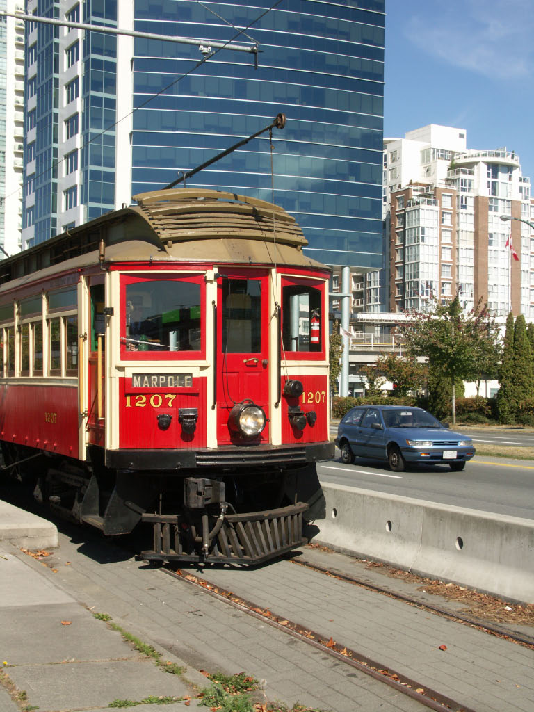
Tram car 1207Overview Type Heritage streetcar, seasonal Operation Opened July 29, 1998 Operator(s) Transit Museum Society Technical Track gauge 1,435 mm (4 ft 8 1⁄2 in) Route map Legend
Granville Island 
Leg-in-Boot 
Science World (closed until further notice) 
Proposed extension to Waterfront Station and Stanley Park The Vancouver Downtown Historic Railway is a heritage streetcar line that operates between Granville Island and the Cambie Station (north of 6th Ave just east of Ash Street) in Vancouver, British Columbia, Canada. It operates only on weekends and holidays, usually from May to mid-October, and is aimed primarily at tourists. Two restored interurban streetcars are used on the line, which used a former freight railway right-of-way.
The VDHR was not operated in 2010; its web site states an "anticipated reopening" on July 1, 2011.[1]
The line is owned by the City of Vancouver. The cars are operated by volunteers from the Transit Museum Society. The car shown (1207) is privately owned.
Service was inaugurated on July 29, 1998, and was considered to be a demonstration project for a modern downtown streetcar system that the city plans to develop.[2] It has continued to operate almost every summer since then, as an excursion-oriented historic streetcar line.
When last fully operational, the line ran from Granville Island to a stop near Science World and Main Street-Science World SkyTrain station. Since then, however, Olympic related construction has razed sections of the line east of the Olympic Village Canada Line Station. The proposal for a modern line would extend the former line through Chinatown and Gastown to Waterfront Station, and eventually to Stanley Park. There would be a separate line into Yaletown with longer term potential for a number of other lines.
Contents
Vancouver 2010 Olympic Line
From January 21 to March 21, 2010, a free demonstration service called the "Olympic Line" (named for the 2010 Winter Olympics) ran on the Downtown Historic Railway, using two modern Bombardier Flexity Outlook streetcars borrowed from the Brussels tramway.[3] The City of Vancouver and the administrators of Granville Island paid $8.5 million for associated upgrades to the infrastructure.
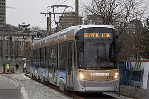 Olympic Line near the Olympic Village Station
The City considered the streetcar demonstration "a tremendous success", with over 550,000 boardings during the two months of the experiment.[4] Bombardier received an award for "Exceptional Performance and Outstanding Achievement" at the 2010 CUTA awards, recognizing its operation of over 13,000 one-way trips with zero equipment failures, zero station delays and zero injuries.[5] Mayor Robertson has indicated a desire to continue operation of the line, with a potential extension to Main Street - Science World Station via False Creek South, but mentioned that the city alone lacks the millions needed to complete the construction and equipment purchases.[6] Nonetheless, a streetcar along the alignment used by the Olympic Line was part of two of the proposals for rapid transit running east-west through the city of Vancouver in 2020.[7]
Fleet of railcars
Make/Model Description Fleet size Year built Year retired Notes built in New Westminster, British Columbia Interurban car 3 - only 1207 remains 1905 1958 ex-British Columbia Electric Railway St. Louis Car Company Tram 1 - 1231 1912 1959 ex-British Columbia Electric Railway The fleet also includes an ex-Brussels La Brugeoise et Nivelles SA. PCC streetcar, painted red and cream.
The line's operator, the Transit Museum Society, also owns a large fleet of vintage buses and trolley coaches.
See also
- List of heritage railways in Canada
- List of museums in Canada
- TransLink (British Columbia)
References
- ^ "Downtown Historic Railway". The Transit Museum Society. http://www.trams.ca/dhr.html. Retrieved 2011-07-02.
- ^ Ward, Doug (1998-7-30). "Electric streetcar launches revival of historic service". The Vancouver Sun.
- ^ "Vancouver's 2010 Streetcar". Bombardier. http://www2.bombardier.com/vancouver/index.html. Retrieved 2009-06-10. "Connecting Granville Island, a key entertainment centre for the 2010 Winter Games, and the Olympic and Paralympic Village Vancouver, the Olympic Line streetcar service will extend Vancouver’s regional transit network along False Creek during 60 days of celebration before and during the 2010 Winter Games."
- ^ "Olympic Line ridership". City of Vancouver. 2010-08-13. http://vancouver.ca/engsvcs/transport/streetcar/olympicLine.htm. Retrieved 2010-08-25.
- ^ "Bombardier Wins Award for the Olympic Line — Vancouver's 2010 Streetcar" (Press release). Benzinga. 2010-05-18. http://www.benzinga.com/pressreleases/10/05/m287728/bombardier-wins-award-for-the-olympic-line-vancouver-s-2010-streetcar. Retrieved 2010-06-16.
- ^ "Robertson Sees Momentum for Transit Funding". The Globe and Mail. http://www.theglobeandmail.com/news/national/british-columbia/robertson-sees-momentum-for-transit-funding/article1480540/. Retrieved 2010-06-16.
- ^ "Rapid Transit Alternatives". Translink. http://www.translink.ca/en/Get-Involved/Be-Part-of-the-Plan/Alternatives.aspx. Retrieved 2010-06-16.
External links
- City of Vancouver's page on the historic railway
- Transit Museum Society's page on the historic railway
- City of Vancouver downtown streetcar project
Passenger railways of Canada Intercity Sightseeing Commuter rail GO Transit (Greater Golden Horseshoe) • Agence métropolitaine de transport (Greater Montreal) • West Coast Express (Lower Mainland)Metro systems Light rail C-Train (Calgary) • Edmonton Light Rail • Hamilton Light Rail • Hurontario-Main Street LRT (Mississauga) • Kitchener-Waterloo Light Rail • O-Train (Ottawa) • Toronto Pearson Airport People MoverStreetcar Heritage tramways Downtown Historic Railway (Vancouver) • High Level Bridge Streetcar (Edmonton) • Nelson Electric Tramway • Whitehorse trolleySee also: Canadian railways • Light rail in Canada • Canada railwaysHeritage railways of Canada Current Defunct WSJR • PWR
Categories:- Transportation in Greater Vancouver
- Tram transport in Canada
- Heritage railways in British Columbia
- Heritage streetcar systems
- Streetcars in Canada

Wikimedia Foundation. 2010.