- Nisga'a Highway
-
Highway 113 Nisga'a Highway Route information Length: 158 km (98 mi) Existed: 2006 – present Major junctions South end:  BC 16 west of Terrace
North end:  BC 37 at Cranberry Junction
Highway system British Columbia provincial highways
←  BC 101
BC 118  →
→The Nisga'a Highway (Highway 113) is a highway that starts in Terrace, British Columbia, Canada at Highway 16. The route provides paved access to the settlements of the Nisga'a Nation - Gitlakdamix (New Aiyansh), Gitwinksihlkw (Canyon City), Gingolx (Kincolith), Laxgalts'ap (Greenville), Nass Camp and others. It enters the Nass Country via the valley of Kitsumkalum Lake, which connects from the Skeena and via the Nisga'a Lava Beds Provincial Park. The route heads north from Terrace and once into the Nass River Valley then travels west to Gingolx (Kincolith). It also intersects BC Highway 37, aka the Dease Lake Highway or Stewart-Cassiar Highway, at the junction community of Cranberry Junction.
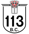
The route received a newly designed shield and was given the numeric designation of Provincial Highway 113 in Summer 2006.[1].
The number 113 is historically significant to the Nisga'a. In 1887, a Nisga'a chief traveled to Victoria to meet with provincial government representatives, demanding self-government.[2] That didn't come until 113 years later in 2000, when the Nisga'a Final Agreement was passed in Parliament.[3].
References
- ^ "British Columbia Ministry of Transportation Staff Newsletter". BC Ministry of Transportation. http://www.th.gov.bc.ca/publications/roadrunners/rr_summer-06.pdf. Retrieved 1 August 2010.
- ^ "CHRONOLOGY OF EVENTS LEADING TO THE FINAL AGREEMENT WITH THE NISGA'A TRIBAL COUNCIL". Indian and Northern Affairs Canada. http://www.ainc-inac.gc.ca/al/ldc/ccl/fagr/nsga/nfa/chrono-eng.asp. Retrieved 1 August 2010.
- ^ "Fact Sheet: The Nisga'a Treaty". Indian and Northern Affairs Canada. http://www.ainc-inac.gc.ca/ai/mr/is/nit-eng.asp. Retrieved 1 August 2010.
See also
External links
Roads of British Columbia Provincial highways 1 · 1A · 2 · 3 · 3A · 3B · 4 · 4A · 5 · 5A · 6 · 7 · 7B · 8 · 9 · 10 · 11 · 12 · 13 · 14 · 15 · 16 · 17 · 18 · 19 · 19A · 20 · 21 · 22 · 22A · 23 · 24 · 26 · 27 · 28 · 29 · 30 · 31 · 31A · 33 · 35 · 37 · 37A · 39 · 41 · 43 · 49 · 52 · 77 · 91 · 91A · 93 · 95 · 95A · 97 (A · B · C · D) · 99 · 101 · 113 · 118 · 395 · South Fraser Perimeter Road (under construction)Other provincially maintained roads Atlin Road · Bridge River Road · Cecil Lake Road · Coalmont Road · Cultus Lake Road · Glover Road · Head Bay Road · Hemlock Valley Road · Horsefly Road · Jesmond Road · Likely Road · Mission Mountain Road · Nazko Road · Omineca Resource Road · Pavilion Mountain Road · Port Mellon Highway · Queen Charlotte City-Skidegate Road · Strathcona Parkway · Telegraph Creek Road · Westside RoadHistorical provincial highways Municipal limited-access roads Barnet Highway · Gaglardi Way · Golden Ears Way · Grant McConachie Way · Knight Street · SW Marine Drive · Marine Way · Russ Baker WayHistoric roads and trails Alaska Highway · Atlin Road · Cariboo Road · Chilkoot Trail · Crowsnest Highway · Dewdney Trail · Dewdney Trunk Road · Douglas Road · Hudson's Bay Brigade Trail · Lillooet Cattle Trail · Nisga'a Highway · Okanagan Trail · Old Cariboo Road · Old Yale Road (Grand Trunk Road) · River Trail · Whatcom TrailSee also Italics denotes highways with expressway sections.
Bold denotes highways with expressway and freeway sections.Categories:- British Columbia provincial highways
- Nass Country
- Canada road stubs
- British Columbia stubs
Wikimedia Foundation. 2010.

