- Skeena River
Infobox River
river_name = Skeena River
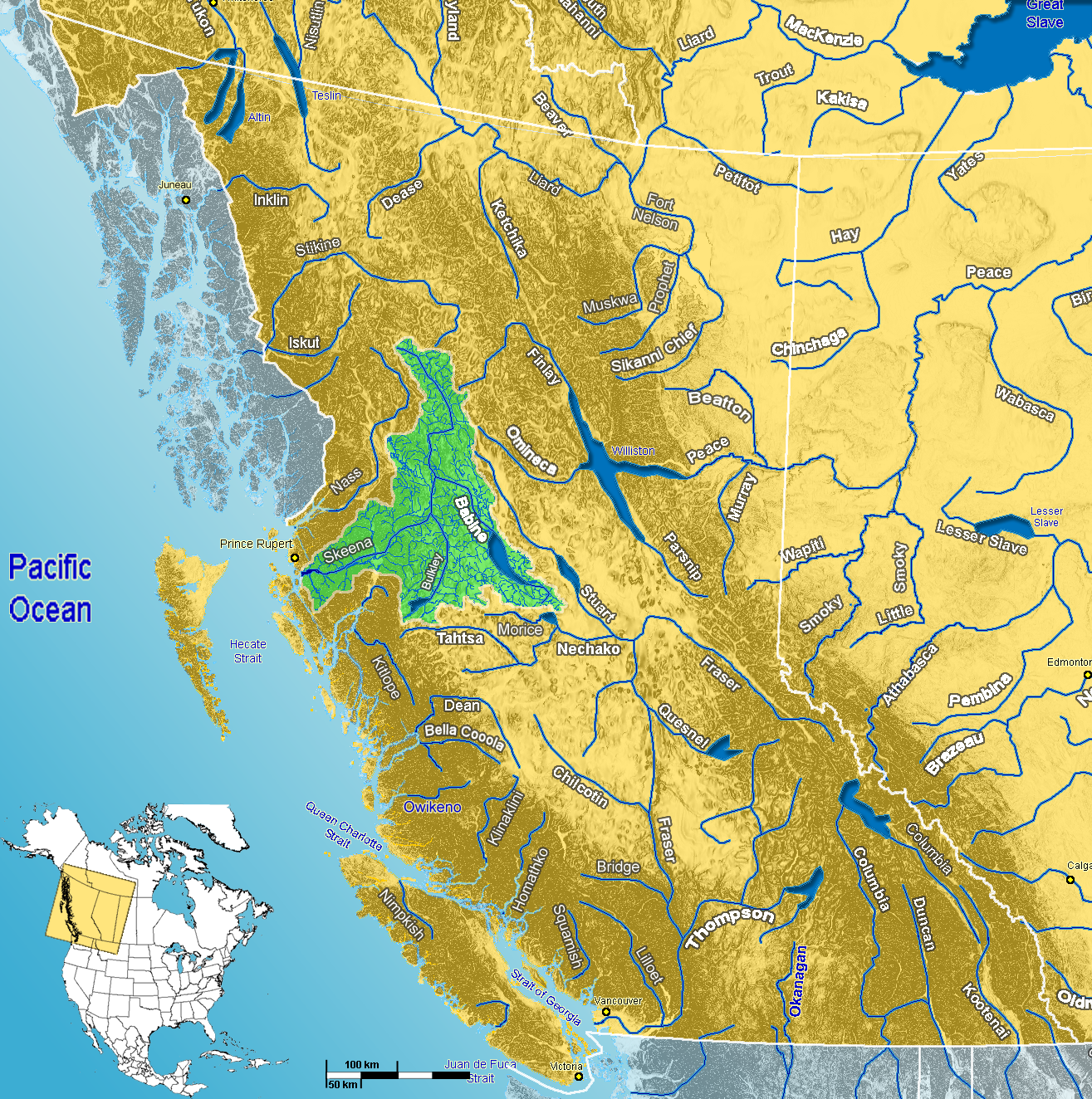
caption = Skeena River Watershed
origin =Spatsizi Plateau
(coord|57|09|06|N|128|41|29|W|scale:60000)
mouth =Hecate Strait (Pacific Ocean )
(coord|54|07|57|N|130|05|57|W|scale:60000)
basin_countries = CAN
length = km to mi|570|abbr=yes
elevation = m to ft|1500|abbr=yes
mouth_elevation = Sea level
discharge = 2,157 m³/s
watershed = km2 to mi2|54400|abbr=yesThe Skeena River is the second longest river entirely in
British Columbia ,Canada . [Cite web|url=http://www.britishcolumbia.com/rivers/?ID=100|title=Skeena River|author=British Columbia.com|accessdate=2008-01-23] The Skeena is an important transportation artery, particularly for theTsimshian and theGitxsan - whose names mean "inside the Skeena River" and "people of the Skeena River" respectively, and also during theOmineca Gold Rush when steamboat services ran from the sea to Hazelton, at the confluence of the Skeena's largest tributary, the Bulkley, which was the jumping-off point for the trails to the goldfields. The river and its basin sustain a wide variety of fish, wildlife and vegetation.Geography
The Skeena originates south of the
Spatsizi Plateau Wilderness Provincial Park in north western British Columbia, forming a divide with theKlappan River , a tributary of theStikine River . It flows for km to mi|570|abbr=yes|wiki=yes [ [http://encarta.msn.com/map_701516572/Skeena.html Map of Skeena River] ] before it empties into Chatham Sound and Ogden Channel , East ofHecate Strait of thePacific Ocean . The Skeena drains km2 to mi2|54400|abbr=yes|wiki=yes of land with a normal annual runoff of 2,157 m3/s or 1190 mm. [http://www.env.gov.bc.ca/wsd/plan_protect_sustain/groundwater/library/bc-runoff.html Normal Runoff from British Columbia - Study 406] , Water Stewardship Division, BC Ministry of the Environment, URL accessed 6 November 2006] .Course
The Skeena River originates at the southern end of
Spatsizi Plateau , in a valley between Mount Gunanoot and Mount Thule, south of theStikine River watershed. An abandoned track of theGrand Trunk Pacific Railway runs along the river in its upper course. It flows south-east, between the shallow peaks of theSkeena Mountains , through the McEvoy and Jackson Flats. It continues in this direction until it passes the Slamgeesh Range, then flows westwards to Fourth Cabin, when it turns south through a shallow canyon below Poison Mountain. After Kuldo it takes an eastward turn, then flows again south below Cutoff Mountain and Mount Pope. It continues through rolling hills to the community of Kispiox and then Hazelton, where it receives the waters of Morice-Bulkley River , and turns south-west. TheYellowhead Highway and aCanadian National Railway track follow the course of the Skeena on this section. At Kitseguecla, the river is crossed by Highway 37, and then turns south around the Seven Sisters Peaks and Bulkley Ranges, through the Skeena Provincial Forest, then between the Nass Ranges and Borden Glacier, past the ferry crossing at Usk, through theKitselas Canyon , and then through theKleanza Creek Provincial Park . It then flows south-west through the city of Terrace, where the river widens. It continues westwards, followed by the Highway 16 andCanadian National Railway line, passes near theExchamsiks River Provincial Park , then flows into theHecate Strait at Eleanor Passage, between Port Edward and Port Essington, facing De Horsey Island.Tributaries
Partial listing from
Fisheries and Oceans Canada [http://www.pac.dfo-mpo.gc.ca/species/salmon/wsp/CU/CU27Sept06.htm Water Systems with Chinook] ,Fisheries and Oceans Canada , URL accessed 6 November 2006]
Upper Skeena
* Bear River, Johanson Creek, Shilahou Creek,Slamgeesh River ,Sustut River Middle Skeena
*Babine River , Boucher Creek, Buck Creek,Bulkley River , Comeau Creek, Cullon Creek, Date Creek, Deep Canoe Creek,Fulton River , Harold Price Creek,Kispiox River ,Kitseguecla River , Maxan Creek, McCully Creek, McQueen Creek,Morice River ,Nangeese River ,Nanika River ,Nilkitkwa River , Pinkut Creek, Richfield Creek,Shegunia River , Simpson Creek, Stephens Creek,Suskwa River ,Sweetin River , Toboggan CreekLower Skeena
* Alwyn Creek, Big Falls Creek, Cedar Creek, Coldwater Creek, Copper River, Deep Creek, Dog Tag Creek,Ecstall River , Erlandsen Creek,Exchamsiks River ,Exstew River , Fiddler Creek,Gitnadoix River , Goat Creek, Johnston Creek, Johnston Lake, Kaeen Creek,Kasiks River ,Khyex River ,Kitsumkalum River ,Kitwanga River , Kleanza Creek,Lakelse River , Lean-To Creek, Limonite Creek, Magar Creek, Moonlit Creek, Salmon Run Creek, Sockeye Creek, Spring Creek, Star Creek, Thomas Creek, Trapline Creek, White Creek, Williams Creek,Zymagotitz River ,Zymoetz River Wildlife
The Skeena supports a wide variety of fish and wildlife. The British Columbia Ministry of the Environment, through BC Parks, has designated a number of Ecological Reserves along the course of the river. [Skeena River Ecological Reserve [http://www.env.gov.bc.ca/bcparks/eco_reserve/skeena_er.html] .]
Fish
The Skeena is well-known for its
sport fishing , most notablysalmon andsteelhead (which are considered distinct from salmon -- seeSalmon#True Salmon ). [For example, see [http://www.fishbc.com/adventure/angling/river/skeena.phtml] ] [http://www.bcadventure.com/adventure/angling/river/skeena.phtml Skeena River - Four Seasons of Skeena Fishing] , http://www.bcadventure.com, URL accessed 6 November 2006] [http://www.zboatbc.com/the-rivers.html The Skeena River] , Z-Boat Lodge River Guides, URL accessed 6 November 2006] The Skeena is also very important to thecommercial fishing industry. For example, numbering 5 million spawning salmon a year, the Skeena is second only to theFraser River in Canada in its capacity to producesockeye salmon . [http://www.pac.dfo-mpo.gc.ca/comm/publications/speciesbook/salmon/sockeye.skeena.html Salmon - Sockeye - Skeena River: Fishery Outlook / Management] ,Fisheries and Oceans Canada , URL accessed 11 November 2006]The following types of
pacific salmon can be found in the Skeena:
*Chinook salmon , sometimes known as King, Tyee, Spring, Quinnat, Tule, or Blackmouth salmon.
*Chum salmon , sometimes known as Dog or Calico salmon.
*Coho salmon , sometimes known as Silver salmon.
*Pink salmon , sometimes known as Humpback salmon.
*Sockeye salmon , sometimes known as Red salmon or Blueback salmon.Bears
The rare
Kermode bear lives in and near the Skeena Valley from Prince Rupert to Hazelton. The region is also home to many black bears andbrown bears .Grizzly bears are less common in the area but theKhutzeymateen Grizzly Bear Sanctuary is located nearby.History
Fur trading
The
Hudson's Bay Company 's local headquarters were at Port Simpson, although Port Essington was also used extensively as a port for its sternwheelers."Pioneer Legacy - Chronicles of the Lower Skeena River - Volume 1", Norma V. Bennett, 1997, ISBN 0-9683026-0-2]Riverboats
While
canoes played a crucial role on the Skeena for centuries, the age of thesteamboat heralded a new era of boating on the Skeena. The first steam-powered vessel to enter the Skeena was the "Union" in 1864. In 1866 the "Mumford" attempted to ascend the river but was only able to reach theKitsumkalum River . It was not until 1891 that the Hudson's Bay Company sternwheeler the "Caledonia" successfully negotiated through theKitselas Canyon and reached Hazelton. A number of other steamers were built around the turn of the century, in part due to the growingfish industry and thegold rush ."Pioneer Legacy - Chronicles of the Lower Skeena River - Volume 1", Norma V. Bennett, 1997, ISBN 0-9683026-0-2]ee also
*
List of British Columbia rivers
*Steamboats of the Skeena River
*List of ships in British Columbia Footnotes
Wikimedia Foundation. 2010.