- British Columbia Highway 7B
-
Highway 7B
Mary Hill Bypass 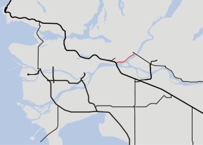
Highway 7B highlighted in redRoute information Length: 9 km (6 mi) Existed: 1996 – present Major junctions West end:  BC 1 in Coquitlam
East end:  BC 7 in Port Coquitlam
Location Major cities: Coquitlam
Port CoquitlamHighway system British Columbia provincial highways
← BC 7BC 8  →
→Highway 7B, known as the Mary Hill Bypass, is a 9 km-long (6 mi) riverside east-west link between the cities of Coquitlam to the west and Port Coquitlam to the east. The Mary Hill Bypass gained its '7B' designation in 1996, when it was widened from two to four lanes. Highway 7B meets Highway 7 at both of its ends, and also links to Highway 1 within Coquitlam at the Cape Horn Interchange.
Contents
Route details
The Mary Hill Bypass skirts around Mary Hill, which was developed in the early 1960s for residential housing. The Mary Hill Bypass begins at an intersection with United Boulevard in Coquitlam. Just west of this intersection are the ramps that connect Highway 1. Although the western end does not directly connect to Highway 7, this connection can be made using United Boulevard towards the north. After crossing the Coquitlam River, the highway continues on, turning east and passing through a major intersection which provides access to downtown Port Coquitlam. Continuing northeast, the Mary Hill Bypass passes through another major intersection, then enters an industrial park and passes through another three intersections. After passing a railway underpass and one final intersection, the Mary Hill Bypass ends at Highway 7, which continues east to Pitt Meadows, Maple Ridge, and Mission.
The speed limit on the Mary Hill Bypass is 70 km/h (40 mph).
Intersections, west to east
Highway 7B is a four-lane expressway route, and only has one interchange at its eastern terminus with Highway 7.
The entirety of the route is in Metro Vancouver.
Location km Destinations Notes Continues as Highway 1 west to Vancouver Highway 7 (Lougheed Highway) west to Vancouver, Burnaby; east to Coquitlam Interchange; no direct access to Highway 7 from Mary Hill Bypass on-ramp Highway 1 east to Hope Interchange; no direct access to Hwy 1 East from Mary Hill Bypass West; use United Blvd. and Highway 7 United Boulevard to Highway 7 City of Port Coquitlam Shaughnessy Street, Argue Street Pitt River Road, Argue Street Broadway Street Coast Meridian Road Kingsway Avenue Holland Avenue Highway 7 (Lougheed Highway) west to Coquitlam; east to Pitt Meadows, Maple Ridge via Pitt River Bridge Continues as Highway 7 to Pitt Meadows & Maple Ridge 1.000 mi = 1.609 km; 1.000 km = 0.621 mi
Concurrency terminus • Closed/Former • Incomplete access • UnopenedNorth Fraser Perimeter Road
As a scope of the Ministry of Transportation's Metro Vancouver Gateway Program,[1] existing roads around the north side of the Fraser River will be improved to create a direct connection between New Westminster and Maple Ridge. This project is known as the North Fraser Perimeter Road, and includes the upgrading of intersections and possibly, construction of interchanges along the Mary Hill Bypass.[2] This project also includes the construction of an interchange at the Mary Hill Bypass and Highway 7 at its eastern terminus and the construction of a new, cable-stayed Pitt River Bridge consisting of 7 lanes (3 westbound, 4 eastbound).[3]
References
- ^ "Gateway Program". Government of British Columbia. http://www.gatewayprogram.bc.ca/. Retrieved 2007-12-20.
- ^ "North Fraser Perimeter Road". Government of British Columbia. http://www.th.gov.bc.ca/gateway/NFPR/NFPR.htm. Retrieved 2007-12-20.
- ^ "Pitt River Bridge and Mary Hill Interchange Project". Government of British Columbia. http://www.th.gov.bc.ca/gateway/prb-maryhill/prb.htm. Retrieved 2007-12-20.
External links
Roads of British Columbia Provincial highways 1 · 1A · 2 · 3 · 3A · 3B · 4 · 4A · 5 · 5A · 6 · 7 · 7B · 8 · 9 · 10 · 11 · 12 · 13 · 14 · 15 · 16 · 17 · 18 · 19 · 19A · 20 · 21 · 22 · 22A · 23 · 24 · 26 · 27 · 28 · 29 · 30 · 31 · 31A · 33 · 35 · 37 · 37A · 39 · 41 · 43 · 49 · 52 · 77 · 91 · 91A · 93 · 95 · 95A · 97 (A · B · C · D) · 99 · 101 · 113 · 118 · 395 · South Fraser Perimeter Road (under construction)Other provincially maintained roads Atlin Road · Bridge River Road · Cecil Lake Road · Coalmont Road · Cultus Lake Road · Glover Road · Head Bay Road · Hemlock Valley Road · Horsefly Road · Jesmond Road · Likely Road · Mission Mountain Road · Nazko Road · Omineca Resource Road · Pavilion Mountain Road · Port Mellon Highway · Queen Charlotte City-Skidegate Road · Strathcona Parkway · Telegraph Creek Road · Westside RoadHistorical provincial highways Municipal limited-access roads Barnet Highway · Gaglardi Way · Golden Ears Way · Grant McConachie Way · Knight Street · SW Marine Drive · Marine Way · Russ Baker WayHistoric roads and trails Alaska Highway · Atlin Road · Cariboo Road · Chilkoot Trail · Crowsnest Highway · Dewdney Trail · Dewdney Trunk Road · Douglas Road · Hudson's Bay Brigade Trail · Lillooet Cattle Trail · Nisga'a Highway · Okanagan Trail · Old Cariboo Road · Old Yale Road (Grand Trunk Road) · River Trail · Whatcom TrailSee also Italics denotes highways with expressway sections.
Bold denotes highways with expressway and freeway sections.Categories:- British Columbia provincial highways
- Transportation in Greater Vancouver
- Transportation in Coquitlam


Wikimedia Foundation. 2010.