- Leksvik
-
Leksvik kommune — Municipality — 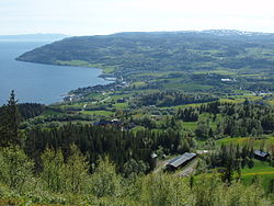

Coat of arms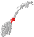
Nord-Trøndelag within
NorwayLeksvik within Nord-Trøndelag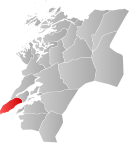
Coordinates: 63°39′59″N 10°29′29″E / 63.66639°N 10.49139°ECoordinates: 63°39′59″N 10°29′29″E / 63.66639°N 10.49139°E Country Norway County Nord-Trøndelag Administrative centre Leksvik Government – Mayor (2007) Einar Strøm (Sp) Area – Total 430.21 km2 (166.1 sq mi) – Land 399.68 km2 (154.3 sq mi) – Water 30.53 km2 (11.8 sq mi) Area rank 230 in Norway Population (2011) – Total 3,522 – Rank 246 in Norway – Density 8.8/km2 (22.8/sq mi) – Change (10 years) 0.1 % Demonym Leksværing[1] Time zone CET (UTC+1) – Summer (DST) CEST (UTC+2) ISO 3166 code NO-1718 Official language form Neutral Website leksvik.kommune.no Data from Statistics Norway Leksvik is a village and a municipality in Nord-Trøndelag county, Norway. The administrative center of the municipality is the village of Leksvik. Other villages in Leksvik include Vanvikan, Seter, and Dalbygda. Norwegian County Road 755 is the main road that connects the whole municipality from north to south.
The 1.65-square-kilometre (410-acre) village of Leksvik has a population (2009) of 1,138. The population density of the village is 690 inhabitants per square kilometre (1,800 /sq mi).[2] Leksvik and Vanvikan are especially known for their high tech industries which have developed to become advanced and in demand. Areas with agriculture are also widespread, but most of the municipality is covered in forests and mountains where the wildlife rules with animals such as moose and reindeer. The moose go all the way down to the heart of Leksvik and Vanvikan, where modern downtown areas with commercial and residential developments are growing.
Contents
General information
Leksvik was established as a municipality on 1 January 1838 (see formannskapsdistrikt). It is one of very few municipalities in Norway with unchanged borders since that date.[3]
Name
The Old Norse form of the name was Lexuvík. The first element is the genitive case of a river name Lexa and the last element is vík which means "inlet". The river name is, maybe, derived from the word lax which means "salmon". The name has also, historically, been spelled Lexvigen or Leksviken.[4]
Coat-of-arms
The coat-of-arms is from modern times; they were granted on 28 September 1990. The arms show the blue Trondheimsfjorden and a silver part representing the land with a clover at the end of it to represent life and growth.[5]
Churches
The Church of Norway has one parish (sokn) within the municipality of Leksvik. It is part of the Fosen deanery and the Diocese of Nidaros.
Churches in Leksvik Parish
(Sokn)Church Name Location
of the ChurchYear Built Leksvik Leksvik Church Leksvik 1670 Stranda Stranda Church Vanvikan 1897 Geography
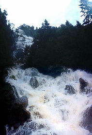 View of the Bjørnåa river and falls
Leksvik is located on the eastern side of the Fosen peninsula along the coast of the Trondheimsfjord. There are two large lakes located in Leksvik: Storvatnet and Meltingvatnet.
History
The first inhabitants are believed to have moved to Leksvik some 3,000 years ago. They left several pieces of cutting tools which are now placed in museums. But Leksvik does not appear in recorded history before the Viking Age when the villages Leksvik and Hindrem became quite important in the local area. In both Leksvik and Hindrem there have been found great tombs and ruins of buildings and longboats. On Borgen, there is a hill between Hindrem and Seter that may have been a great Viking fortress, but this could also be tracks made by the glaciers during the last ice age. After the Black Death struck Norway in 1349, Leksvik fell into silence for some 300 years.
In more modern history, Leksvik and Hindrem are small and relatively isolated villages, north of the Trondheimsfjorden. Two churches stood here, a church in Leksvik and a stave church in Hindrem, but this broke down in 1655 and was replaced by a modern wooden church. In the 19th century, the church of Hindrem was demolished, and the new Stranda Church was built in Vanvikan. Leksvik became well known for its goats and had 5,000 of them at their peak number.
During World War II, Leksvik was settled by German troops with the main camp on the top of Våttåhaugen, a hill north of the village of Leksvik. But as a small and isolated village, nothing of great importance happened there during the war, and it was mostly peaceful although bombs fell over Trondheim, on the south side of the fjord. After electric power first came to Leksvik, Bjørn Lyng founded the first industry in Vanvikan and Leksvik. After the first road was finally finished in the early 1960s, industry grew rapidly and replaced the goats.
Attractions
- Bjørnåa
- Borgen
- Leksvik Church
- Munken
- Stranda Church
- Våttåhaugen
References
- ^ "Personnemningar til stadnamn i Noreg" (in Norwegian). Språkrådet. http://www.sprakrad.no/nb-no/Sprakhjelp/Rettskrivning_Ordboeker/Innbyggjarnamn/.
- ^ Statistisk sentralbyrå (1 January 2009). "Urban settlements. Population and area, by municipality.". http://www.ssb.no/beftett_en/tab-2009-06-16-01-en.html.
- ^ Jukvam, Dag (1999). "Historisk oversikt over endringer i kommune- og fylkesinndelingen" (in Norwegian). Statistisk sentralbyrå. http://www.ssb.no/emner/00/90/rapp_9913/rapp_9913.pdf.
- ^ Rygh, Oluf (1903) (in Norwegian) (dokpro.uio.no). Norske gaardnavne: Nordre Trondhjems amt (15 ed.). Kristiania, Norge: W. C. Fabritius & sønners bogtrikkeri. p. 48. http://www.dokpro.uio.no/perl/navnegransking/rygh_ng/rygh_bla.prl?enhid=239776&avid=53269.
- ^ "Leksvik kommunevåpen" (in Norwegian). Leksvik kommune. http://www.leksvik.kommune.no/sitepageview.aspx?sitePageID=1682. Retrieved 2008-11-02.
External links
- Nord-Trøndelag travel guide from Wikitravel
- Municipal fact sheet from Statistics Norway
- Webcam showing the view from Leksvik in the direction of Frosta
- European ash north to Leksvik
Municipalities of Nord-Trøndelag Current 
Former Categories:- Municipalities of Nord-Trøndelag
- Villages in Nord-Trøndelag
- Leksvik


Wikimedia Foundation. 2010.