- Røyrvik
-
Røyrvik kommune
Raavrevijhke— Municipality — View of the village of Røyrvik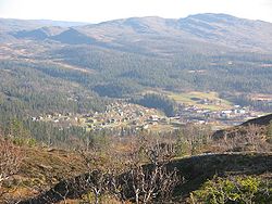

Coat of arms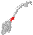
Nord-Trøndelag within
NorwayRøyrvik within Nord-Trøndelag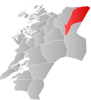
Coordinates: 64°55′15″N 13°39′3″E / 64.92083°N 13.65083°ECoordinates: 64°55′15″N 13°39′3″E / 64.92083°N 13.65083°E Country Norway County Nord-Trøndelag District Namdalen Administrative centre Røyrvik Government – Mayor (2007) Morten Magnar Namsvatn (KrF) Area – Total 1,584.76 km2 (611.9 sq mi) – Land 1,332.40 km2 (514.4 sq mi) – Water 252.36 km2 (97.4 sq mi) Area rank 44 in Norway Population (2011) – Total 499 – Rank 426 in Norway – Density 0.4/km2 (1/sq mi) – Change (10 years) -14.1 % Time zone CET (UTC+1) – Summer (DST) CEST (UTC+2) ISO 3166 code NO-1739 Official language form Neutral Website royrvik.kommune.no Data from Statistics Norway Røyrvik (Southern Sami: Raavrevijhke) is a village and municipality in Nord-Trøndelag county, Norway. It is part of the Namdalen region. The administrative centre of the municipality is the village of Røyrvik. The area has always had a strong Sami influence.
The 0.47-square-kilometre (120-acre) village of Røyrvik sits in the central part of the municipality and serves as the administrative center of the municipality. The village of Røyrvik has a population (2011) of 232, which gives it a population density of 494 inhabitants per square kilometre (1,280 /sq mi).[1]
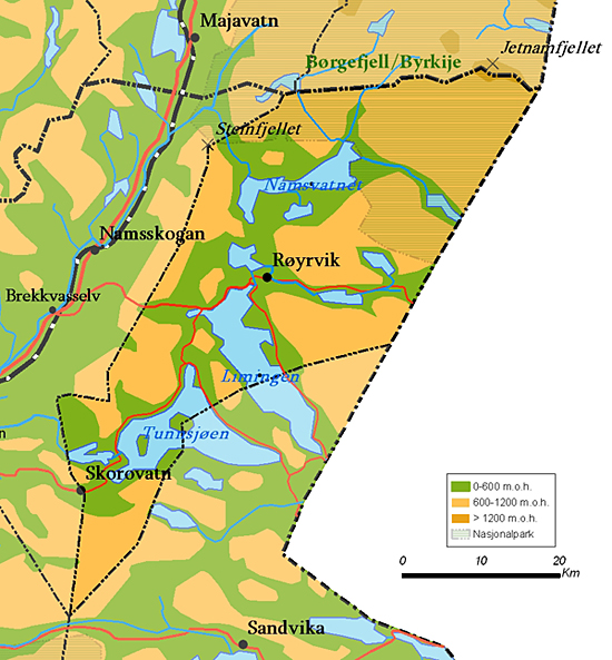
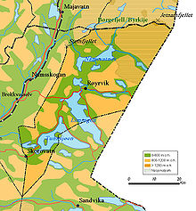 Map of Røyrvik municipality
Contents
General information
The municipality of Røyrvik was established on 1 July 1923 when it was separated from the municipality of Grong. Initially, the population was 392. The municipal boundaries have not since changed.[2]
Name
The municipality (originally the parish) is named after the old Røyrvik farm (historically: Røirviken), since the first church, Røyrvik Church, was built there (in 1828). The first element is røyr which means Arctic char and the last element is vik which means "inlet".[3]
Coat-of-arms
The coat-of-arms is from modern times; they were granted on 13 December 1985. The arms show a silver cross design on a blue background. This design is a common decoration on the pottery, hand-made articles, and traditional pewter embroidery found in the area. These objects were made by the ancestors of the Southern Sámi people presently living in the area. The crosses probably indicate the four points of the compass.[4]
Churches
The Church of Norway has one parish (sokn) within the municipality of Røyrvik. It is part of the Namdal deanery in the Diocese of Nidaros.
Churches in Røyrvik Parish
(Sokn)Church Name Location
of the ChurchYear Built Røyrvik Røyrvik Church Røyrvik 1828 Geography
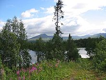 Forest, lakes and mountains in Røyrvik
The area is covered with many large lakes such as Limingen, the 9th largest in Norway. Other lakes include Jengelvatnet, Namsvatnet, Ovrejaevrie, Storgollomsvatnet, Tunnsjøen, and Tunnsjøflyan. The river Namsen begins in the lake Namsvatnet.
The mountainous areas also offer plentiful opportunities for outdoor activities. The highest mountain is the 1,513-metre (4,964 ft) tall Jetnamsklumpen, located inside Børgefjell National Park.
Economy
From 1911 until World War I, mining explorations were conducted in the Gjersvik areas. The modern Grong Gruber mines were active in the Joma area from 1972 until 1998. Farming and reindeer husbandry have always been a source of income in the area. The mining buildings now house various small industrial firms.
A few efforts to create new business include electronics assembly and electronic document management. A small alpine ski resort (Skisenteret) was started in 1986.
References
- ^ Statistisk sentralbyrå (1 January 2011). "Urban settlements. Population and area, by municipality.". http://www.ssb.no/english/subjects/02/01/10/beftett_en/tab-2011-06-17-01-en.html.
- ^ Jukvam, Dag (1999). "Historisk oversikt over endringer i kommune- og fylkesinndelingen" (in Norwegian). Statistisk sentralbyrå. http://www.ssb.no/emner/00/90/rapp_9913/rapp_9913.pdf.
- ^ Rygh, Oluf (1903) (in Norwegian) (dokpro.uio.no). Norske gaardnavne: Nordre Trondhjems amt (15 ed.). Kristiania, Norge: W. C. Fabritius & sønners bogtrikkeri. p. 299. http://www.dokpro.uio.no/perl/navnegransking/rygh_ng/rygh_bla.prl?enhid=249450&avid=55357&s=n.
- ^ Norske Kommunevåpen (1990). "Nye kommunevåbener i Norden". http://www.ngw.nl/int/nor/r/royrvik.htm. Retrieved 13 November 2008.
External links
Municipalities of Nord-Trøndelag Current 
Former Categories:- Villages in Nord-Trøndelag
- Municipalities of Nord-Trøndelag
- Røyrvik


Wikimedia Foundation. 2010.