- Outline of England
-

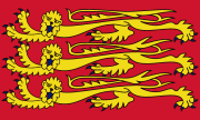 Royal Banner of England
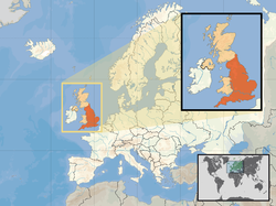

Location of England (orange) – in the European continent (camel & white)
– in the United Kingdom (camel)England is a country that is part of the United Kingdom.[1][2][3] Its 51,092,000 inhabitants account for more than 83% of the total UK population,[4] while its mainland territory occupies most of the southern two-thirds of the island of Great Britain. England is bordered by Scotland to the north, Wales to the west and the North Sea, Irish Sea, Celtic Sea, Bristol Channel and English Channel. The capital is London, the largest metropolitan area in Great Britain, and the largest urban zone in the European Union by many measures.[note 1]
The following outline is provided as an overview of and topical guide to England:
General reference
- Pronunciation: /ˈɪŋɡlənd/ (
 listen)
 - Etymology of "England"
- Common English country name(s): England
- Official English country name(s): England
- Common endonym(s): List of countries and capitals in native languages
- Official endonym(s): List of official endonyms of present-day nations and states
- Adjectival(s): English
- Demonym(s): English
Geography of England
- Main article: Geography of England
- England is: a constituent country of the United Kingdom. See Countries of the United Kingdom.
- Location
- Atlantic Ocean
- Northern Hemisphere, on the Prime Meridian
- Eurasia (but not on the mainland)
- Europe
- Northern Europe and Western Europe
- British Isles
- Great Britain (the southern two-thirds of the island)
- British Isles
- Northern Europe and Western Europe
- Europe
- Extreme points of England
- Demography of England:
- Area of England:
- Places in England
- Atlas of England
Environment of England
- Climate of England
- Geology of England
- National parks of England and Wales
- Fauna of England
Natural geographic features of England
- Estuaries in England
- Islands of England
- Lakes of England
- Mountains and hills of England
- Rivers of England
- Waterfalls of England
Regions of England
Administrative divisions of England
Main article: Administrative divisions of England- Regions of England
- Counties of England
- Districts of England
- Civil parishes in England
- Municipalities of England
- Districts of England
- Unitary authorities of England
- Counties of England
Counties of England
Districts of England
Civil parishes of England
Unitary authorities of England
Main article: Unitary authorities of EnglandMunicipalities of England
Main article: Municipalities of England- Capital of England: Capital of England
- Cities in England
- Towns in England
Demography of England
Government and politics of England
- Main article: Government of England and Politics of England
- Form of government: none.
- England is under the full jurisdiction of the Parliament of the United Kingdom of Great Britain and Northern Ireland and the UK government.
- England is the only country of the UK that doesn't have its own (devolved) government.
- Capital of England: London
- Taxation in England
- West Lothian question
Law and order in England
- Capital punishment in the United Kingdom: none
- Courts of England and Wales
- Human rights in England: same as for the UK
- Freedom of religion in England
- LGBT rights in England: same as for the UK
- Law enforcement in England
- Prison population of England and Wales
- Rights of way in England and Wales
Military of England
- Main article: Military of England
- England does not have its own military. See British Armed Forces.
- Military history of England
Local government of England
History of England
- Battles between Scotland and England
- British Invasion
- Kingdom of England
- Norman conquest of England
- Wars involving England and France
History of England by period
- Prehistoric Britain
- Roman Britain
- Anglo-Saxon England
- Anglo-Norman England
- House of Plantagenet
- House of Lancaster
- House of York
- House of Tudor
- House of Stuart
- The Protectorate
- Commonwealth of England
- Stuart Restoration
- Glorious Revolution
- Kingdom of Great Britain
- United Kingdom of Great Britain and Ireland
- United Kingdom of Great Britain and Northern Ireland
History of England by region
History of England by subject
- History of the Church of England
- History of education in England
- History of the Jews in England
- History of local government in England
- Military history of England
Culture of England
- Architecture of England
- Cuisine of England
- Cultural icons of England
- Ethnic minorities in England
- Gardens in England
- Festivals in England
- British humour
- English inventions and discoveries
- Languages of England
- Marriage in England
- Civil partnership in England
- Media in England
- Museums in England
- National symbols of England
- People of England
- Prostitution in the United Kingdom
- Public holidays in England
- Records of England
- Religion in England
- Buddhism in England
- Christianity in England
- Roman Catholicism in England and Wales
- Hinduism in England
- Islam in England
- Judaism in England
- Sikhism in England
- World Heritage Sites in England
Art of England
Main article: Art in England- Cinema of England
- Comedy in England
- Literature of England
- Music of England
- Television in England
- Theatre in England
Sport in England
Main article: Sports in England- Chess in England
- Cricket in England
- Football in England
- National sports teams of England
- Olympics and England - England does not compete at the Olympic Games, English athletes compete as part of the Great Britain team instead.
- Rugby in England
- Stadiums in England
Economy and infrastructure of England
- Main article: Economy of England
- Agriculture in England
- Banking in England
- Bank of England (central bank of the UK)
- Communications in England
- Internet in England
- Companies of England
- Currency of the United Kingdom: Pound Sterling
- Economic history of England
- Energy in England
- List of power stations in England
- Oil industry in England
- Fire service in the United Kingdom#England
- Health care in England
- History of the National Health Service
- List of hospitals in England
- Mining in England
- Tourism in England
- Transport in England
- List of airports in England
- List of ports in England
- Rail transport in England
- Roads in England
- Water supply and sanitation in England
Education in England
- Main article: Education in England
Types of schools in England
- Grammar schools in the United Kingdom
- Independent school
- Preparatory school
Specific schools in England
Notes
- ^ The official definition of LUZ (Larger Urban Zone) is used by the European Statistical Agency (Eurostat) when describing conurbations and areas of high population. This definition ranks London highest, above Paris (see Larger Urban Zones (LUZ) in the European Union); and a ranking of population within municipal boundaries also puts London on top (see Largest cities of the European Union by population within city limits). However, research by the University of Avignon in France ranks Paris first and London second when including the whole urban area and hinterland, that is the outlying cities as well (see Largest urban areas of the European Union).
See also
- All pages beginning with "England"
- All pages with titles containing "England"
- All pages beginning with "English"
- All pages with titles containing "English"
- List of basic geography topics
- List of international rankings
References
- ^ The Countries of the UK statistics.gov.uk. Retrieved 10 October 2008.
- ^ "Countries within a country". 10 Downing Street. http://www.number-10.gov.uk/output/Page823.asp. Retrieved 2007-09-10. "The United Kingdom is made up of four countries: England, Scotland, Wales and Northern Ireland"
- ^ "ISO 3166-2 Newsletter Date: 2007-11-28 No I-9. "Changes in the list of subdivision names and code elements" (Page 11)" (PDF). International Organisation for Standardisation codes for the representation of names of countries and their subdivisions -- Part 2: Country subdivision codes. http://www.iso.org/iso/newsletter_i-9.pdf. Retrieved 2008-05-31. "ENG England country"
- ^ =15106 "Population estimates for UK, England and Wales, Scotland and Northern Ireland - current datasets". National statistics. Office for National Statistics. http://www.statistics.gov.uk/statbase/Product.asp?vlnk =15106. Retrieved 2009-06-05.
External links
- Official website of the United Kingdom Government
- Office for National Statistics
- English Heritage – national body protecting and promoting English history and heritage.
- English Nature – wildlife and the natural world of England.
- England-related pages from the BBC
- Outline of England travel guide from Wikitravel
- Enjoy England – The official website of the English Tourist Board
- Enjoy England's Travel Blog – Discover England's best hidden gems
- UK & Ireland Genealogy
Outlines General reference · Culture and the arts · Geography and places · Health and fitness · History and events · Mathematics and logic · Natural and physical sciences · People and self · Philosophy and thinking · Religion and belief systems · Society and social sciences · Technology and applied sciencesCategories:- Outlines of countries
- England
- England-related lists
- Pronunciation: /ˈɪŋɡlənd/ (


Wikimedia Foundation. 2010.