- Otterham
-
Coordinates: 50°41′11″N 4°35′43″W / 50.6865°N 4.5953°W
Otterham Cornish: Prasdowrgi 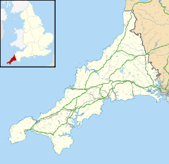
 Otterham
Otterham shown within CornwallPopulation 228 (Civil Parish, 2001) OS grid reference SX 168 907 Parish Otterham Unitary authority Cornwall Ceremonial county Cornwall Region South West Country England Sovereign state United Kingdom Post town CAMELFORD Postcode district PL32 Dialling code 01840 Police Devon and Cornwall Fire Cornwall Ambulance South Western EU Parliament South West England UK Parliament North Cornwall List of places: UK • England • Cornwall Otterham (Cornish: Prasdowrgi) is a village and a civil parish in north Cornwall, United Kingdom. The village is situated approximately ten miles (16 km) south of Bude and six miles (10 km) north of Camelford[1].
Otterham Mill, Otterham Down and Otterham Station (see below) are neighbouring settlements to Otterham village; all take the name from the River Ottery which rises in the parish.
The parish is in the Hundred of Lesnewth and Deanery of Trigg Major. It is in the Registration District of Camelford and belongs to the Boscastle group of Anglican parishes. Otterham parish is bounded to the north by St Gennys, to the east by Warbstow, to the south by Davidstow and to the west by St Juliot. The parish is rural with small hamlets and farmsteads spread fairly evenly across it: the population of the parish in the 2001 census was 228[2].
The parish church of St Denis at grid reference SX 168 907 is in Otterham village and has a 40 ft tower housing three bells. The church was built in the Norman period but was altered in 1889 when the north transept was demolished.
Otterham Station
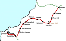 Map of the stations on the North Cornwall Railway
Otterham Station ( 50°40′30″N 4°36′47″W / 50.675°N 4.613°W ) is a settlement one mile south-west of Otterham village at grid reference SX 154 893.
Otterham Station is located at the junction of the A39 trunk road and the B3262 minor road. The settlement grew round the site of the former station on the North Cornwall Railway which closed in October 1966[3].
Hendraburnick Down (1009 ft) is south of Otterham Station and there are a number of Bronze Age barrows (including Tich Barrow) on the Down. The source of the River Camel is also on Hendraburnick Down[1].
For more details about the railway station, see the North Cornwall Railway article.
References
External links
 Media related to Otterham at Wikimedia Commons
Geography of Cornwall Cornwall Portal Unitary authorities Major settlements Bodmin • Bude • Callington • Camborne • Camelford • Falmouth • Fowey • Hayle • Helston • Launceston • Liskeard • Looe • Lostwithiel • Marazion • Newlyn • Newquay • Padstow • Par • Penryn • Penzance • Porthleven • Redruth • Saltash • St Austell • St Blazey • St Columb Major • St Ives • St Just-in-Penwith • St Mawes • Stratton • Torpoint • Truro • Wadebridge
See also: Civil parishes in CornwallRivers Topics History • Status debate • Flag • Culture • Places • People • The Duchy • Diocese • Politics • Hundreds/shires • Places of interest • full list...Civil parishes of North Cornwall constituency  Advent • Altarnun • Blisland • Bodmin • Boyton • Bude–Stratton • Camelford • Cardinham • Davidstow • Egloshayle • Egloskerry • Forrabury and Minster • Helland • Jacobstow • Kilkhampton • Laneast • Lanhydrock • Lanivet • Launceston • Launcells • Lawhitton Rural • Lesnewth • Lewannick • Lezant • Marhamchurch • Michaelstow • Morwenstow • North Hill • North Petherwin • North Tamerton • Otterham • Padstow • Poundstock • South Petherwin • St Breock • St Breward • St Clether • St Endellion • St Ervan • St Eval • St Gennys • St Issey • St Juliot • St Kew • St Mabyn • St Merryn • St Minver Highlands • St Minver Lowlands • St Stephens by Launceston Rural • St Teath • St Thomas the Apostle Rural • St Tudy • Stoke Climsland • Tintagel • Tremaine • Treneglos • Tresmeer • Trevalga • Trewen • Wadebridge • Warbstow • Week St Mary • Werrington • Whitstone • Withiel
Cornwall Portal Categories:- Villages in Cornwall
- Civil parishes in Cornwall
- Bodmin Moor
- Disused railway stations in Cornwall
- Cornwall geography stubs


Wikimedia Foundation. 2010.